FAA INFORMATION EFFECTIVE 19 MARCH 2026
Location
| FAA Identifier: | 2A0 |
| Lat/Long: | 35-29-10.5000N 084-55-51.9000W
35-29.175000N 084-55.865000W
35.4862500,-84.9310833
(estimated) |
| Elevation: | 718.2 ft. / 218.9 m (surveyed) |
| Variation: | 04W (2010) |
| From city: | 4 miles E of DAYTON, TN |
| Time zone: | UTC -4 (UTC -5 during Standard Time) |
| Zip code: | 37321 |
Airport Operations
| Airport use: | Open to the public |
| Activation date: | 08/1962 |
| Control tower: | no |
| ARTCC: | ATLANTA CENTER |
| FSS: | NASHVILLE FLIGHT SERVICE STATION |
| NOTAMs facility: | BNA (NOTAM-D service available) |
| Attendance: | MON-SAT 0900-1700, ALL SUN 1300-1700
CLSD FED HOL. AFT HR TRML DOOR CODE - UNICOM. |
| Wind indicator: | lighted |
| Segmented circle: | yes |
| Lights: | SS-SR |
| Beacon: | white-green (lighted land airport)
Operates sunset to sunrise. |
Airport Communications
| CTAF/UNICOM: | 123.0 |
| WX AWOS-3: | 135.075 (423-775-4695) |
| CHATTANOOGA APPROACH: | 125.1 [0600-2350] |
| CHATTANOOGA DEPARTURE: | 125.1 [0600-2350] |
| WX AWOS-3 at RZR (18 nm S): | 120.475 (423-479-6823) |
| WX AWOS-3 at MMI (19 nm E): | 125.425 (423-745-3422) |
- APCH/DEP SVC PRVDD BY ATLANTA ARTCC ON FREQS 133.6/254.3 (HINCH MOUNTAIN RCAG) WHEN CHATTANOOGA APCH CTL CLSD.
Nearby radio navigation aids
| VOR radial/distance | | VOR name | | Freq | | Var |
|---|
| HCHr175/17.8 | | HINCH MOUNTAIN VOR/DME | | 117.60 | | 02W |
| NDB name | | Hdg/Dist | | Freq | | Var | | ID |
|---|
| DAISY | | 032/22.2 | | 341 | | 02W | | CQN | -.-. --.- -. |
Airport Services
| Fuel available: | 100LL JET-A+
100LL:SELF SVC. |
| Parking: | tiedowns |
| Airframe service: | MAJOR |
| Powerplant service: | MAJOR |
Runway Information
Runway 3/21
| Dimensions: | 5001 x 100 ft. / 1524 x 30 m |
| Surface: | asphalt, in good condition |
| Weight bearing capacity: | | PCN 16 /F/C/X/T | | Single wheel: | 43.5 | | Double wheel: | 62.0 |
|
| Runway edge lights: | medium intensity |
| RUNWAY 3 | | RUNWAY 21 |
| Latitude: | 35-28.812508N | | 35-29.536903N |
| Longitude: | 084-56.106170W | | 084-55.625135W |
| Elevation: | 710.7 ft. | | 718.2 ft. |
| Traffic pattern: | left | | left |
| Runway heading: | 033 magnetic, 029 true | | 213 magnetic, 209 true |
| Markings: | nonprecision, in good condition | | nonprecision, in good condition |
| Visual slope indicator: | 2-light PAPI on left (3.00 degrees glide path) | | 2-light PAPI on left (3.00 degrees glide path) |
| Runway end identifier lights: | yes | | yes |
| Touchdown point: | yes, no lights | | yes, no lights |
| Obstructions: | 21 ft. tree, 810 ft. from runway, 69 ft. right of centerline, 29:1 slope to clear | | 86 ft. tree, 2360 ft. from runway, 572 ft. left of centerline, 25:1 slope to clear |
Airport Ownership and Management from official FAA records
| Ownership: | Publicly-owned |
| Owner: | CITY OF DAYTON
P.O. BOX 226
DAYTON, TN 37321
Phone 423-775-1818 |
| Manager: | BRYAN JANISCH
350 WALTER SQUIRE RD
DAYTON, TN 37321
Phone 423-775-8407 |
Additional Remarks
| - | FOR CD CTC CHATTANOOGA APCH AT 423-855-6478, WHEN APCH CLSD CTC ATLANTA ARTCC AT 770-210-7692. |
| - | WILDLIFE INVOF ARPT. |
Instrument Procedures
NOTE: All procedures below are presented as PDF files. If you need a reader for these files, you should download the free Adobe Reader.NOT FOR NAVIGATION. Please procure official charts for flight.
FAA instrument procedures published for use from 19 March 2026 at 0901Z to 16 April 2026 at 0900Z.
IAPs - Instrument Approach Procedures |
|---|
| RNAV (GPS) RWY 03 | |
download (318KB) |
| RNAV (GPS) RWY 21 | |
download (285KB) |
| NOTE: Special Take-Off Minimums/Departure Procedures apply | |
download (126KB) |
Other nearby airports with instrument procedures:
KRZR - Cleveland Regional Jetport (18 nm S)
KMMI - McMinn County Airport (19 nm E)
KMNV - Monroe County Airport (27 nm E)
KRKW - Rockwood Municipal Airport (29 nm NE)
KCSV - Crossville Memorial Airport-Whitson Field (29 nm N)
|
|

Road maps at:
MapQuest
Bing
Google
| Aerial photo |
|---|
WARNING: Photo may not be current or correct
 Photo taken 17-Feb-2012
looking southwest.
Photo taken 17-Feb-2012
looking southwest.
Do you have a better or more recent aerial photo of Mark Anton Airport that you would like to share? If so, please send us your photo.
|
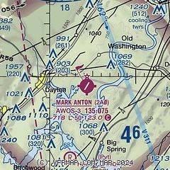
| Sectional chart |
|---|
|
| Airport distance calculator |
|---|
|
|
| Sunrise and sunset |
|---|
|
Times for 11-Apr-2026
| | Local
(UTC-4) | | Zulu
(UTC) |
|---|
| Morning civil twilight | | 06:47 | | 10:47 |
| Sunrise | | 07:14 | | 11:14 |
| Sunset | | 20:08 | | 00:08 |
| Evening civil twilight | | 20:34 | | 00:34 |
|
| Current date and time |
|---|
| Zulu (UTC) | 11-Apr-2026 11:36:02 |
|---|
| Local (UTC-4) | 11-Apr-2026 07:36:02 |
|---|
|
| METAR |
|---|
| K2A0 | 111115Z AUTO 00000KT 10SM CLR 07/07 A3030 RMK A01
|
KRZR
18nm S | 111115Z AUTO 00000KT 6SM BR CLR 06/06 A3030 RMK A01
|
KMMI
19nm E | 111115Z AUTO 00000KT 10SM CLR 06/06 A3034 RMK A01
|
|
| TAF |
|---|
KCSV
29nm N | 110526Z 1106/1206 00000KT P6SM SKC FM111600 32005KT P6SM FEW060
|
KCHA
30nm SW | 110543Z 1106/1206 VRB04KT P6SM SCT250
|
|
| NOTAMs |
|---|
NOTAMs are issued by the DoD/FAA and will open in a separate window not controlled by AirNav.
|
|

