FAA INFORMATION EFFECTIVE 09 JULY 2026
Location
| FAA Identifier: | 3GM |
| Lat/Long: | 43-02-02.6000N 086-11-53.4000W
43-02.043333N 086-11.890000W
43.0340556,-86.1981667
(estimated) |
| Elevation: | 603.8 ft. / 184.0 m (surveyed) |
| Variation: | 05W (2005) |
| From city: | 2 miles SE of GRAND HAVEN, MI |
| Time zone: | UTC -4 (UTC -5 during Standard Time) |
| Zip code: | 49417 |
Airport Operations
| Airport use: | Open to the public |
| Activation date: | 08/1949 |
| Control tower: | no |
| ARTCC: | CHICAGO CENTER |
| FSS: | LANSING FLIGHT SERVICE STATION |
| NOTAMs facility: | LAN (NOTAM-D service available) |
| Attendance: | 0900-1700
UNATNDD MAJOR HOLS. FOR SVC & FLD CONDS AFT HRS CALL AMGR CELL. |
| Wind indicator: | lighted |
| Segmented circle: | yes |
| Lights: | ACTVT REIL RWY 09 & 27; PAPI RWY 09 & 27; MIRL RWY 09/27 & 18/36 - CTAF. |
| Beacon: | white-green (lighted land airport)
Operates sunset to sunrise. |
Airport Communications
| CTAF/UNICOM: | 122.7 |
| GREAT LAKES APPROACH: | 133.825 |
| GREAT LAKES DEPARTURE: | 133.825 |
| WX ASOS at MKG (8 nm N): | PHONE 231-246-4419 |
| WX ASOS at BIV (18 nm S): | 119.025 (616-394-0190) |
- APCH/DEP SVC PRVDD BY CHICAGO ARTCC ON FREQS 128.5/273.525 (PULLMAN RCAG) WHEN GREAT LAKES APCH CTL CLSD.
Nearby radio navigation aids
| VOR radial/distance | | VOR name | | Freq | | Var |
|---|
| VIOr300/34.2 | | VICTORY VOR/DME | | 115.95 | | 04W |
Airport Services
| Fuel available: | 100LL JET-A |
| Parking: | hangars and tiedowns |
| Airframe service: | MAJOR |
| Powerplant service: | MAJOR |
Runway Information
Runway 9/27
| Dimensions: | 3752 x 75 ft. / 1144 x 23 m |
| Surface: | asphalt, in excellent condition |
| Weight bearing capacity: | |
| Runway edge lights: | medium intensity |
| RUNWAY 9 | | RUNWAY 27 |
| Latitude: | 43-02.049070N | | 43-02.049227N |
| Longitude: | 086-12.201458W | | 086-11.359485W |
| Elevation: | 602.3 ft. | | 591.5 ft. |
| Traffic pattern: | left | | left |
| Runway heading: | 095 magnetic, 090 true | | 275 magnetic, 270 true |
| Markings: | nonprecision, in good condition | | nonprecision, in good condition |
| Visual slope indicator: | 2-light PAPI on left (3.00 degrees glide path) | | 2-light PAPI on left (4.00 degrees glide path) |
| Runway end identifier lights: | yes | | yes |
| Touchdown point: | yes, no lights | | yes, no lights |
| Obstructions: | 45 ft. trees, 941 ft. from runway, 300 ft. right of centerline, 16:1 slope to clear | | 45 ft. tree, 675 ft. from runway, 321 ft. left of centerline, 10:1 slope to clear |
Runway 18/36
| Dimensions: | 2058 x 60 ft. / 627 x 18 m |
| Surface: | asphalt, in fair condition |
| Weight bearing capacity: | |
| Runway edge lights: | medium intensity |
| RUNWAY 18 | | RUNWAY 36 |
| Latitude: | 43-02.200652N | | 43-01.861767N |
| Longitude: | 086-12.087575W | | 086-12.087965W |
| Elevation: | 603.8 ft. | | 598.4 ft. |
| Traffic pattern: | left | | left |
| Runway heading: | 185 magnetic, 180 true | | 005 magnetic, 000 true |
| Markings: | basic, in fair condition | | basic, in fair condition |
| Touchdown point: | yes, no lights | | yes, no lights |
| Obstructions: | 15 ft. road, 330 ft. from runway, 138 ft. left and right of centerline, 8:1 slope to clear | | 11 ft. road, 285 ft. from runway, 134 ft. left and right of centerline, 7:1 slope to clear |
Airport Ownership and Management from official FAA records
| Ownership: | Publicly-owned |
| Owner: | CITY OF GRAND HAVEN
519 WASHINGTON AVE
GRAND HAVEN, MI 49417-1454
Phone 616-842-3210 |
| Manager: | EARLE BARES
16446 COMSTOCK ST
GRAND HAVEN, MI 49417-9423
Phone 616-842-4430
CELL 616-847-0638. |
Additional Remarks
| - | UAS OPS WEST OF RWY 18 & NORTH OF RWY 09. |
| - | DEER & LRG BIRDS ON & INVOF ARPT. |
| - | PAJA SFC-14000 FT DLY SR-SS APR-OCT. |
| - | FOR CD CTC GREAT LAKES APCH AT 269-459-3344, WHEN APCH CLSD CTC CHICAGO ARTCC AT 630-906-8921. |
| - | LRG VEHICLE TFC ON ROADS IN RWY 18 & 36 APCH AREAS. |
Instrument Procedures
NOTE: All procedures below are presented as PDF files. If you need a reader for these files, you should download the free Adobe Reader.NOT FOR NAVIGATION. Please procure official charts for flight.
FAA instrument procedures published for use from 09 July 2026 at 0901Z to 06 August 2026 at 0900Z.
IAPs - Instrument Approach Procedures |
|---|
| RNAV (GPS) RWY 09 | |
download (178KB) |
| RNAV (GPS) RWY 27 | |
download (186KB) |
| NOTE: Special Take-Off Minimums/Departure Procedures apply | |
download (347KB) |
Other nearby airports with instrument procedures:
KMKG - Muskegon County Airport (8 nm N)
Z98 - Ottawa Executive Airport (18 nm SE)
KBIV - West Michigan Regional Airport (18 nm S)
8D4 - Paul C Miller/Sparta Airport (23 nm E)
KFFX - Fremont Municipal Airport (26 nm N)
|
|

Road maps at:
MapQuest
Bing
Google
| Aerial photo |
|---|
WARNING: Photo may not be current or correct
 Photo by Brad Fisher
Photo taken 01-Oct-2009
looking WNW towards Lake Michigan.
Photo by Brad Fisher
Photo taken 01-Oct-2009
looking WNW towards Lake Michigan.
Do you have a better or more recent aerial photo of Grand Haven Memorial Airpark that you would like to share? If so, please send us your photo.
|
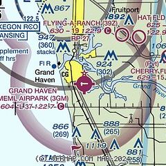
| Sectional chart |
|---|
|
| Airport distance calculator |
|---|
|
|
| Sunrise and sunset |
|---|
|
Times for 30-Jul-2026
| | Local
(UTC-4) | | Zulu
(UTC) |
|---|
| Morning civil twilight | | 06:02 | | 10:02 |
| Sunrise | | 06:34 | | 10:34 |
| Sunset | | 21:08 | | 01:08 |
| Evening civil twilight | | 21:40 | | 01:40 |
|
| Current date and time |
|---|
| Zulu (UTC) | 30-Jul-2026 13:05:13 |
|---|
| Local (UTC-4) | 30-Jul-2026 09:05:13 |
|---|
|
| METAR |
|---|
KMKG
8nm N | 301255Z 00000KT 10SM FEW250 23/14 A3006 RMK AO2 SLP178 T02280144 $
|
KBIV
18nm S | 301253Z AUTO 33003KT 10SM CLR 22/14 A3008 RMK AO2 SLP182 T02220144
|
|
| TAF |
|---|
KMKG
8nm N | 301140Z 3012/3112 VRB03KT P6SM SKC FM301600 26008KT P6SM SKC FM310000 VRB03KT P6SM SKC
|
|
| NOTAMs |
|---|
NOTAMs are issued by the DoD/FAA and will open in a separate window not controlled by AirNav.
|
|

