FAA INFORMATION EFFECTIVE 27 NOVEMBER 2025
Location
| FAA Identifier: | 3GV |
| Lat/Long: | 39-00-52.7083N 094-12-53.4904W
39-00.878472N 094-12.891507W
39.0146412,-94.2148584
(estimated) |
| Elevation: | 835 ft. / 255 m (estimated) |
| Variation: | 03E (2000) |
| Time zone: | UTC -6 (UTC -5 during Daylight Saving Time) |
| Zip code: | 64029 |
Airport Operations
| Airport use: | Open to the public |
| Activation date: | 09/1956 |
| Control tower: | no |
| ARTCC: | KANSAS CITY CENTER |
| FSS: | COLUMBIA FLIGHT SERVICE STATION |
| NOTAMs facility: | COU (NOTAM-D service available) |
| Attendance: | 0800-DUSK |
| Wind indicator: | lighted, WIND SOCK |
| Segmented circle: | no |
| Lights: | ACTVT REIL RWY 09; MIRL RWY 09/27 - CTAF. |
| Beacon: | white-green (lighted land airport)
Operates sunset to sunrise. |
Airport Communications
| CTAF/UNICOM: | 122.8 |
| KANSAS CITY APPROACH: | 118.4 |
| KANSAS CITY DEPARTURE: | 118.4 |
| CLEARANCE DELIVERY: | 121.3 |
| WX ASOS at LXT (8 nm SW): | 124.175 (816-347-9807) |
| WX ASOS at MKC (19 nm W): | 120.75 (816-329-2843) |
| WX AWOS-3P at GPH (20 nm N): | 120.275 (816-407-3399) |
Nearby radio navigation aids
| VOR radial/distance | | VOR name | | Freq | | Var |
|---|
| ANXr213/6.3 | | NAPOLEON VORTAC | | 115.15 | | 07E |
| MCIr119/29.2 | | KANSAS CITY VORTAC | | 113.25 | | 05E |
Airport Services
| Fuel available: | 100LL |
| Parking: | hangars and tiedowns |
| Airframe service: | MAJOR |
| Powerplant service: | MAJOR |
| Bottled oxygen: | NONE |
| Bulk oxygen: | NONE |
Runway Information
Runway 9/27
| Dimensions: | 4507 x 44 ft. / 1374 x 13 m
WIDTH VARIANCE 44-45 FT. |
| Surface: | asphalt, in excellent condition |
| Weight bearing capacity: | |
| Runway edge lights: | medium intensity
NSTD MIRL; NO YELLOW EDGE LGTS LAST 2000 FT BOTH ENDS; ALL EDGE LGTS LCTD 13-15 FT FM PAVEMENT EDGE; RWY 27 ONLY 6 THR LGTS LCTD 18-20 FT E OF THR. |
| RUNWAY 9 | | RUNWAY 27 |
| Latitude: | 39-00.855333N | | 39-00.838833N |
| Longitude: | 094-13.416500W | | 094-12.465167W |
| Elevation: | 817.0 ft. | | 817.9 ft. |
| Traffic pattern: | right | | left |
| Runway heading: | 088 magnetic, 091 true | | 268 magnetic, 271 true |
| Displaced threshold: | 303 ft. | | no |
| Markings: | nonprecision, in good condition | | nonprecision, in good condition |
| Runway end identifier lights: | yes | | |
| Touchdown point: | yes, no lights | | yes, no lights |
| Obstructions: | 23 ft. rr, 201 ft. from runway, 200 ft. right of centerline, 1:1 slope to clear
RWY 09 1-20 FT GND 0-200 FT FM RWY END LEFT & RIGHT; +16 FT SIGNS 145 FT FM RWY END 80 FT LEFT; 10-25 FT ROAD 0-200 FT FM RWY END 125-160 FT LEFT; +1-50 FT TREES & RR 0-200 FT FM RWY END 200-250 FT RIGHT. | | 15 ft. rr, 201 ft. from runway, 175 ft. left of centerline, 1:1 slope to clear
+1-33 FT BRUSH; TREES; FENCE; RR; ROAD & BLDGS 0-200 FT FM RWY END LEFT & RIGHT. |
Runway 5/23
| Dimensions: | 2206 x 20 ft. / 672 x 6 m
WIDTH VARIANCE 20-25 FT. |
| Surface: | asphalt, in excellent condition |
| Weight bearing capacity: | |
| RUNWAY 5 | | RUNWAY 23 |
| Latitude: | 39-00.844333N | | 39-01.040833N |
| Longitude: | 094-12.986667W | | 094-12.594833W |
| Elevation: | 818.1 ft. | | 833.4 ft. |
| Traffic pattern: | left | | right |
| Runway heading: | 054 magnetic, 057 true | | 234 magnetic, 237 true |
| Markings: | basic, in good condition | | basic, in good condition |
| Touchdown point: | yes, no lights | | yes, no lights |
| Obstructions: | 32 ft. trees, 230 ft. from runway, 90 ft. right of centerline, 1:1 slope to clear
RR TRACK 0-200 FT FROM RWY, 80-230 FT RIGHT; TREES 20-35 FT, 0-200 FT FROM RWY, 130-250 FT RIGHT. | | 56 ft. trees, 656 ft. from runway, 207 ft. right of centerline, 8:1 slope to clear
HNGR BLDG 16-26 FT, 125-200 FT FM RWY END, 180-250 FT LEFT. |
Airport Ownership and Management from official FAA records
| Ownership: | Privately-owned |
| Owner: | GRAIN VALLEY AIRPORT CORP
BOX 255
GRAIN VALLEY, MO 64029
Phone 816-229-8868 |
| Manager: | DAN WILLIAMS
BOX 255, 600 EE KIRBY RD
GRAIN VALLEY, MO 64029
Phone 816-286-9206 |
Additional Remarks
| - | WATERFOWL ON & INVOF ARPT. |
| - | NTSD RWY SAFETY AREA ALL RWY ENDS; INSUFFICIENT LENS & INCOR TRRN GRADES; NO RWY SAFETY AREA BYD RWY 05 & 27. |
| - | FOR CD CTC KANSAS CITY APCH AT 816-329-2710. |
Instrument Procedures
NOTE: All procedures below are presented as PDF files. If you need a reader for these files, you should download the free Adobe Reader.NOT FOR NAVIGATION. Please procure official charts for flight.
FAA instrument procedures published for use from 27 November 2025 at 0901Z to 25 December 2025 at 0900Z.
IAPs - Instrument Approach Procedures |
|---|
| RNAV (GPS) RWY 09 | |
download (201KB) |
| RNAV (GPS) RWY 27 | |
download (185KB) |
| NOTE: Special Take-Off Minimums/Departure Procedures apply | |
download |
Other nearby airports with instrument procedures:
KLXT - Kansas City/Lee's Summit Regional Airport (8 nm SW)
KMKC - Kansas City Downtown Airport-Wheeler Field (19 nm W)
3EX - Excelsior Springs Memorial Airport (19 nm N)
KGPH - Midwest National Air Center Airport (20 nm N)
KRCM - Skyhaven Airport (24 nm SE)
|
|

Road maps at:
MapQuest
Bing
Google
| Aerial photo |
|---|
WARNING: Photo may not be current or correct
 Photo by Richard Bullock
Photo taken 21-Jul-2012
looking south.
Photo by Richard Bullock
Photo taken 21-Jul-2012
looking south.
Do you have a better or more recent aerial photo of East Kansas City Airport that you would like to share? If so, please send us your photo.
|
| Sectional chart |
|---|
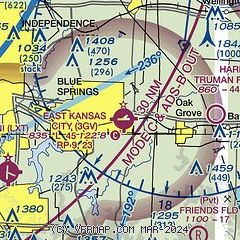
|
CAUTION: Diagram may not be current

| Airport distance calculator |
|---|
|
|
| Sunrise and sunset |
|---|
|
Times for 10-Dec-2025
| | Local
(UTC-6) | | Zulu
(UTC) |
|---|
| Morning civil twilight | | 06:56 | | 12:56 |
| Sunrise | | 07:26 | | 13:26 |
| Sunset | | 16:53 | | 22:53 |
| Evening civil twilight | | 17:23 | | 23:23 |
|
| Current date and time |
|---|
| Zulu (UTC) | 11-Dec-2025 03:24:39 |
|---|
| Local (UTC-6) | 10-Dec-2025 21:24:39 |
|---|
|
| METAR |
|---|
KLXT
8nm W | 110253Z AUTO 34006KT 10SM FEW120 01/M04 A3009 RMK AO2 SLP198 I1001 I3001 T00111039 53013 $
|
KMKC
19nm W | 110254Z 34006KT 10SM SCT120 02/M03 A3010 RMK AO2 SLP197 T00221033 51014
|
KGPH
20nm N | 110255Z AUTO 00000KT 10SM BKN120 01/M03 A3010 RMK AO2
|
KGVW
20nm SW | 110255Z AUTO 05013KT 10SM FEW040 19/13 A3007 RMK A01
|
|
| TAF |
|---|
KMKC
19nm W | 101721Z 1018/1118 31014G22KT P6SM SCT035 FM102000 33013G21KT P6SM SCT035 FM102300 32009KT P6SM SCT240 FM111300 15005KT P6SM BKN090
|
|
| NOTAMs |
|---|
NOTAMs are issued by the DoD/FAA and will open in a separate window not controlled by AirNav.
|
|


