FAA INFORMATION EFFECTIVE 27 NOVEMBER 2025
Location
| FAA Identifier: | RCM |
| Lat/Long: | 38-47-03.0160N 093-48-10.2750W
38-47.050267N 093-48.171250W
38.7841711,-93.8028542
(estimated) |
| Elevation: | 797.9 ft. / 243.2 m (surveyed) |
| Variation: | 01E (2015) |
| From city: | 3 miles NW of WARRENSBURG, MO |
| Time zone: | UTC -6 (UTC -5 during Daylight Saving Time) |
| Zip code: | 64093 |
Airport Operations
| Airport use: | Open to the public |
| Activation date: | 12/1946 |
| Control tower: | no |
| ARTCC: | KANSAS CITY CENTER |
| FSS: | COLUMBIA FLIGHT SERVICE STATION |
| NOTAMs facility: | COU (NOTAM-D service available) |
| Attendance: | OCT - MAR MON-FRI 0700-1800, APR- SEPT MON-FRI 0700- 1900, ALL SAT 0800-1700, ALL SUN 0800-1600 |
| Wind indicator: | lighted |
| Segmented circle: | yes |
| Lights: | ACTVT REIL RWY 14 & 32; PAPI RWY 01 & 19; MIRL RWY 01/19 & 14/32 - CTAF. |
| Beacon: | white-green (lighted land airport)
Operates sunset to sunrise. |
Airport Communications
| CTAF/UNICOM: | 123.0 |
| WX AWOS-3PT: | 119.575 (660-422-7010) |
| WHITEMAN APPROACH: | 127.45 |
| WHITEMAN DEPARTURE: | 125.925 |
- APCH/DEP SVC PRVDD BY KANSAS CITY ARTCC ON FREQS 135.575/323.15 (KNOB NOSTER RCAG) WHEN WHITEMAN APCH CTL CLSD.
Nearby radio navigation aids
| VOR radial/distance | | VOR name | | Freq | | Var |
|---|
| ANXr134/24.1 | | NAPOLEON VORTAC | | 115.15 | | 07E |
Airport Services
| Fuel available: | 100LL |
| Parking: | hangars and tiedowns |
| Airframe service: | NONE |
| Powerplant service: | NONE |
| Bottled oxygen: | NONE |
| Bulk oxygen: | NONE |
Runway Information
Runway 1/19
| Dimensions: | 4206 x 75 ft. / 1282 x 23 m |
| Surface: | concrete, in good condition |
| Weight bearing capacity: | | Single wheel: | 21.0 | | Double wheel: | 26.0 |
|
| Runway edge lights: | medium intensity |
| RUNWAY 1 | | RUNWAY 19 |
| Latitude: | 38-46.825428N | | 38-47.511305N |
| Longitude: | 093-48.209997W | | 093-48.085132W |
| Elevation: | 788.3 ft. | | 795.3 ft. |
| Traffic pattern: | left | | right |
| Runway heading: | 007 magnetic, 008 true | | 187 magnetic, 188 true |
| Markings: | nonprecision, in good condition | | nonprecision, in good condition |
| Visual slope indicator: | 4-light PAPI on left (3.00 degrees glide path) | | 4-light PAPI on left (3.00 degrees glide path) |
| Runway end identifier lights: | yes | | yes |
| Touchdown point: | yes, no lights | | yes, no lights |
| Obstructions: | 39 ft. trees, 700 ft. from runway, 165 ft. left of centerline, 12:1 slope to clear | | none |
Runway 14/32
| Dimensions: | 2801 x 60 ft. / 854 x 18 m |
| Surface: | asphalt, in good condition |
| Weight bearing capacity: | |
| Runway edge lights: | medium intensity |
| RUNWAY 14 | | RUNWAY 32 |
| Latitude: | 38-47.042202N | | 38-46.703695N |
| Longitude: | 093-48.407088W | | 093-48.006527W |
| Elevation: | 797.9 ft. | | 785.6 ft. |
| Traffic pattern: | right | | left |
| Runway heading: | 136 magnetic, 137 true | | 316 magnetic, 317 true |
| Markings: | basic, in fair condition | | basic, in fair condition |
| Runway end identifier lights: | yes | | yes |
| Touchdown point: | yes, no lights | | yes, no lights |
| Obstructions: | 20 ft. trees, 480 ft. from runway, 98 ft. right of centerline, 14:1 slope to clear | | 15 ft. road, 375 ft. from runway, 125 ft. left and right of centerline, 11:1 slope to clear |
Airport Ownership and Management from official FAA records
| Ownership: | Publicly-owned |
| Owner: | UNIV. OF CENTRAL MISSOURI
T.R. GAINES, BLDG 210
WARRENSBURG, MO 64093
Phone 660-543-4916 |
| Manager: | CHRIS HOLLAND
UNIVERSITY OF CENTRAL MISSOURI, 281 NW US 50 HWY
WARRENSBURG, MO 64093
Phone 660-543-4916
660-422-1110 |
Additional Remarks
| A30A-01 | CALM WIND RWY. |
| - | SOUTH 100 FT OF APRON & EXIT RAMP LCTD 1250 FT N OF RWY 01 THR HAS SAME PAVEMENT STRENGTH AS RWY 01/19; REMAINDER OF APRON NOT FULL STRENGTH. |
| - | LIMITED SIGHT DSTC FM RWY 14 THR AREA TO RWY 19 THR AND FM RWY 19 THR TO RWY 32 THR AREA. |
| - | HIGH VOL STUDENT TRNG INVOF ARPT FM 0700-1730 LCL MON THRU FRI. |
| - | FOR CD CTC WHITEMAN APCH AT 660-687-3132. WHEN WHITEMAN APCH IS CLSD, CTC KANSAS CITY ARTCC AT 913-254-8508. |
Instrument Procedures
NOTE: All procedures below are presented as PDF files. If you need a reader for these files, you should download the free Adobe Reader.NOT FOR NAVIGATION. Please procure official charts for flight.
FAA instrument procedures published for use from 27 November 2025 at 0901Z to 25 December 2025 at 0900Z.
IAPs - Instrument Approach Procedures |
|---|
| RNAV (GPS) RWY 01 | |
download (240KB) |
| RNAV (GPS) RWY 19 | |
download (240KB) |
| NOTE: Special Alternate Minimums apply | |
download (145KB) |
| NOTE: Special Take-Off Minimums/Departure Procedures apply | |
download (432KB) |
Other nearby airports with instrument procedures:
KSZL - Whiteman Air Force Base (12 nm E)
KHIG - Higginsville Industrial Municipal Airport (18 nm N)
3GV - East Kansas City Airport (24 nm NW)
KGLY - Clinton Regional Airport (26 nm S)
KLRY - Lawrence Smith Memorial Airport (27 nm W)
|
|

Road maps at:
MapQuest
Bing
Google
| Aerial photo |
|---|
WARNING: Photo may not be current or correct
 Photo by Eve Cascella
Photo taken 19-Apr-2010
Photo by Eve Cascella
Photo taken 19-Apr-2010
Do you have a better or more recent aerial photo of Skyhaven Airport that you would like to share? If so, please send us your photo.
|
| Sectional chart |
|---|
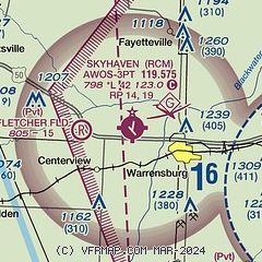
|
| Airport distance calculator |
|---|
|
|
| Sunrise and sunset |
|---|
|
Times for 09-Dec-2025
| | Local
(UTC-6) | | Zulu
(UTC) |
|---|
| Morning civil twilight | | 06:53 | | 12:53 |
| Sunrise | | 07:23 | | 13:23 |
| Sunset | | 16:52 | | 22:52 |
| Evening civil twilight | | 17:22 | | 23:22 |
|
| Current date and time |
|---|
| Zulu (UTC) | 09-Dec-2025 12:35:31 |
|---|
| Local (UTC-6) | 09-Dec-2025 06:35:31 |
|---|
|
| METAR |
|---|
| KRCM | 091215Z AUTO 20007KT 10SM CLR 02/00 A2995 RMK AO2
|
KSZL
13nm E | 091155Z 22008KT 10SM FEW100 03/M01 A2996 RMK AO2A SLP155 T00271008 10033 20017 57015 VISNO RWY01 CHINO RWY01 $
|
|
| TAF |
|---|
KSZL
13nm E | 091100Z 0911/1017 22009KT 9999 SCT100 QNH2992INS BECMG 0914/0915 21012G18KT 9999 FEW030 SCT100 QNH2967INS BECMG 0923/0924 22009KT 9999 BKN120 WS020/24040KT 621207 QNH2966INS BECMG 1010/1011 30012KT 9999 SCT040 WS020/31040KT QNH2976INS BECMG 1014/1015 33025G35KT 9999 BKN040 650406 510005 QNH2989INS TX11/0921Z TN01/0911Z
|
|
| NOTAMs |
|---|
NOTAMs are issued by the DoD/FAA and will open in a separate window not controlled by AirNav.
|
|


