FAA INFORMATION EFFECTIVE 19 MARCH 2026
Location
| FAA Identifier: | 3NP |
| Lat/Long: | 42-10-15.6137N 084-15-33.5114W
42-10.260228N 084-15.558523W
42.1710038,-84.2593087
(estimated) |
| Elevation: | 963 ft. / 293.5 m (surveyed) |
| Variation: | 05W (1985) |
| From city: | 1 mile NW of NAPOLEON, MI |
| Time zone: | UTC -4 (UTC -5 during Standard Time) |
| Zip code: | 49201 |
Airport Operations
| Airport use: | Open to the public |
| Activation date: | 07/1948 |
| Control tower: | no |
| ARTCC: | CLEVELAND CENTER |
| FSS: | LANSING FLIGHT SERVICE STATION |
| NOTAMs facility: | LAN (NOTAM-D service available) |
| Attendance: | UNATNDD |
| Wind indicator: | yes |
| Segmented circle: | yes |
Airport Communications
| CTAF: | 122.9 |
| WX ASOS at JXN (10 nm NW): | PHONE 517-768-7506 |
| WX ASOS at ADG (20 nm SE): | 118.825 (517-265-9089) |
Nearby radio navigation aids
| VOR radial/distance | | VOR name | | Freq | | Var |
|---|
| SVMr247/32.8 | | SALEM VORTAC | | 114.30 | | 03W |
| CRLr285/36.4 | | CARLETON VOR/DME | | 115.70 | | 03W |
| DXOr272/39.8 | | DETROIT VOR/DME | | 113.40 | | 06W |
| NDB name | | Hdg/Dist | | Freq | | Var | | ID |
|---|
| ADRIAN | | 342/19.8 | | 278 | | 06W | | ADG | .- -.. --. |
Airport Services
| Parking: | tiedowns |
| Airframe service: | NONE |
| Powerplant service: | NONE |
| Bottled oxygen: | NONE |
| Bulk oxygen: | NONE |
Runway Information
Runway 9/27
| Dimensions: | 2740 x 200 ft. / 835 x 61 m |
| Surface: | turf, in good condition
SOFT IN SPRING. |
| Runway edge markings: | 3 FT YELLOW CONES. |
| Operational restrictions: | NOT PLOWED IN WINTER. |
| RUNWAY 9 | | RUNWAY 27 |
| Latitude: | 42-10.263333N | | 42-10.266667N |
| Longitude: | 084-15.783333W | | 084-15.176667W |
| Elevation: | 963.0 ft. | | 963.0 ft. |
| Traffic pattern: | left | | left |
| Runway heading: | 095 magnetic, 090 true | | 275 magnetic, 270 true |
| Obstructions: | 62 ft. tree, 131 ft. from runway, 1:1 slope to clear
APCH RATIO 17:1 TO DTHR OVR 111 FT TREE, 1971 FT DIST, 113 FT R. | | 24 ft. tree, 15 ft. from runway, 116 ft. left of centerline, 1:1 slope to clear |
Runway 15/33
| Dimensions: | 2500 x 160 ft. / 762 x 49 m |
| Surface: | turf, in fair condition
SOFT IN SPRING. |
| Runway edge markings: | 3 FT YELLOW CONES; DTHR MKD WITH 3 CONES EACH SIDE. |
| Operational restrictions: | NOT PLOWED IN WINTER. |
| RUNWAY 15 | | RUNWAY 33 |
| Latitude: | 42-10.438333N | | 42-10.071667N |
| Longitude: | 084-15.770000W | | 084-15.519167W |
| Elevation: | 963.0 ft. | | 963.0 ft. |
| Traffic pattern: | left | | left |
| Runway heading: | 158 magnetic, 153 true | | 338 magnetic, 333 true |
| Displaced threshold: | 290 ft. | | 550 ft. |
| Obstructions: | 15 ft. road, 108 ft. right of centerline, 1:1 slope to clear
APCH RATIO 4:1 TO DTHR OVR 41 FT TREE, 183 FT DIST, 134 FT R. | | 13 ft. bldg, 96 ft. from runway, 134 ft. left of centerline, 1:1 slope to clear
APCH RATIO 19:1 TO DTHR OVR 83 FT TREE, 1586 FT DIST, 207 FT L. |
Airport Ownership and Management from official FAA records
| Ownership: | Privately-owned |
| Owner: | BSC REALTY, LLC
211 N UNION ST
TECUMSEH, MI 49286-1342
Phone 517-499-8421 |
| Manager: | SAMUEL OWEN KELLY
211 N UNION ST
TECUMSEH, MI 49286-1342
Phone 734-353-7900 |
Additional Remarks
| - | OIL TANKS SOUTH OF ARPT. |
| - | ULTRALIGHT OPS IN GRASS WEST OF RWY 15/33. |
| - | DEER & LRG BIRDS ON & INVOF ARPT. |
| - | FOR CD CTC GREAT LAKES APCH AT 269-459-3345, WHEN APCH CLSD CTC CLEVELAND ARTCC AT 440-774-0224/0490. |
| - | RWY 09 DTHR 1537 FT, EXTDS BYD RWY MIDPT. |
Instrument Procedures
There are no published instrument procedures at 3NP.
Some nearby airports with instrument procedures:
KJXN - Jackson County Airport/Reynolds Field (10 nm NW)
KADG - Lenawee County Airport (20 nm SE)
KJYM - Hillsdale Municipal Airport (21 nm SW)
KARB - Ann Arbor Municipal Airport (23 nm E)
KTEW - Mason Jewett Field Airport (25 nm N)
|
|

Road maps at:
MapQuest
Bing
Google
| Aerial photo |
|---|
WARNING: Photo may not be current or correct
 Photo by Roy Carlson, Plainwell MI
Taken in August 2005
Photo by Roy Carlson, Plainwell MI
Taken in August 2005
Do you have a better or more recent aerial photo of Napoleon Airport that you would like to share? If so, please send us your photo.
|
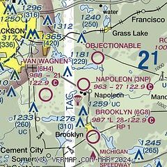
| Sectional chart |
|---|
|
| Airport distance calculator |
|---|
|
|
| Sunrise and sunset |
|---|
|
Times for 03-Apr-2026
| | Local
(UTC-4) | | Zulu
(UTC) |
|---|
| Morning civil twilight | | 06:49 | | 10:49 |
| Sunrise | | 07:17 | | 11:17 |
| Sunset | | 20:04 | | 00:04 |
| Evening civil twilight | | 20:32 | | 00:32 |
|
| Current date and time |
|---|
| Zulu (UTC) | 03-Apr-2026 17:46:46 |
|---|
| Local (UTC-4) | 03-Apr-2026 13:46:46 |
|---|
|
| METAR |
|---|
KJXN
11nm NW | 031656Z 24014G26KT 10SM FEW021 14/08 A3005 RMK AO2 PK WND 23027/1600 SLP175 T01440083
|
KADG
20nm SE | 031653Z AUTO 25015G29KT 10SM CLR 20/11 A3004 RMK AO2 PK WND 26031/1632 SLP170 T02000111 $
|
KJYM
21nm SW | 031643Z AUTO 28012KT 10SM FEW038 17/11 A3005 RMK AO2
|
|
| TAF |
|---|
KJXN
11nm NW | 031120Z 0312/0412 25013G28KT P6SM BKN020 FM031400 26013G26KT P6SM BKN012 FM032300 32005KT P6SM BKN150 FM040300 06008KT P6SM -SHRA BKN040 FM040600 10009KT P6SM -SHRA OVC015 FM041100 13011G23KT 4SM -SHRA BR OVC004
|
|
| NOTAMs |
|---|
NOTAMs are issued by the DoD/FAA and will open in a separate window not controlled by AirNav.
|
|

