FAA INFORMATION EFFECTIVE 09 JULY 2026
Location
| FAA Identifier: | 3R2 |
| Lat/Long: | 30-09-42.4000N 092-29-02.3000W
30-09.706667N 092-29.038333W
30.1617778,-92.4839722
(estimated) |
| Elevation: | 14.1 ft. / 4.3 m (surveyed) |
| Variation: | 04E (1985) |
| From city: | 7 miles SW of CROWLEY, LA |
| Time zone: | UTC -5 (UTC -6 during Standard Time) |
| Zip code: | 70534 |
Airport Operations
| Airport use: | Open to the public |
| Activation date: | 07/1943 |
| Control tower: | no |
| ARTCC: | HOUSTON CENTER |
| FSS: | DE RIDDER FLIGHT SERVICE STATION |
| NOTAMs facility: | DRI (NOTAM-D service available) |
| Attendance: | MON-FRI 0800-1700 |
| Wind indicator: | lighted |
| Segmented circle: | no |
| Lights: | DUSK-DAWN. MIRL RY 04/22, REIL RYS 04 & 22 PRESET LOW INTST; TO INCR INTST ACTVT - CTAF. |
| Beacon: | white-green (lighted land airport)
Operates sunset to sunrise. |
Airport Communications
| CTAF: | 122.9 |
| WX AWOS-3PT at 3R7 (11 nm NW): | 121.150 (337-824-0517) |
Nearby radio navigation aids
| VOR radial/distance | | VOR name | | Freq | | Var |
|---|
| LFTr263/25.6 | | LAFAYETTE VORTAC | | 109.80 | | 03E |
| LLAr345/30.5 | | WHITE LAKE VOR/DME | | 114.95 | | 04E |
| LCHr081/32.3 | | LAKE CHARLES VORTAC | | 113.40 | | 07E |
| NDB name | | Hdg/Dist | | Freq | | Var | | ID |
|---|
| ABBEVILLE | | 286/19.7 | | 230 | | 02E | | BNZ | -... -. --.. |
Airport Services
| Parking: | hangars and tiedowns |
| Airframe service: | NONE |
| Powerplant service: | NONE |
| Bottled oxygen: | NONE |
| Bulk oxygen: | NONE |
Runway Information
Runway 4/22
| Dimensions: | 4304 x 150 ft. / 1312 x 46 m |
| Surface: | concrete, in fair condition |
| Weight bearing capacity: | | Single wheel: | 30.0 | | Double wheel: | 47.0 | | Double tandem: | 87.0 |
|
| Runway edge lights: | medium intensity |
| RUNWAY 4 | | RUNWAY 22 |
| Latitude: | 30-09.342623N | | 30-09.847355N |
| Longitude: | 092-29.314652W | | 092-28.739922W |
| Elevation: | 10.9 ft. | | 14.0 ft. |
| Traffic pattern: | left | | left |
| Runway heading: | 041 magnetic, 045 true | | 221 magnetic, 225 true |
| Markings: | nonprecision, in fair condition | | nonprecision, in fair condition |
| Visual slope indicator: | 2-light PAPI on left (3.00 degrees glide path) | | 2-light PAPI on left (3.00 degrees glide path) |
| Runway end identifier lights: | yes | | yes |
| Touchdown point: | yes, no lights | | yes, no lights |
Runway 13/31
| Dimensions: | 4003 x 150 ft. / 1220 x 46 m |
| Surface: | concrete, in fair condition |
| Weight bearing capacity: | | Single wheel: | 30.0 | | Double wheel: | 47.0 | | Double tandem: | 87.0 |
|
| RUNWAY 13 | | RUNWAY 31 |
| Latitude: | 30-10.057827N | | 30-09.593330N |
| Longitude: | 092-29.318858W | | 092-28.778605W |
| Elevation: | 13.6 ft. | | 11.8 ft. |
| Traffic pattern: | left | | left |
| Runway heading: | 131 magnetic, 135 true | | 311 magnetic, 315 true |
| Displaced threshold: | 240 ft. | | no |
| Markings: | nonprecision, in fair condition | | nonprecision, in fair condition |
| Touchdown point: | yes, no lights | | yes, no lights |
| Obstructions: | 35 ft. tree, 528 ft. from runway, 9:1 slope to clear
APCH SLP 20:1 TO DSPLCD THR. | | none |
Airport Ownership and Management from official FAA records
| Ownership: | Publicly-owned |
| Owner: | ACADIA PARISH POLICE JURY
PO BOX A
CROWLEY, LA 70527-6001
Phone 318-788-8800 |
| Manager: | BRYAN BORILL
PO BOX A
CROWLEY, LA 70527-6001
Phone 318-788-8800 |
Additional Remarks
| - | FOR CD CTC LAFAYETTE APCH AT 337-262-2729, WHEN APCH CLSD CTC HOUSTON ARTCC AT 281-230-5622. |
| - | CTC ARPT MGR FOR DSNGD RAMP SPACE FOR PUB USE AT ARPT |
Instrument Procedures
There are no published instrument procedures at 3R2.
Some nearby airports with instrument procedures:
3R7 - Jennings Airport (11 nm NW)
4R7 - Eunice Airport (19 nm N)
6R1 - Welsh Airport (19 nm W)
KIYA - Abbeville Chris Crusta Memorial Airport (24 nm SE)
KLFT - Lafayette Regional Airport/Paul Fournet Field (26 nm E)
|
|

Road maps at:
MapQuest
Bing
Google
| Aerial photo |
|---|
WARNING: Photo may not be current or correct

Do you have a better or more recent aerial photo of Le Gros Memorial Airport that you would like to share? If so, please send us your photo.
|
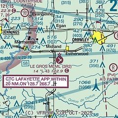
| Sectional chart |
|---|
|
| Airport distance calculator |
|---|
|
|
| Sunrise and sunset |
|---|
|
Times for 23-Jul-2026
| | Local
(UTC-5) | | Zulu
(UTC) |
|---|
| Morning civil twilight | | 05:58 | | 10:58 |
| Sunrise | | 06:24 | | 11:24 |
| Sunset | | 20:09 | | 01:09 |
| Evening civil twilight | | 20:35 | | 01:35 |
|
| Current date and time |
|---|
| Zulu (UTC) | 23-Jul-2026 14:56:24 |
|---|
| Local (UTC-5) | 23-Jul-2026 09:56:24 |
|---|
|
| METAR |
|---|
K3R7
11nm NW | 231435Z AUTO 09013G24KT 7SM BKN016 OVC024 28/25 A2984 RMK AO2 T02760246
|
|
| TAF |
|---|
KLFT
25nm E | 231348Z 2314/2412 10012G22KT 3SM -RA BKN013 FM231500 11013G24KT P6SM VCTS BKN016CB TEMPO 2316/2317 4SM -SHRA BR OVC015 FM231700 14014G24KT P6SM VCTS BKN020CB TEMPO 2317/2318 4SM -SHRA BR OVC015 FM240400 VRB04KT P6SM FEW250
|
|
| NOTAMs |
|---|
NOTAMs are issued by the DoD/FAA and will open in a separate window not controlled by AirNav.
|
|

