FAA INFORMATION EFFECTIVE 14 MAY 2026
Location
| FAA Identifier: | 4R7 |
| Lat/Long: | 30-27-58.6220N 092-25-25.6770W
30-27.977033N 092-25.427950W
30.4662839,-92.4237992
(estimated) |
| Elevation: | 42 ft. / 12.8 m (surveyed) |
| Variation: | 02E (2005) |
| From city: | 2 miles S of EUNICE, LA |
| Time zone: | UTC -5 (UTC -6 during Standard Time) |
| Zip code: | 70535 |
Airport Operations
| Airport use: | Open to the public |
| Activation date: | 09/1964 |
| Control tower: | no |
| ARTCC: | HOUSTON CENTER |
| FSS: | DE RIDDER FLIGHT SERVICE STATION |
| NOTAMs facility: | DRI (NOTAM-D service available) |
| Attendance: | MON-FRI 0800-1700, ALL SAT ON CALL, ALL SUN ON CALL |
| Wind indicator: | lighted |
| Segmented circle: | yes |
| Lights: | REIL RWY 16/34 AND MIRL RWY 16/34 PRESET LOW INTST DUSK-DAWN; TO INCR INTST ACTVT - CTAF. |
| Beacon: | white-green (lighted land airport)
Operates sunset to sunrise. |
Airport Communications
| CTAF/UNICOM: | 122.8 |
| LAFAYETTE APPROACH: | 128.7 |
| LAFAYETTE DEPARTURE: | 128.7 |
| WX AWOS-3PT at OPL (18 nm E): | 118.775 (337-948-8560) |
| WX AWOS-3PT at 3R7 (19 nm SW): | 121.150 (337-824-0517) |
- APCH/DEP SVC PRVDD BY HOUSTON ARTCC (ZHU) ON FREQS 126.35/338.25 (LAFAYETTE RCAG) WHEN LAFAYETTE (LFT) APCH CTL CLSD.
Nearby radio navigation aids
| VOR radial/distance | | VOR name | | Freq | | Var |
|---|
| LFTr303/27.7 | | LAFAYETTE VORTAC | | 109.80 | | 03E |
| NDB name | | Hdg/Dist | | Freq | | Var | | ID |
|---|
| ABBEVILLE | | 325/28.9 | | 230 | | 02E | | BNZ | -... -. --.. |
Airport Services
| Fuel available: | 100LL JET-A
100LL:FOR FUEL AFT HRS CALL 337-457-6585. |
| Parking: | hangars and tiedowns |
| Airframe service: | MINOR |
| Powerplant service: | MINOR |
| Bottled oxygen: | NONE |
| Bulk oxygen: | NONE |
Runway Information
Runway 16/34
| Dimensions: | 5001 x 75 ft. / 1524 x 23 m |
| Surface: | asphalt, in good condition |
| Weight bearing capacity: | |
| Runway edge lights: | medium intensity |
| Runway edge markings: | RUNWAY MARKINGS SEVERELY FADED |
| RUNWAY 16 | | RUNWAY 34 |
| Latitude: | 30-28.377583N | | 30-27.577350N |
| Longitude: | 092-25.544600W | | 092-25.312733W |
| Elevation: | 39.0 ft. | | 42.0 ft. |
| Traffic pattern: | left | | left |
| Runway heading: | 164 magnetic, 166 true | | 344 magnetic, 346 true |
| Markings: | nonprecision, in poor condition | | nonprecision, in poor condition |
| Visual slope indicator: | 2-light PAPI on left (3.00 degrees glide path)
RWY 16 PAPI UNUSBL BYD 6 DEGS LEFT OF CNTRLN. | | 2-light PAPI on left (3.00 degrees glide path) |
| Runway end identifier lights: | yes | | yes |
| Touchdown point: | yes, no lights | | yes, no lights |
| Obstructions: | 67 ft. trees, 1304 ft. from runway, 10 ft. right of centerline, 16:1 slope to clear | | 48 ft. trees, 1179 ft. from runway, 311 ft. left of centerline, 20:1 slope to clear |
Airport Ownership and Management from official FAA records
| Ownership: | Publicly-owned |
| Owner: | CITY OF EUNICE
PO BOX 1106
EUNICE, LA 70535
Phone 337-457-7389 |
| Manager: | DAVID KRESWELL
252 EUNICE AIRPORT ROAD
EUNICE, LA 70535
Phone 337-457-6585 |
Additional Remarks
| - | GCO AVBL ON FREQ 135.075 THRU LAFAYETTE APCH & DRI FSS. |
| - | FOR CD CTC LAFAYETTE APCH AT 337-262-2729, WHEN APCH CLSD CTC HOUSTON ARTCC AT 281-230-5622. |
| - | CTC APRT MGR FOR DSGND RAMP SPACE FOR PUB USE. |
Instrument Procedures
NOTE: All procedures below are presented as PDF files. If you need a reader for these files, you should download the free Adobe Reader.NOT FOR NAVIGATION. Please procure official charts for flight.
FAA instrument procedures published for use from 14 May 2026 at 0901Z to 11 June 2026 at 0900z.
IAPs - Instrument Approach Procedures |
|---|
| RNAV (GPS) RWY 16 | |
download (173KB) |
| RNAV (GPS) RWY 34 | |
download (169KB) |
| NOTE: Special Take-Off Minimums/Departure Procedures apply | |
download (326KB) |
Other nearby airports with instrument procedures:
KOPL - St Landry Parish Airport (18 nm E)
3R7 - Jennings Airport (19 nm SW)
KACP - Allen Parish Airport (22 nm NW)
6R1 - Welsh Airport (25 nm SW)
KLFT - Lafayette Regional Airport/Paul Fournet Field (27 nm SE)
|
|

Road maps at:
MapQuest
Bing
Google
| Aerial photo |
|---|
WARNING: Photo may not be current or correct
 Photo: Jay Powell, taken in a Cessna Cardinal
Do you have a better or more recent aerial photo of Eunice Airport that you would like to share? If so, please send us your photo.
|
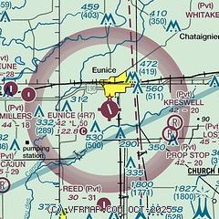
| Sectional chart |
|---|
|
| Airport distance calculator |
|---|
|
|
| Sunrise and sunset |
|---|
|
Times for 14-May-2026
| | Local
(UTC-5) | | Zulu
(UTC) |
|---|
| Morning civil twilight | | 05:51 | | 10:51 |
| Sunrise | | 06:17 | | 11:17 |
| Sunset | | 19:55 | | 00:55 |
| Evening civil twilight | | 20:21 | | 01:21 |
|
| Current date and time |
|---|
| Zulu (UTC) | 14-May-2026 21:06:11 |
|---|
| Local (UTC-5) | 14-May-2026 16:06:11 |
|---|
|
| METAR |
|---|
KOPL
18nm E | 142055Z AUTO 25003KT CLR 30/19 A2997 RMK AO2 T03000189 PWINO
|
K3R7
19nm SW | 142055Z AUTO 24005KT 10SM CLR 30/15 A2998 RMK AO2 T03030153
|
KACP
22nm NW | 142055Z AUTO 22005KT 10SM CLR 32/16 A2997 RMK AO2
|
KLFT
27nm SE | 142053Z 00000KT 10SM BKN050 BKN060 30/18 A2997 RMK AO2 SLP147 T03000183 58015
|
KIYA
34nm SE | 142055Z AUTO 15004KT 10SM FEW055 30/19 A2996 RMK AO2 T03030190 58014 $
|
K0R3
34nm SE | 118.875
No observation available
|
|
| TAF |
|---|
KLFT
27nm SE | 141720Z 1418/1518 VRB03KT P6SM FEW040 FM151200 00000KT 6SM BR SKC FM151600 18005KT P6SM SKC
|
|
| NOTAMs |
|---|
NOTAMs are issued by the DoD/FAA and will open in a separate window not controlled by AirNav.
|
|

