FAA INFORMATION EFFECTIVE 27 NOVEMBER 2025
Location
| FAA Identifier: | OPL |
| Lat/Long: | 30-33-30.2390N 092-05-57.7540W
30-33.503983N 092-05.962567W
30.5583997,-92.0993761
(estimated) |
| Elevation: | 74.3 ft. / 22.6 m (surveyed) |
| Variation: | 01E (2010) |
| From city: | 2 miles NW of OPELOUSAS, LA |
| Time zone: | UTC -6 (UTC -5 during Daylight Saving Time) |
| Zip code: | 70570 |
Airport Operations
| Airport use: | Open to the public |
| Activation date: | 10/1947 |
| Control tower: | no |
| ARTCC: | HOUSTON CENTER |
| FSS: | DE RIDDER FLIGHT SERVICE STATION |
| NOTAMs facility: | OPL (NOTAM-D service available) |
| Attendance: | MON-FRI 0800-1630, ALL SAT 0800-1200 |
| Wind indicator: | lighted |
| Segmented circle: | yes |
| Lights: | REIL RWY 18 & 36; MIRL RWY 18/36, PRESET LOW INTST DUSK-DAWN; TO INCR INTST ACTVT - CTAF. |
| Beacon: | white-green (lighted land airport)
Operates sunset to sunrise. |
Airport Communications
| CTAF/UNICOM: | 123.0 |
| WX AWOS-3PT: | 118.775 (337-948-8560) |
| LAFAYETTE APPROACH: | 128.7 |
| LAFAYETTE DEPARTURE: | 128.7 |
- APCH/DEP SVC PRVDD BY HOUSTON ARTCC ON FREQS 126.35/338.25 (LAFAYETTE RCAG) WHEN LAFAYETTE APCH CTL (LFT) CLSD.
Nearby radio navigation aids
| VOR radial/distance | | VOR name | | Freq | | Var |
|---|
| LFTr343/22.6 | | LAFAYETTE VORTAC | | 109.80 | | 03E |
| NDB name | | Hdg/Dist | | Freq | | Var | | ID |
|---|
| ABBEVILLE | | 000/29.9 | | 230 | | 02E | | BNZ | -... -. --.. |
Airport Services
| Fuel available: | 100LL JET-A+
100LL:CTC ARPT MGR FOR ACCEPTABLE FORMS OF PAYMENT FOR FUEL. |
| Parking: | hangars and tiedowns |
| Airframe service: | MINOR |
| Powerplant service: | MINOR |
Runway Information
Runway 18/36
| Dimensions: | 5999 x 100 ft. / 1828 x 30 m |
| Surface: | concrete, in good condition |
| Weight bearing capacity: | |
| Runway edge lights: | medium intensity |
| RUNWAY 18 | | RUNWAY 36 |
| Latitude: | 30-34.102487N | | 30-33.112943N |
| Longitude: | 092-05.932327W | | 092-05.935585W |
| Elevation: | 70.5 ft. | | 70.6 ft. |
| Traffic pattern: | right | | left |
| Runway heading: | 179 magnetic, 180 true | | 359 magnetic, 000 true |
| Displaced threshold: | 150 ft. | | 789 ft. |
| Markings: | nonprecision, in good condition | | nonprecision, in good condition |
| Visual slope indicator: | 2-light PAPI on left (3.50 degrees glide path) | | 2-light PAPI on left (3.50 degrees glide path) |
| Runway end identifier lights: | yes | | yes |
| Touchdown point: | yes, no lights | | yes, no lights |
| Obstructions: | 48 ft. tree, 943 ft. from runway, 114 ft. left of centerline, 15:1 slope to clear
APCH SLOPE 16:1 TO DSPLCD THLD. | | 19 ft. road, 307 ft. from runway, 5:1 slope to clear
APCH SLOPE 30:1 TO DSPLCD THLD. |
Runway 6/24
| Dimensions: | 4051 x 100 ft. / 1235 x 30 m |
| Surface: | concrete, in fair condition
RWY HAS SOME CRACKS WITH GRASS GROWING THRU CRACKS. |
| Weight bearing capacity: | |
| Runway edge markings: | RWY MARKINGS ARE FADED. |
| RUNWAY 6 | | RUNWAY 24 |
| Latitude: | 30-33.184108N | | 30-33.516655N |
| Longitude: | 092-06.339867W | | 092-05.669997W |
| Elevation: | 69.1 ft. | | 73.9 ft. |
| Traffic pattern: | left | | right |
| Runway heading: | 059 magnetic, 060 true | | 239 magnetic, 240 true |
| Displaced threshold: | 165 ft. | | 169 ft. |
| Markings: | basic, in poor condition | | basic, in poor condition |
| Touchdown point: | yes, no lights | | yes, no lights |
| Obstructions: | 46 ft. trees, 520 ft. from runway, 110 ft. left of centerline, 6:1 slope to clear
APCH RATIO 10:1 FM DSPLCD THLD. | | 56 ft. trees, 941 ft. from runway, 16 ft. left of centerline, 13:1 slope to clear
APCH RATIO 16:1 FM DSPLCD THLD. |
Airport Ownership and Management from official FAA records
| Ownership: | Publicly-owned |
| Owner: | ST. LANDRY PARISH GOVERNMENT
ST. LANDRY PARISH, P. O. DRAWER 1550
OPELOUSAS, LA 70571
Phone 337-948-3688 |
| Manager: | LLOYD ARDOIN
299 HANGAR RD.
OPELOUSAS, LA 70570
Phone 337-407-1551
AFTER HRS EMERG CELL 337-351-0025. |
Additional Remarks
| - | FOR CD CTC LAFAYETTE APCH AT 337-262-2729, WHEN APCH CLSD CTC HOUSTON ARTCC AT 281-230-5622. |
Instrument Procedures
NOTE: All procedures below are presented as PDF files. If you need a reader for these files, you should download the free Adobe Reader.NOT FOR NAVIGATION. Please procure official charts for flight.
FAA instrument procedures published for use from 27 November 2025 at 0901Z to 25 December 2025 at 0900Z.
IAPs - Instrument Approach Procedures |
|---|
| RNAV (GPS) RWY 18 | |
download (271KB) |
| RNAV (GPS) RWY 36 | |
download (267KB) |
| VOR RWY 36 | |
download (204KB) |
| NOTE: Special Alternate Minimums apply | |
download (161KB) |
| NOTE: Special Take-Off Minimums/Departure Procedures apply | |
download (326KB) |
Other nearby airports with instrument procedures:
4R7 - Eunice Airport (18 nm W)
KLFT - Lafayette Regional Airport/Paul Fournet Field (22 nm S)
2R6 - Bunkie Municipal Airport (25 nm N)
KMKV - Marksville Municipal Airport (32 nm N)
KACP - Allen Parish Airport (33 nm W)
|
|

Road maps at:
MapQuest
Bing
Google
| Aerial photo |
|---|
WARNING: Photo may not be current or correct
 Photo taken 17-Sep-2019
looking north.
Photo taken 17-Sep-2019
looking north.
Do you have a better or more recent aerial photo of St Landry Parish Airport that you would like to share? If so, please send us your photo.
|
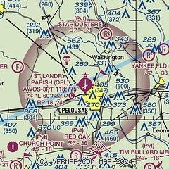
| Sectional chart |
|---|
|
| Airport distance calculator |
|---|
|
|
| Sunrise and sunset |
|---|
|
Times for 24-Dec-2025
| | Local
(UTC-6) | | Zulu
(UTC) |
|---|
| Morning civil twilight | | 06:37 | | 12:37 |
| Sunrise | | 07:04 | | 13:04 |
| Sunset | | 17:12 | | 23:12 |
| Evening civil twilight | | 17:39 | | 23:39 |
|
| Current date and time |
|---|
| Zulu (UTC) | 24-Dec-2025 11:19:34 |
|---|
| Local (UTC-6) | 24-Dec-2025 05:19:34 |
|---|
|
| METAR |
|---|
| KOPL | 241055Z AUTO 00000KT 1/4SM FG OVC003 12/11 A3029 RMK AO2 T01170112
|
|
| TAF |
|---|
KLFT
22nm S | 240538Z 2406/2506 00000KT 5SM BR FEW250 FM240800 00000KT 1SM BR SCT250 FM240900 00000KT 1/4SM FG BKN001 FM241700 VRB04KT P6SM BKN004 FM241900 VRB05KT P6SM SCT018 FM250500 00000KT 2SM BR SCT250
|
|
| NOTAMs |
|---|
NOTAMs are issued by the DoD/FAA and will open in a separate window not controlled by AirNav.
|
|

