FAA INFORMATION EFFECTIVE 25 DECEMBER 2025
Location
| FAA Identifier: | 6R3 |
| Lat/Long: | 30-21-23.2000N 095-00-28.9000W
30-21.386667N 095-00.481667W
30.3564444,-95.0080278
(estimated) |
| Elevation: | 150.1 ft. / 45.8 m (surveyed) |
| Variation: | 05E (1995) |
| From city: | 4 miles NE of CLEVELAND, TX |
| Time zone: | UTC -6 (UTC -5 during Daylight Saving Time) |
| Zip code: | 77327 |
Airport Operations
| Airport use: | Open to the public |
| Activation date: | 11/1969 |
| Control tower: | no |
| ARTCC: | HOUSTON CENTER |
| FSS: | MONTGOMERY COUNTY FLIGHT SERVICE STATION |
| NOTAMs facility: | CXO (NOTAM-D service available) |
| Attendance: | M-S 0800-1800, ALL SUN 1300-1800 |
| Wind indicator: | lighted |
| Segmented circle: | yes |
| Lights: | ACTVT PAPI RWY 16 & 34; MIRL RWY 16/34 - CTAF. |
| Beacon: | white-green (lighted land airport)
Operates sunset to sunrise. |
Airport Communications
| CTAF/UNICOM: | 123.0 |
| WX AWOS-3: | 119.325 (281-593-1754) |
| HOUSTON APPROACH: | 119.7 |
| HOUSTON DEPARTURE: | 119.7 |
| BLTWY RNAV DP: | 119.7 |
| BORRN RNAV DP: | 119.7 |
| DREMR DP: | 119.7 |
| HOODO RNAV DP: | 119.7 |
| HUDZY STAR: | 120.05 |
| INDIE RNAV DP: | 119.7 |
| KARRR RNAV DP: | 119.7 |
| LURIC RNAV DP: | 119.7 |
| MMALT RNAV DP: | 119.7 |
| OHIIO STAR: | 120.05 |
| PIEGY RNAV STAR: | 119.7 |
| RIICE STAR: | 124.35 |
| STRYA DP: | 119.7 |
| STYCK DP: | 119.7 |
| WATFO DP: | 119.7 |
| WYLSN RNAV DP: | 119.7 |
Nearby radio navigation aids
| VOR radial/distance | | VOR name | | Freq | | Var |
|---|
| DASr293/21.3 | | DAISETTA VORTAC | | 116.90 | | 05E |
| IAHr031/29.7 | | HUMBLE VORTAC | | 116.60 | | 05E |
Airport Services
| Fuel available: | 100LL JET-A+ |
| Parking: | tiedowns |
| Airframe service: | MAJOR |
| Powerplant service: | MAJOR |
| Bottled oxygen: | NONE |
| Bulk oxygen: | NONE |
Runway Information
Runway 16/34
| Dimensions: | 5001 x 75 ft. / 1524 x 23 m |
| Surface: | asphalt, in good condition |
| Weight bearing capacity: | |
| Runway edge lights: | medium intensity |
| RUNWAY 16 | | RUNWAY 34 |
| Latitude: | 30-21.777720N | | 30-20.994715N |
| Longitude: | 095-00.630152W | | 095-00.332567W |
| Elevation: | 150.0 ft. | | 141.5 ft. |
| Traffic pattern: | left | | left |
| Runway heading: | 157 magnetic, 162 true | | 337 magnetic, 342 true |
| Markings: | nonprecision, in good condition | | nonprecision, in good condition |
| Visual slope indicator: | 4-light PAPI on left (3.00 degrees glide path) | | 4-light PAPI on left (3.00 degrees glide path) |
| Touchdown point: | yes, no lights | | yes, no lights |
| Obstructions: | 32 ft. trees, 201 ft. from runway, 240 ft. right of centerline
32 FT TREES 0-199 FT DSTC,- 240 FT RIGHT. | | 72 ft. trees, 1300 ft. from runway, 15:1 slope to clear |
Airport Ownership and Management from official FAA records
| Ownership: | Publicly-owned |
| Owner: | CITY OF CLEVELAND
907 E. HOUSTON ST
CLEVELAND, TX 77327
Phone 281-592-1282 |
| Manager: | DICKIE HARBOUR
17699 HIGHWAY 787 W.
CLEVELAND, TX 77327
Phone 281-592-1282 |
Additional Remarks
| - | TO ACCESS AIRPORT SECURITY GATE USE UNICOM FREQUENCY. |
| - | +25 FT TREES 260 FT WEST OF CNTRLN AT THR. |
| - | FOR SVC AFT HRS CALL 281-761-5012. |
| - | FOR CD CTC HOUSTON APCH AT 281-443-5844 TO CNL IFR CALL 281-443-5888. |
| - | RWY 16 CALM WIND RWY. |
Instrument Procedures
NOTE: All procedures below are presented as PDF files. If you need a reader for these files, you should download the free Adobe Reader.NOT FOR NAVIGATION. Please procure official charts for flight.
FAA instrument procedures published for use from 25 December 2025 at 0901z to 22 January 2026 at 0900z.
STARs - Standard Terminal Arrivals |
|---|
| BAZBL ONE (RNAV) | |
download (254KB) |
| HUDZY FIVE | |
2 pages:
[1] [2] (281KB) |
| OHIIO FOUR | |
download (265KB) |
| PIEGY ONE (RNAV) | |
download (134KB) |
| RIICE ONE | |
2 pages:
[1] [2] (504KB) |
IAPs - Instrument Approach Procedures |
|---|
| RNAV (GPS) RWY 16 | |
download (197KB) |
| NOTE: Special Alternate Minimums apply | |
download (125KB) |
Departure Procedures |
|---|
| BLTWY SEVEN (RNAV) | |
download (150KB) |
| BORRN SIX (RNAV) | |
2 pages:
[1] [2] (300KB) |
| HOODO SEVEN (RNAV) | |
download (192KB) |
| INDIE EIGHT (RNAV) | |
download (178KB) |
| KARRR SEVEN (RNAV) | |
2 pages:
[1] [2] (249KB) |
| LURIC EIGHT (RNAV) | |
download (200KB) |
| MMALT SEVEN (RNAV) | |
download (210KB) |
| STRYA EIGHT (RNAV) | |
download (188KB) |
| STYCK EIGHT (RNAV) | |
download (175KB) |
| WATFO SIX (RNAV) | |
download (164KB) |
| WYLSN EIGHT (RNAV) | |
download (162KB) |
| NOTE: Special Take-Off Minimums/Departure Procedures apply | |
download (70KB) |
Other nearby airports with instrument procedures:
00R - Livingston Municipal Airport (20 nm N)
KCXO - Conroe/North Houston Regional Airport (21 nm W)
T78 - Liberty Municipal Airport (23 nm SE)
KIAH - George Bush Intercontinental/Houston Airport (28 nm SW)
KDWH - David Wayne Hooks Memorial Airport (33 nm SW)
|
|

Road maps at:
MapQuest
Bing
Google
| Aerial photo |
|---|
WARNING: Photo may not be current or correct

Do you have a better or more recent aerial photo of Cleveland Municipal Airport that you would like to share? If so, please send us your photo.
|
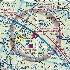
| Sectional chart |
|---|
|
| Airport distance calculator |
|---|
|
|
| Sunrise and sunset |
|---|
|
Times for 09-Jan-2026
| | Local
(UTC-6) | | Zulu
(UTC) |
|---|
| Morning civil twilight | | 06:53 | | 12:53 |
| Sunrise | | 07:19 | | 13:19 |
| Sunset | | 17:36 | | 23:36 |
| Evening civil twilight | | 18:02 | | 00:02 |
|
| Current date and time |
|---|
| Zulu (UTC) | 10-Jan-2026 05:39:05 |
|---|
| Local (UTC-6) | 09-Jan-2026 23:39:05 |
|---|
|
| METAR |
|---|
| K6R3 | 100515Z AUTO 00000KT 5SM BR SCT017 SCT029 BKN050 21/20 A2999 RMK AO2 LTG DSNT ALQDS T02100198
|
|
| TAF |
|---|
KCXO
21nm W | 100309Z 1003/1024 VRB03KT 2SM BR VCTS FEW022 SCT030CB BKN050 TEMPO 1003/1006 VRB05G15KT 4SM TSRA BKN030CB FM100600 33005KT 6SM BR OVC015 FM100800 34007KT P6SM BKN250 FM101400 34015G25KT P6SM BKN250
|
|
| NOTAMs |
|---|
NOTAMs are issued by the DoD/FAA and will open in a separate window not controlled by AirNav.
|
|

