FAA INFORMATION EFFECTIVE 15 MAY 2025
Location
| FAA Identifier: | 6S8 |
| Lat/Long: | 45-42-18.6416N 108-45-38.7760W
45-42.310693N 108-45.646267W
45.7051782,-108.7607711
(estimated) |
| Elevation: | 3542.6 ft. / 1079.8 m (surveyed) |
| Variation: | 14E (1990) |
| From city: | 2 miles N of LAUREL, MT |
| Time zone: | UTC -6 (UTC -7 during Standard Time) |
| Zip code: | 59106 |
Airport Operations
| Airport use: | Open to the public |
| Activation date: | 07/1954 |
| Control tower: | no |
| ARTCC: | SALT LAKE CITY CENTER |
| FSS: | GREAT FALLS FLIGHT SERVICE STATION |
| NOTAMs facility: | GTF (NOTAM-D service available) |
| Attendance: | MON-FRI 0800-1700, ALL SAT-SUN INTERMITTANT |
| Wind indicator: | lighted |
| Segmented circle: | yes |
| Lights: | ACTVT PAPI RWY 04 & 22 & 14 & 32; MIRL RWY 04/22 & 14/32 - CTAF. |
| Beacon: | white-green (lighted land airport)
Operates sunset to sunrise. |
Airport Communications
| CTAF/UNICOM: | 123.05 |
| WX AWOS-2: | 135.05 (406-628-9867) |
| BILLINGS APPROACH: | 119.2 120.5 |
| BILLINGS DEPARTURE: | 119.2 120.5 |
| WX ASOS at BIL (11 nm NE): | 126.3 (406-503-0719) |
Nearby radio navigation aids
| VOR radial/distance | | VOR name | | Freq | | Var |
|---|
| BILr209/8.4 | | BILLINGS VORTAC | | 114.50 | | 14E |
Airport Services
| Fuel available: | 100LL JET-A |
| Parking: | hangars and tiedowns |
| Airframe service: | MINOR |
| Powerplant service: | MINOR |
| Bottled oxygen: | NONE |
| Bulk oxygen: | NONE |
Runway Information
Runway 4/22
| Dimensions: | 5199 x 75 ft. / 1585 x 23 m |
| Surface: | asphalt, in good condition |
| Weight bearing capacity: | |
| Runway edge lights: | medium intensity |
| RUNWAY 4 | | RUNWAY 22 |
| Latitude: | 45-42.097523N | | 45-42.644203N |
| Longitude: | 108-45.838160W | | 108-44.899487W |
| Elevation: | 3487.8 ft. | | 3454.4 ft. |
| Traffic pattern: | left | | left |
| Runway heading: | 036 magnetic, 050 true | | 216 magnetic, 230 true |
| Markings: | nonprecision, in fair condition | | nonprecision, in fair condition |
| Visual slope indicator: | 2-light PAPI on left (3.00 degrees glide path) | | 2-light PAPI on left (3.00 degrees glide path) |
| Touchdown point: | yes, no lights | | yes, no lights |
Runway 14/32
| Dimensions: | 3002 x 60 ft. / 915 x 18 m |
| Surface: | asphalt, in good condition |
| Weight bearing capacity: | |
| Runway edge lights: | medium intensity |
| RUNWAY 14 | | RUNWAY 32 |
| Latitude: | 45-42.448138N | | 45-42.010523N |
| Longitude: | 108-46.202073W | | 108-45.875610W |
| Elevation: | 3542.6 ft. | | 3482.6 ft. |
| Traffic pattern: | left | | left |
| Runway heading: | 138 magnetic, 152 true | | 318 magnetic, 332 true |
| Markings: | basic, in good condition | | basic, in good condition |
| Visual slope indicator: | 2-light PAPI on left (4.00 degrees glide path) | | 2-light PAPI on left (3.00 degrees glide path) |
| Touchdown point: | yes, no lights | | yes, no lights |
Runway 9/27
| Dimensions: | 1100 x 60 ft. / 335 x 18 m |
| Surface: | turf, in fair condition |
| Runway edge markings: | 09/27 MARKER CONES FULL RY LENGTH. |
| RUNWAY 9 | | RUNWAY 27 |
| Latitude: | 45-42.259783N | | 45-42.236917N |
| Longitude: | 108-46.014367W | | 108-45.758017W |
| Elevation: | 3511.0 ft. | | 3484.5 ft. |
| Traffic pattern: | left | | left |
| Runway heading: | 084 magnetic, 098 true | | 264 magnetic, 278 true |
| Touchdown point: | yes, no lights | | yes, no lights |
Airport Ownership and Management from official FAA records
| Ownership: | Publicly-owned |
| Owner: | AIRPORT AUTHORITY
BOX 242
LAUREL, MT 59044
Phone 406-628-0172 |
| Manager: | AIRPORT BOARD
PO BOX 242
LAUREL, MT 59044
Phone 406-628-0172 |
Additional Remarks
| - | FOR CD CTC BILLINGS APCH AT 406-255-2798 |
| - | NUMEROUS DEER AND ANTELOPE ON AND INVOF OF RY. |
| - | RY 09/27 NOT MAINTAINED DURG WINTER. |
| - | INTMT SNOW REMOVAL- BE ALERT DURING WINTER MONTHS. |
Instrument Procedures
NOTE: All procedures below are presented as PDF files. If you need a reader for these files, you should download the free Adobe Reader.NOT FOR NAVIGATION. Please procure official charts for flight.
FAA instrument procedures published for use from 15 May 2025 at 0901Z to 13 June 2025 at 0900z.
IAPs - Instrument Approach Procedures |
|---|
| RNAV (GPS) RWY 04 | |
download (232KB) |
| RNAV (GPS) RWY 22 | |
download (240KB) |
| VOR RWY 22 | |
download (258KB) |
| NOTE: Special Alternate Minimums apply | |
download (186KB) |
Departure Procedures |
|---|
| BILLINGS FIVE | |
download (228KB) |
| NOTE: Special Take-Off Minimums/Departure Procedures apply | |
download (238KB) |
Other nearby airports with instrument procedures:
KBIL - Billings Logan International Airport (11 nm NE)
00U - Big Horn County Airport (46 nm E)
KRPX - Roundup Airport (47 nm N)
U68 - North Big Horn County Airport (49 nm S)
KPOY - Powell Municipal Airport (50 nm S)
|
|

Road maps at:
MapQuest
Bing
Google
| Aerial photo |
|---|
WARNING: Photo may not be current or correct

Do you have a better or more recent aerial photo of Laurel Municipal Airport that you would like to share? If so, please send us your photo.
|
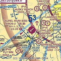
| Sectional chart |
|---|
|
| Airport distance calculator |
|---|
|
|
| Sunrise and sunset |
|---|
|
Times for 05-Jun-2025
| | Local
(UTC-6) | | Zulu
(UTC) |
|---|
| Morning civil twilight | | 04:50 | | 10:50 |
| Sunrise | | 05:28 | | 11:28 |
| Sunset | | 20:59 | | 02:59 |
| Evening civil twilight | | 21:37 | | 03:37 |
|
| Current date and time |
|---|
| Zulu (UTC) | 05-Jun-2025 11:37:05 |
|---|
| Local (UTC-6) | 05-Jun-2025 05:37:05 |
|---|
|
| METAR |
|---|
KBIL
10nm NE | 051053Z 22003KT 10SM FEW060 FEW120 SCT200 09/05 A3008 RMK AO2 SLP175 T00890050 $
|
|
| TAF |
|---|
KBIL
10nm NE | 050522Z 0506/0606 VRB06KT P6SM SCT100 BKN200 FM051700 07005KT P6SM SCT080 BKN250 FM060200 VRB06KT P6SM SCT070 SCT250
|
|
| NOTAMs |
|---|
NOTAMs are issued by the DoD/FAA and will open in a separate window not controlled by AirNav.
|
|


