FAA INFORMATION EFFECTIVE 22 JANUARY 2026
Location
| FAA Identifier: | 74N |
| Lat/Long: | 40-33-32.3850N 076-33-34.9650W
40-33.539750N 076-33.582750W
40.5589958,-76.5597125
(estimated) |
| Elevation: | 790.6 ft. / 241 m (estimated) |
| Variation: | 11W (2010) |
| From city: | 2 miles S of TOWER CITY, PA |
| Time zone: | UTC -5 (UTC -4 during Daylight Saving Time) |
| Zip code: | 17980 |
Airport Operations
| Airport use: | Open to the public |
| Activation date: | 12/1949 |
| Control tower: | no |
| ARTCC: | NEW YORK CENTER |
| FSS: | WILLIAMSPORT FLIGHT SERVICE STATION |
| NOTAMs facility: | IPT (NOTAM-D service available) |
| Attendance: | UNATTENDED UNATTENDED |
| Wind indicator: | lighted |
| Segmented circle: | no |
| Lights: | ACTVT MIRL RWY 05/23 - CTAF. |
| Beacon: | white-green (lighted land airport) |
Airport Communications
| CTAF: | 122.9 |
| HARRISBURG APPROACH: | 126.45 |
| HARRISBURG DEPARTURE: | 126.45 |
| WX ASOS at MUI (7 nm S): | 124.175 (717-861-6493) |
| WX AWOS-3 at ZER (12 nm NE): | 127.575 (570-544-2778) |
| WX AWOS-2 at 9D4 (16 nm SE): | 118.45 (717-866-2906) |
| WX AWOS-3 at N79 (17 nm N): | 119.175 (570-672-0389) |
Nearby radio navigation aids
| VOR radial/distance | | VOR name | | Freq | | Var |
|---|
| RAVr090/1.8 | | RAVINE VORTAC | | 114.60 | | 11W |
| SEGr141/20.3 | | SELINSGROVE VOR/DME | | 110.40 | | 08W |
| HARr067/27.9 | | HARRISBURG VORTAC | | 115.35 | | 10W |
| MIPr179/28.3 | | MILTON VORTAC | | 109.20 | | 09W |
| LRPr344/29.1 | | LANCASTER VOR/DME | | 117.30 | | 09W |
| ETXr277/39.9 | | EAST TEXAS VOR/DME | | 110.20 | | 09W |
| NDB name | | Hdg/Dist | | Freq | | Var | | ID |
|---|
| BELLGROVE | | 008/7.4 | | 328 | | 10W | | BZJ | -... --.. .--- |
Airport Services
| Parking: | tiedowns |
| Bottled oxygen: | NONE |
| Bulk oxygen: | NONE |
Runway Information
Runway 5/23
| Dimensions: | 2325 x 60 ft. / 709 x 18 m |
| Surface: | asphalt/concrete, in good condition |
| Weight bearing capacity: | |
| Runway edge lights: | medium intensity |
| RUNWAY 5 | | RUNWAY 23 |
| Latitude: | 40-33.398833N | | 40-33.680667N |
| Longitude: | 076-33.752667W | | 076-33.412833W |
| Elevation: | 785.6 ft. | | 790.6 ft. |
| Traffic pattern: | left | | left |
| Runway heading: | 053 magnetic, 042 true | | 233 magnetic, 222 true |
| Displaced threshold: | no | | 181 ft. |
| Markings: | basic, in good condition | | nonprecision, in good condition |
| Visual slope indicator: | | | 2-box VASI on right (3.00 degrees glide path)
VASI OTS INDEFLY. |
| Touchdown point: | yes, no lights | | yes, no lights |
| Obstructions: | 34 ft. trees, 710 ft. from runway, 12 ft. right of centerline, 15:1 slope to clear | | 23 ft. tree, 441 ft. from runway, 135 ft. left of centerline, 10:1 slope to clear
APCH RATIO 28:1 TO DTHR. |
Airport Ownership and Management from official FAA records
| Ownership: | Privately-owned |
| Owner: | GENE BENDIGO & HELEN BENDIGO TRUST
11079 CLARKS VALLEY RD
TOWER CITY, PA 17980
Phone 610-413-7428 |
| Manager: | PAUL BENDIGO
250 DICKINSON DR.
READING, PA 17605
Phone 610-413-7428 |
Additional Remarks
| A30A-05 | CLSD DLY SS-SR. |
| - | 160 FT LGHTD TWR 400 FT N OF RWY MIDFIELD. |
| - | RAPIDLY RISING TRRN 1500 MSL N-NW OF RWY 5. MT RIDGE 1500 MSL 1 NM S OF ARPT PARALLEL TO RWY 5/23. |
| - | FOR CD CTC HARRISBURG APCH AT 800-932-0712. |
| - | DEER AND WILDLIFE ON & INVOF ARPT. |
Instrument Procedures
NOTE: All procedures below are presented as PDF files. If you need a reader for these files, you should download the free Adobe Reader.NOT FOR NAVIGATION. Please procure official charts for flight.
FAA instrument procedures published for use from 22 January 2026 at 0901Z to 19 February 2026 at 0900z.
IAPs - Instrument Approach Procedures |
|---|
| RNAV (GPS)-A | |
download (175KB) |
| NOTE: Special Take-Off Minimums/Departure Procedures apply | |
download (149KB) |
Other nearby airports with instrument procedures:
KMUI - Muir (Fort Indiantown Gap) Army Heliport (7 nm S)
KZER - Schuylkill County/Joe Zerbey Airport (12 nm NE)
9D4 - Deck Airport (16 nm SE)
58N - Reigle Field Airport (16 nm S)
N79 - Northumberland County Airport (17 nm N)
08N - Keller Brothers Airport (19 nm SE)
|
|

Road maps at:
MapQuest
Bing
Google
| Aerial photo |
|---|
WARNING: Photo may not be current or correct
 Photo by Paul Bendigo
Photo taken 10-Aug-2013
looking west.
Photo by Paul Bendigo
Photo taken 10-Aug-2013
looking west.
Do you have a better or more recent aerial photo of Bendigo Airport that you would like to share? If so, please send us your photo.
|
| Sectional chart |
|---|
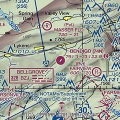
|
| Airport distance calculator |
|---|
|
|
| Sunrise and sunset |
|---|
|
Times for 04-Feb-2026
| | Local
(UTC-5) | | Zulu
(UTC) |
|---|
| Morning civil twilight | | 06:45 | | 11:45 |
| Sunrise | | 07:14 | | 12:14 |
| Sunset | | 17:26 | | 22:26 |
| Evening civil twilight | | 17:55 | | 22:55 |
|
| Current date and time |
|---|
| Zulu (UTC) | 04-Feb-2026 23:49:52 |
|---|
| Local (UTC-5) | 04-Feb-2026 18:49:52 |
|---|
|
| METAR |
|---|
KMUI
9nm S | 042255Z 32004KT 10SM BKN250 M02/M14 A3020 RMK AO2A SLP236 T10241139
|
KZER
12nm NE | 042335Z AUTO 31004KT 10SM CLR M07/M14 A3014 RMK AO2
|
|
| TAF |
|---|
KMUI
9nm S | 041900Z 0419/0601 34009KT 9999 SCT015 BKN230 QNH3020INS BECMG 0507/0508 35009KT 9999 SCT020 QNH3015INS BECMG 0518/0519 34009KT 9999 BKN015 OVC025 620153 QNH3001INS TX00/0419Z TNM10/0504Z
|
|
| NOTAMs |
|---|
NOTAMs are issued by the DoD/FAA and will open in a separate window not controlled by AirNav.
|
|

