FAA INFORMATION EFFECTIVE 17 APRIL 2025
Location
| FAA Identifier: | 79D |
| Lat/Long: | 39-09-58.2850N 080-03-44.4550W
39-09.971417N 080-03.740917W
39.1661903,-80.0623486
(estimated) |
| Elevation: | 1755.4 ft. / 535 m (estimated) |
| Variation: | 09W (2010) |
| From city: | 2 miles NW of PHILIPPI, WV |
| Time zone: | UTC -4 (UTC -5 during Standard Time) |
| Zip code: | 26416 |
Airport Operations
| Airport use: | Open to the public |
| Activation date: | 10/1973 |
| Control tower: | no |
| ARTCC: | WASHINGTON CENTER |
| FSS: | ELKINS FLIGHT SERVICE STATION [703-724-4288] |
| NOTAMs facility: | EKN (NOTAM-D service available) |
| Attendance: | UNATNDD |
| Wind indicator: | lighted |
| Segmented circle: | yes |
| Lights: | DUSK-DAWN. ACTIVATE REIL RWY 08; PAPI RWYS 08 & 26; MIRL RWY 08/26 - CTAF. |
| Beacon: | white-green (lighted land airport)
Operates sunset to sunrise. |
Airport Communications
| CTAF: | 122.9 |
| CLARKSBURG APPROACH: | 121.15 |
| CLARKSBURG DEPARTURE: | 121.15 |
| WX ASOS at CKB (11 nm NW): | PHONE 304-842-9240 |
| WX AWOS-3 at W22 (14 nm SW): | 119.975 (304-472-9428) |
| WX ASOS at EKN (19 nm SE): | 119.275 (304-636-5603) |
- APCH/DEP SVC PRVDD BY WASHINGTON ARTCC ON FREQS 128.6/226.675 (ELKINS RCAG) WHEN CLARKSBURG APCH CTL CLSD.
Nearby radio navigation aids
| VOR radial/distance | | VOR name | | Freq | | Var |
|---|
| CKBr123/10.9 | | CLARKSBURG VOR/DME | | 112.60 | | 04W |
| EKNr013/15.2 | | ELKINS VORTAC | | 114.20 | | 07W |
| MGWr207/25.2 | | MORGANTOWN VOR/DME | | 111.60 | | 05W |
| NDB name | | Hdg/Dist | | Freq | | Var | | ID |
|---|
| RANDOLPH COUNTY | | 337/18.9 | | 284 | | 07W | | RQY | .-. --.- -.-- |
Airport Services
| Fuel available: | 100LL
100LL:24 HR. SELF SERVE. |
| Parking: | tiedowns |
| Airframe service: | NONE |
| Powerplant service: | NONE |
| Bottled oxygen: | NONE |
| Bulk oxygen: | NONE |
Runway Information
Runway 8/26
| Dimensions: | 3275 x 60 ft. / 998 x 18 m |
| Surface: | asphalt, in good condition |
| Runway edge lights: | medium intensity |
| RUNWAY 8 | | RUNWAY 26 |
| Latitude: | 39-09.896333N | | 39-10.046500N |
| Longitude: | 080-04.073833W | | 080-03.408000W |
| Elevation: | 1713.1 ft. | | 1755.4 ft. |
| Traffic pattern: | left | | left |
| Runway heading: | 083 magnetic, 074 true | | 263 magnetic, 254 true |
| Displaced threshold: | 140 ft. | | 225 ft. |
| Markings: | basic, in fair condition | | basic, in fair condition |
| Visual slope indicator: | 2-light PAPI on left (3.00 degrees glide path) | | 2-light PAPI on left (3.00 degrees glide path) |
| Runway end identifier lights: | yes
OMNIDIRECTIONAL REILS. | | no |
| Touchdown point: | yes, no lights | | yes, no lights |
| Obstructions: | 20 ft. tree, 208 ft. from runway, 70 ft. left of centerline
20 FT TREES, 0-120 FT DSTC, 45 FT L. | | 156 ft. gnd, 3200 ft. from runway, 550 ft. right of centerline, 19:1 slope to clear
20 FT TREES 0-30 FT DSTC 50 FT R/L. |
Airport Ownership and Management from official FAA records
| Ownership: | Publicly-owned |
| Owner: | PHILIPPI/BARBOUR CO. ARPT AUTHORITY
26 N. MAIN ST.
PHILIPPI, WV 26416
Phone 304-457-4339
EXT 2 |
| Manager: | VERLE BROWN
26 N. MAIN ST
PHILIPPI, WV 26416
Phone 304-695-0125 |
Additional Remarks
| - | RWY 26 500 FT DROP-OFF 50 FT FM THR. |
| - | RWY 08 150 FT DROP-OFF 112 FT FM THR. |
| - | WILDLIFE INVOF ARPT. |
| - | AIRPORT FENCED. VEHICLE GATE LOCKED. ONLY ACCESS VIA PEDESTRIAN GATE. |
| - | FOR CD CTC WASHINGTON ARTCC AT 703-771-3587. |
Instrument Procedures
NOTE: All procedures below are presented as PDF files. If you need a reader for these files, you should download the free Adobe Reader.NOT FOR NAVIGATION. Please procure official charts for flight.
FAA instrument procedures published for use from 17 April 2025 at 0901Z to 15 May 2025 at 0900z.
IAPs - Instrument Approach Procedures |
|---|
| RNAV (GPS) RWY 26 | |
download (209KB) |
| NOTE: Special Take-Off Minimums/Departure Procedures apply | |
download (149KB) |
Other nearby airports with instrument procedures:
KCKB - North Central West Virginia Airport (11 nm NW)
W22 - Upshur County Regional Airport (14 nm SW)
4G7 - Fairmont Municipal Airport-Frankman Field (18 nm N)
KEKN - Elkins-Randolph County Airport-Jennings Randolph Field (19 nm SE)
KMGW - Morgantown Municipal Airport/Walter L Bill Hart Field (29 nm N)
|
|

Road maps at:
MapQuest
Bing
Google
| Aerial photo |
|---|
WARNING: Photo may not be current or correct
 Photo by James Arnold
Photo taken 04-Mar-2018
looking northwest.
Photo by James Arnold
Photo taken 04-Mar-2018
looking northwest.
Do you have a better or more recent aerial photo of Philippi/Barbour County Regional Airport that you would like to share? If so, please send us your photo.
|
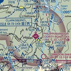
| Sectional chart |
|---|
|
| Airport distance calculator |
|---|
|
|
| Sunrise and sunset |
|---|
|
Times for 25-Apr-2025
| | Local
(UTC-4) | | Zulu
(UTC) |
|---|
| Morning civil twilight | | 06:02 | | 10:02 |
| Sunrise | | 06:31 | | 10:31 |
| Sunset | | 20:06 | | 00:06 |
| Evening civil twilight | | 20:34 | | 00:34 |
|
| Current date and time |
|---|
| Zulu (UTC) | 25-Apr-2025 20:51:25 |
|---|
| Local (UTC-4) | 25-Apr-2025 16:51:25 |
|---|
|
| METAR |
|---|
KCKB
11nm NW | 251953Z 20009G20KT 10SM -RA FEW033 BKN065 OVC110 20/16 A3002 RMK AO2 RAB16 SLP154 P0008 T02000161
|
KW22
14nm SW | 252030Z AUTO 19005KT 10SM FEW007 FEW010 19/19 A3005 RMK AO2
|
KEKN
20nm SE | 252007Z AUTO 10003KT 10SM -RA FEW043 BKN080 OVC090 17/17 A3009 RMK AO2 LTG DSNT E P0000 T01720167
|
|
| TAF |
|---|
KCKB
11nm NW | 251720Z 2518/2618 21006KT P6SM -SHRA VCTS OVC045CB TEMPO 2520/2523 3SM -TSRA OVC030CB FM252300 20005KT 6SM SHRA BR VCTS OVC030CB FM260300 20006KT 3SM SHRA BR VCTS OVC015CB FM260600 21007KT 3SM -SHRA BR OVC007 FM261200 26006KT 5SM -SHRA BKN011 FM261500 28008G16KT P6SM BKN012
|
KEKN
20nm SE | 251720Z 2518/2618 21005KT P6SM -SHRA VCTS OVC045CB TEMPO 2519/2523 4SM -TSRA BR OVC025CB FM252300 20004KT 4SM SHRA BR VCTS OVC030CB FM260300 VRB03KT 3SM -SHRA BR OVC016 FM260800 23005KT 5SM -SHRA BR BKN010 FM261500 28008G16KT P6SM -SHRA BKN012
|
|
| NOTAMs |
|---|
NOTAMs are issued by the DoD/FAA and will open in a separate window not controlled by AirNav.
|
|


