FAA INFORMATION EFFECTIVE 22 JANUARY 2026
Location
| FAA Identifier: | 80T |
| Lat/Long: | 47-12-41.8000N 119-50-23.4000W
47-12.696667N 119-50.390000W
47.2116111,-119.8398333
(estimated) |
| Elevation: | 1271.1 ft. / 387.4 m (surveyed) |
| Variation: | 20E (1985) |
| From city: | 2 miles SE of QUINCY, WA |
| Time zone: | UTC -8 (UTC -7 during Daylight Saving Time) |
| Zip code: | 98848 |
Airport Operations
| Airport use: | Open to the public |
| Activation date: | 03/1979 |
| Control tower: | no |
| ARTCC: | SEATTLE CENTER |
| FSS: | SEATTLE FLIGHT SERVICE STATION |
| NOTAMs facility: | SEA (NOTAM-D service available) |
| Attendance: | UNATNDD |
| Wind indicator: | lighted |
| Segmented circle: | no |
| Lights: | SS-SR |
| Beacon: | white-green (lighted land airport)
Operates sunset to sunrise. |
Airport Communications
| CTAF: | 122.9 |
| WX ASOS at EPH (14 nm NE): | 135.775 (509-754-3761) |
| WX ASOS at EAT (19 nm NW): | 119.925 (509-886-4226) |
- APCH/DEP SVC PRVDD BY SEATTLE ARTCC ON FREQS 126.1/291.6 (MARLIN RCAG) WHEN GRANT COUNTY APCH CTL CLSD.
Nearby radio navigation aids
| VOR radial/distance | | VOR name | | Freq | | Var |
|---|
| EATr112/18.8 | | WENATCHEE VOR/DME | | 114.35 | | 15E |
| EPHr218/19.6 | | EPHRATA VORTAC | | 112.60 | | 21E |
| MWHr252/21.3 | | MOSES LAKE VOR/DME | | 115.00 | | 18E |
| ELNr045/27.6 | | ELLENSBURG VOR/DME | | 117.90 | | 21E |
Airport Services
| Parking: | tiedowns |
| Airframe service: | NONE |
| Powerplant service: | NONE |
| Bottled oxygen: | NONE |
| Bulk oxygen: | NONE |
Runway Information
Runway 9/27
| Dimensions: | 3660 x 50 ft. / 1116 x 15 m |
| Surface: | asphalt/aggregate friction seal coat, in good condition |
| Runway edge lights: | medium intensity |
| RUNWAY 9 | | RUNWAY 27 |
| Latitude: | 47-12.779893N | | 47-12.612107N |
| Longitude: | 119-50.814168W | | 119-49.965620W |
| Elevation: | 1270.6 ft. | | 1260.2 ft. |
| Traffic pattern: | left | | left |
| Runway heading: | 086 magnetic, 106 true | | 266 magnetic, 286 true |
| Displaced threshold: | no | | 200 ft. |
| Declared distances: | TORA:3460 TODA:3460 ASDA:3660 LDA:3660 | | TORA:3660 TODA:3660 ASDA:3460 LDA:3460 |
| Markings: | basic, in good condition | | basic, in good condition |
| Touchdown point: | yes, no lights | | yes, no lights |
| Obstructions: | 18 ft. road, 200 ft. from runway, 48 ft. left of centerline, 1:1 slope to clear | | 54 ft. tree, 340 ft. from runway, 125 ft. right of centerline, 2:1 slope to clear
RWY 27 +4 FT FENCE AT 133 FT FM TRD; 4 FT FENCE, 101 FT L, EVEN WITH THR. |
Airport Ownership and Management from official FAA records
| Ownership: | Publicly-owned |
| Owner: | CITY OF QUINCY
101 F STREET SW
QUINCY, WA 98848
Phone 509-787-3715
LESSOR: GRANT CO PORT DIST NO 1. |
| Manager: | PAT CONNELLY
PORT OF QUINCY, 101 F STREET SW
QUINCY, WA 98848
Phone 509-787-3715 |
Additional Remarks
| - | GRVL ROADS CROSS RY 27 2175' FM APCH END WHERE DITCHES PASS UNDER RY. |
| - | BERMS, BRUSH, ROADS, FENCES AND -20 FT DITCHES IN PRIM SFC. |
| - | TWYS MARKED WITH REFLECTIVE DEVICES. |
| - | FOR CD CTC SEATTLE ARTCC AT 253-351-3694. |
| - | 15 FT HI IRRIGATION PIVOT POINT W SIDE OF RWY, MID-FLD. |
Instrument Procedures
There are no published instrument procedures at 80T.
Some nearby airports with instrument procedures:
KEPH - Ephrata Municipal Airport (14 nm NE)
KEAT - Pangborn Memorial Airport (19 nm NW)
KMWH - Grant County International Airport (21 nm E)
KELN - Bowers Field Airport (30 nm W)
KYKM - Yakima Air Terminal/McAllister Field (48 nm SW)
|
|

Road maps at:
MapQuest
Bing
Google
| Aerial photo |
|---|
WARNING: Photo may not be current or correct
 Photo taken 09-Sep-2011
looking east down.
Photo taken 09-Sep-2011
looking east down.
Do you have a better or more recent aerial photo of Quincy Municipal Airport that you would like to share? If so, please send us your photo.
|
| Sectional chart |
|---|
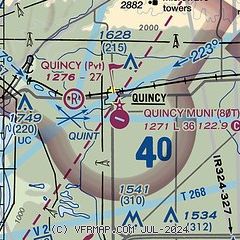
|
| Airport distance calculator |
|---|
|
|
| Sunrise and sunset |
|---|
|
Times for 24-Jan-2026
| | Local
(UTC-8) | | Zulu
(UTC) |
|---|
| Morning civil twilight | | 07:01 | | 15:01 |
| Sunrise | | 07:35 | | 15:35 |
| Sunset | | 16:48 | | 00:48 |
| Evening civil twilight | | 17:22 | | 01:22 |
|
| Current date and time |
|---|
| Zulu (UTC) | 24-Jan-2026 23:43:47 |
|---|
| Local (UTC-8) | 24-Jan-2026 15:43:47 |
|---|
|
| METAR |
|---|
KEPH
14nm E | 242253Z AUTO 15004KT 10SM CLR 01/M06 A3028 RMK AO2 SLP270 T00111061
|
KEAT
19nm NW | 242255Z AUTO 14003KT 10SM CLR 01/M07 A3028 RMK AO2 SLP268 T00111067
|
KMWH
21nm E | 242252Z 19005KT 10SM CLR 02/M07 A3030 RMK AO2 SLP276 T00171067
|
|
| TAF |
|---|
KEAT
19nm NW | 241730Z 2418/2518 28006KT P6SM SKC FM242000 VRB03KT P6SM SKC FM251200 29004KT P6SM SKC
|
KMWH
21nm E | 241730Z 2418/2518 VRB03KT P6SM SKC FM250600 02005KT P6SM SKC
|
|
| NOTAMs |
|---|
NOTAMs are issued by the DoD/FAA and will open in a separate window not controlled by AirNav.
|
|

