FAA INFORMATION EFFECTIVE 22 JANUARY 2026
Location
| FAA Identifier: | 89NY |
| Lat/Long: | 44-19-00.1820N 075-53-58.8240W
44-19.003033N 075-53.980400W
44.3167172,-75.8996733
(estimated) |
| Elevation: | 340 ft. / 104 m (estimated) |
| Variation: | 13W (1985) |
| From city: | 2 miles S of ALEXANDRIA BAY, NY |
| Time zone: | UTC -5 (UTC -4 during Daylight Saving Time) |
| Zip code: | 13607 |
Airport Operations
| Airport use: | Private use. Permission required prior to landing |
| Activation date: | 04/1966 |
| Control tower: | no |
| ARTCC: | BOSTON CENTER |
| FSS: | BURLINGTON FLIGHT SERVICE STATION |
| Attendance: | UNATNDD |
| Segmented circle: | no |
Airport Communications
Nearby radio navigation aids
| VOR radial/distance | | VOR name | | Freq | | Var |
|---|
| ARTr030/23.0 | | WATERTOWN VORTAC | | 109.80 | | 12W |
Airport Services
| Parking: | tiedowns |
| Airframe service: | MAJOR |
| Powerplant service: | MAJOR |
Runway Information
Runway 6/24
| Dimensions: | 4280 x 60 ft. / 1305 x 18 m |
| Surface: | asphalt, in fair condition
RWY 06, FIRST 200' OF PVMT POOR COND. |
| Runway edge markings: | MARKINGS WORN AND FADED. |
| RUNWAY 6 | | RUNWAY 24 |
| Traffic pattern: | left | | left |
| Markings: | basic, in good condition | | basic, in good condition |
| Visual slope indicator: | 2-light PAPI on left (3.00 degrees glide path) | | 2-light PAPI on left (3.00 degrees glide path) |
| Runway end identifier lights: | yes | | yes |
| Obstructions: | 37 ft. trees, 215 ft. from runway, 119 ft. right of centerline
RY 06 HAS + 23 FT, BRUSH & TREES, 10 FT - 71 FT FM THLD, 114 FT - 122 FT LEFT; +20 FT BRUSH, 94 FT FM THLD, 113 FT RIGHT. | | 18 ft. road, 200 ft. from runway
RY 24 HAS 34 FT PLINE 121 FT & 163 FT FM THLD 161 FT L & 132 FT R; +15' FT ROAD, 168 FT TO 199 FT FM THLD, BOTH SIDES. |
Airport Ownership and Management from official FAA records
| Ownership: | Privately-owned |
| Owner: | MAXSON AIRFIELD LLC
2706 POPPLETON RD
DURHAMVILLE, NY 13054
Phone 315-525-7632 |
| Manager: | NED DENIGAN
106 BELLEFAIR LN
WEST CHESTER, PA 19382
Phone 610-787-2653 |
Additional Remarks
| - | RWY 06/24, ACT MAG BRG = 05/23 |
| - | FOR CD CTC WHEELER SACK APCH AT 315-772-7105. |
| - | ACES BY MEMBERSHIIP ONLY. NO OTHER ACFT HAVE PMSN TO LAND. CALL AMGR TO INQUIRE ABOUT MEMBERSHIP. NON-MEMBERS WILL BE RPRTD FOR VIOLATIONS. |
Instrument Procedures
There are no published instrument procedures at 89NY.
Some nearby airports with instrument procedures:
KGTB - Wheeler-Sack Army Airfield (17 nm SE)
KART - Watertown International Airport (20 nm S)
KOGS - Ogdensburg International Airport (29 nm NE)
KPTD - Potsdam Municipal Airport/Damon Field (46 nm NE)
KMSS - Massena International Airport-Richards Field (58 nm NE)
|
|

Road maps at:
MapQuest
Bing
Google
| Aerial photo |
|---|
WARNING: Photo may not be current or correct
 Photo by Sam Andrews
Photo taken 28-Aug-2010
looking northwest.
Photo by Sam Andrews
Photo taken 28-Aug-2010
looking northwest.
Do you have a better or more recent aerial photo of Maxson Airfield that you would like to share? If so, please send us your photo.
|
| Sectional chart |
|---|
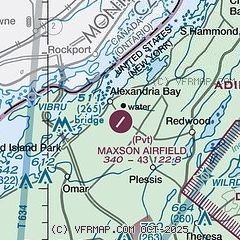
|
| Airport distance calculator |
|---|
|
|
| Sunrise and sunset |
|---|
|
Times for 30-Jan-2026
| | Local
(UTC-5) | | Zulu
(UTC) |
|---|
| Morning civil twilight | | 06:54 | | 11:54 |
| Sunrise | | 07:25 | | 12:25 |
| Sunset | | 17:09 | | 22:09 |
| Evening civil twilight | | 17:40 | | 22:40 |
|
| Current date and time |
|---|
| Zulu (UTC) | 30-Jan-2026 07:42:04 |
|---|
| Local (UTC-5) | 30-Jan-2026 02:42:04 |
|---|
|
| METAR |
|---|
CWGH
6nm N | 300700Z AUTO 26001KT M22/M26 RMK AO1 SLP229 T12241257 57006
|
KGTB
19nm SE | 300655Z 27006KT 10SM CLR M22/M26 A3012 RMK AO2A SLP223 T12231260 $
|
|
| TAF |
|---|
KGTB
19nm SE | 300100Z 3001/3107 34005KT 9999 SCT025 OVC050 610505 QNH3008INS TEMPO 3001/3003 31005KT 4800 BR SCT020 BKN030 610307 QNH3012INS BECMG 3010/3011 27005KT 9999 BKN025 OVC040 610208 QNH3013INS BECMG 3021/3022 27005KT 9999 SCT020 OVC030 610307 QNH3015INS TXM17/3021Z TNM23/3009Z
|
KART
21nm S | 300526Z 3006/3106 29005KT P6SM SCT250 FM301100 24006KT P6SM SCT120 FM301600 25006KT P6SM BKN060 FM302200 VRB03KT P6SM BKN040 FM310200 00000KT P6SM BKN040
|
|
| NOTAMs |
|---|
NOTAMs are issued by the DoD/FAA and will open in a separate window not controlled by AirNav.
|
|

