FAA INFORMATION EFFECTIVE 09 JULY 2026
Location
| FAA Identifier: | 8D1 |
| Lat/Long: | 43-56-38.7765N 088-06-53.4301W
43-56.646275N 088-06.890502W
43.9441046,-88.1148417
(estimated) |
| Elevation: | 992.2 ft. / 302.4 m (surveyed) |
| Variation: | 03W (2010) |
| From city: | 1 mile W of NEW HOLSTEIN, WI |
| Time zone: | UTC -5 (UTC -6 during Standard Time) |
| Zip code: | 53061 |
Airport Operations
| Airport use: | Open to the public |
| Activation date: | 09/1958 |
| Control tower: | no |
| ARTCC: | CHICAGO CENTER |
| FSS: | GREEN BAY FLIGHT SERVICE STATION |
| NOTAMs facility: | GRB (NOTAM-D service available) |
| Attendance: | UNATNDD |
| Wind indicator: | lighted |
| Segmented circle: | yes |
| Lights: | TO INCR INTST & ACTVT REIL RWY 14/32; PAPI RWY 14/32; MIRL RWY 14/32 PRESET TO LOW SS-SR - CTAF. |
| Beacon: | white-green (lighted land airport)
Operates sunset to sunrise. |
Airport Communications
| CTAF/UNICOM: | 123.0 |
| MILWAUKEE APPROACH: | 127.0 |
| MILWAUKEE DEPARTURE: | 127.0 |
| WX ASOS at SBM (15 nm SE): | 118.425 (920-467-0744) |
| WX ASOS at FLD (19 nm SW): | 134.0 (920-922-4444) |
| WX ASOS at OSH (19 nm W): | PHONE 920-426-1644 |
Nearby radio navigation aids
| VOR radial/distance | | VOR name | | Freq | | Var |
|---|
| OSHr096/19.2 | | OSHKOSH VOR/DME | | 116.75 | | 02E |
| BJBr002/(31.3) | | WEST BEND VOR | | 109.80 | | 01W |
| GRBr174/36.8 | | GREEN BAY VORTAC | | 115.50 | | 01E |
Airport Services
| Fuel available: | 100LL
100LL:24 HR SELF SVC FUEL WITH CREDIT CARD. |
| Parking: | hangars and tiedowns |
| Airframe service: | MAJOR |
| Powerplant service: | MAJOR |
Runway Information
Runway 14/32
| Dimensions: | 3600 x 75 ft. / 1097 x 23 m |
| Surface: | asphalt, in excellent condition |
| Weight bearing capacity: | |
| Runway edge lights: | medium intensity |
| RUNWAY 14 | | RUNWAY 32 |
| Latitude: | 43-56.885717N | | 43-56.423222N |
| Longitude: | 088-07.064270W | | 088-06.553188W |
| Elevation: | 976.6 ft. | | 976.5 ft. |
| Traffic pattern: | left | | left |
| Runway heading: | 144 magnetic, 141 true | | 324 magnetic, 321 true |
| Markings: | nonprecision, in fair condition | | nonprecision, in fair condition |
| Visual slope indicator: | 2-light PAPI on left (3.20 degrees glide path) | | 2-light PAPI on left (3.00 degrees glide path) |
| Runway end identifier lights: | yes | | yes |
| Touchdown point: | yes, no lights | | yes, no lights |
| Obstructions: | 65 ft. trees, 1240 ft. from runway, 385 ft. right of centerline, 16:1 slope to clear | | none |
Runway 4/22
| Dimensions: | 2951 x 250 ft. / 899 x 76 m |
| Surface: | turf, in fair condition |
| Runway edge markings: | MKD WITH ORANGE/WHITE A-FRAMES. |
| Operational restrictions: | NOT PLOWED, CFM CONDS WITH AMGR. |
| RUNWAY 4 | | RUNWAY 22 |
| Latitude: | 43-56.454092N | | 43-56.818463N |
| Longitude: | 088-07.212500W | | 088-06.768013W |
| Elevation: | 992.1 ft. | | 973.6 ft. |
| Traffic pattern: | left | | right |
| Runway heading: | 044 magnetic, 041 true | | 224 magnetic, 221 true |
| Markings: | none | | none |
| Runway end identifier lights: | no | | no |
| Touchdown point: | yes, no lights | | yes, no lights |
| Obstructions: | none | | 63 ft. trees, 935 ft. from runway, 200 ft. left of centerline, 14:1 slope to clear |
Airport Ownership and Management from official FAA records
| Ownership: | Publicly-owned |
| Owner: | CITY OF NEW HOLSTEIN
2110 WASHINGTON ST
NEW HOLSTEIN, WI 53061
Phone 920-898-5766 |
| Manager: | PERRY WELCH
2110 WASHINGTON ST
NEW HOLSTEIN, WI 53061
Phone 920-219-0015 |
Additional Remarks
| - | NUMEROUS BIRDS INVOF ARPT. |
| - | FOR CD CTC CHICAGO ARTCC AT 630-906-8921. |
| - | WINGSPAN RSTRNS ARE CURRENTLY IN EFCT ON TXLS C, D, AND E. |
Instrument Procedures
NOTE: All procedures below are presented as PDF files. If you need a reader for these files, you should download the free Adobe Reader.NOT FOR NAVIGATION. Please procure official charts for flight.
FAA instrument procedures published for use from 09 July 2026 at 0901Z to 06 August 2026 at 0900Z.
IAPs - Instrument Approach Procedures |
|---|
| RNAV (GPS) RWY 14 | |
download (233KB) |
| RNAV (GPS) RWY 32 | |
download (247KB) |
| NOTE: Special Take-Off Minimums/Departure Procedures apply | |
download (201KB) |
Other nearby airports with instrument procedures:
KSBM - Sheboygan County Memorial International Airport (15 nm SE)
KFLD - Fond Du Lac County Airport (19 nm SW)
KOSH - Wittman Regional Airport (19 nm W)
KMTW - Manitowoc County Airport (22 nm NE)
KATW - Appleton International Airport (26 nm NW)
|
|

Road maps at:
MapQuest
Bing
Google
| Aerial photo |
|---|
WARNING: Photo may not be current or correct

Do you have a better or more recent aerial photo of New Holstein Municipal Airport that you would like to share? If so, please send us your photo.
|
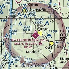
| Sectional chart |
|---|
|
| Airport distance calculator |
|---|
|
|
| Sunrise and sunset |
|---|
|
Times for 31-Jul-2026
| | Local
(UTC-5) | | Zulu
(UTC) |
|---|
| Morning civil twilight | | 05:08 | | 10:08 |
| Sunrise | | 05:41 | | 10:41 |
| Sunset | | 20:17 | | 01:17 |
| Evening civil twilight | | 20:50 | | 01:50 |
|
| Current date and time |
|---|
| Zulu (UTC) | 01-Aug-2026 01:53:33 |
|---|
| Local (UTC-5) | 31-Jul-2026 20:53:33 |
|---|
|
| METAR |
|---|
KSBM
15nm SE | 010053Z AUTO 04005KT 4SM BR SCT070 OVC110 20/19 A2991 RMK AO2 RAE14 SLP125 P0001 T02000189 $
|
KOSH
19nm W | 010130Z 28004KT 6SM -RA BR FEW016 SCT022 OVC095 18/18 A2992 RMK AO2 P0014 T01830178
|
KFLD
19nm SW | 010053Z AUTO 00000KT 10SM -RA FEW042 FEW060 OVC090 18/18 A2992 RMK AO2 SLP131 P0011 T01830178
|
KMTW
22nm NE | 010056Z AUTO 04004KT 10SM -RA BKN047 BKN060 OVC070 21/21 A2993 RMK AO2 SLP130 P0000 T02060206 $
|
KATW
25nm NW | 010045Z 00000KT 7SM -RA BKN034 22/20 A2994
|
|
| TAF |
|---|
KSBM
15nm SE | 312112Z 3121/0118 15004KT P6SM BKN110 FM312200 15009KT 2SM RA BR BKN015 FM010400 07010G18KT 6SM -SHRA BKN017 OVC030 FM011400 05013G23KT P6SM SCT016 BKN022 PROB30 0116/0118 4SM -SHRA OVC015
|
|
| NOTAMs |
|---|
NOTAMs are issued by the DoD/FAA and will open in a separate window not controlled by AirNav.
|
|

