FAA INFORMATION EFFECTIVE 14 MAY 2026
Location
| FAA Identifier: | 8W2 |
| Lat/Long: | 38-39-21.5450N 078-42-30.5850W
38-39.359083N 078-42.509750W
38.6559847,-78.7084958
(estimated) |
| Elevation: | 962.7 ft. / 293 m (estimated) |
| Variation: | 10W (2010) |
| From city: | 2 miles W of NEW MARKET, VA |
| Time zone: | UTC -4 (UTC -5 during Standard Time) |
| Zip code: | 22853 |
Airport Operations
| Airport use: | Open to the public |
| Control tower: | no |
| ARTCC: | WASHINGTON CENTER |
| FSS: | LEESBURG FLIGHT SERVICE STATION |
| NOTAMs facility: | DCA (NOTAM-D service available) |
| Attendance: | M-F 0800 - 1630
UNATNDD THANKSGIVING, CHRISTMAS, AND NEW YEAR'S DAY. |
| Pattern altitude: | 1787.7 ft. MSL |
| Wind indicator: | lighted |
| Segmented circle: | no |
| Lights: | SS-SR |
| Beacon: | white-green (lighted land airport)
Operates sunset to sunrise. |
Airport Communications
| CTAF/UNICOM: | 122.8 |
| WX AWOS-3: | 118.175 (540-740-3801) |
| WX AWOS-3 at LUA (10 nm E): | 118.275 (540-743-1148) |
- APCH/DEP SVC PRVDD BY WASHINGTON ARTCC ON FREQS 133.2/282.2 (BUCKS ELBOW RCAG).
Nearby radio navigation aids
| VOR radial/distance | | VOR name | | Freq | | Var |
|---|
| LDNr249/26.4 | | LINDEN VORTAC | | 114.30 | | 06W |
| ESLr165/36.6 | | KESSEL VOR/DME | | 110.80 | | 06W |
| CSNr277/39.5 | | CASANOVA VORTAC | | 116.30 | | 06W |
| NDB name | | Hdg/Dist | | Freq | | Var | | ID |
|---|
| CAVERNS | | 266/11.4 | | 245 | | 09W | | LUA | .-.. ..- .- |
| NAILR | | 298/39.6 | | 351 | | 10W | | MSQ | -- ... --.- |
Airport Services
| Fuel available: | 100LL
100LL:24 HR CREDIT CARD SVC |
| Parking: | hangars and tiedowns |
| Airframe service: | MAJOR
BLN RPR STN; ACFT RPRS AVBL, BUT NOT FULL-TIME. |
| Powerplant service: | MAJOR
PWR PLANT RPRS AVBL, BUT NOT FULL-TIME. |
| Bottled oxygen: | NONE |
| Bulk oxygen: | NONE |
Runway Information
Runway 6/24
| Dimensions: | 2920 x 60 ft. / 890 x 18 m |
| Surface: | asphalt, in excellent condition |
| Runway edge lights: | non-standard
NSTD LIRL; THLD LGTS ONE FIXTURE EACH SIDE. RY 06 LGTD THLD RELOCATED 100 FT & RY 24 LGTD THLD RELOCATED 930 FT FOR NGT OPNS; 2020 FT RY 06/24 LGTD AT NGT. NO RY END LGTS RY 24. |
| RUNWAY 6 | | RUNWAY 24 |
| Latitude: | 38-39.213900N | | 38-39.504333N |
| Longitude: | 078-42.754283W | | 078-42.265183W |
| Elevation: | 962.2 ft. | | 962.3 ft. |
| Traffic pattern: | right | | left |
| Runway heading: | 063 magnetic, 053 true | | 243 magnetic, 233 true |
| Displaced threshold: | no | | 918 ft. |
| Markings: | basic, in good condition | | basic, in good condition |
| Touchdown point: | yes, no lights | | yes, no lights |
| Obstructions: | none
RIDGE & TREES PERPINDICULAR TO RWY 06; 225 FT LEFT OF CNTRLN & APRXLY 1300 FT FROM THLD. | | 15 ft. road, 201 ft. from runway, 100 ft. left of centerline
RY 24, 5 FT FENCE 110 FT FM THLD 0B, 15 FT ROAD 115 FT FM THLD 0B, POLE 90 FT FM THR 100 FT R, 23 FT PLINE 114 FT FM THLD 117 FT L. |
Airport Ownership and Management from official FAA records
| Ownership: | Privately-owned |
| Owner: | ROBERT THOMAS
PO BOX 762
MIDDLEBURG, VA 20118
Phone (703) 898-1157 |
| Manager: | ROBERT THOMAS
PO BOX 762
MIDDLEBURG, VA 20118
Phone 703-327-0444 |
Additional Remarks
| - | DEER AND BIRDS ON & INVOF RY. |
| - | FOR CD CTC WASHINGTON ARTCC AT 703-771-3587. |
| - | HOT AIR BALLOONS WEEKENDS EARLY MORNING & LATE AFTERNOON. |
| - | APRXLY 1000 FT N OF RY, 200 FT RIDGE/TREES PARALLEL RY. |
| - | ARRIVING PILOTS SHOULD USE CAUTION. SKYDIVING OPERATIONS WITHIN 2NM OF THE AIRPORT FROM 0800-SUNSET EVERY WEEKEND AND OCCASIONALLY DURING THE WEEK. |
Instrument Procedures
NOTE: All procedures below are presented as PDF files. If you need a reader for these files, you should download the free Adobe Reader.NOT FOR NAVIGATION. Please procure official charts for flight.
FAA instrument procedures published for use from 14 May 2026 at 0901Z to 11 June 2026 at 0900Z.
IAPs - Instrument Approach Procedures |
|---|
| RNAV (GPS)-A | |
download (186KB) |
| RNAV (GPS)-B | |
download (178KB) |
| NOTE: Special Alternate Minimums apply | |
download |
| NOTE: Special Take-Off Minimums/Departure Procedures apply | |
download (140KB) |
Other nearby airports with instrument procedures:
KLUA - Luray Caverns Airport (10 nm E)
KVBW - Bridgewater Air Park (21 nm SW)
KSHD - Shenandoah Valley Regional Airport (25 nm S)
KFRR - Front Royal-Warren County Airport (26 nm NE)
W99 - Grant County Airport (29 nm NW)
|
|

Road maps at:
MapQuest
Bing
Google
| Aerial photo |
|---|
WARNING: Photo may not be current or correct

Do you have a better or more recent aerial photo of New Market Airport that you would like to share? If so, please send us your photo.
|
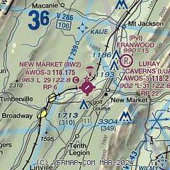
| Sectional chart |
|---|
|
| Airport distance calculator |
|---|
|
|
| Sunrise and sunset |
|---|
|
Times for 31-May-2026
| | Local
(UTC-4) | | Zulu
(UTC) |
|---|
| Morning civil twilight | | 05:22 | | 09:22 |
| Sunrise | | 05:53 | | 09:53 |
| Sunset | | 20:32 | | 00:32 |
| Evening civil twilight | | 21:03 | | 01:03 |
|
| Current date and time |
|---|
| Zulu (UTC) | 31-May-2026 13:45:46 |
|---|
| Local (UTC-4) | 31-May-2026 09:45:46 |
|---|
|
| METAR |
|---|
| K8W2 | 311335Z AUTO 00000KT 10SM CLR 16/05 A3017 RMK AO1 T01620048
|
KLUA
10nm E | 311335Z AUTO 00000KT 10SM CLR 20/06 A3017 RMK AO2
|
|
| TAF |
|---|
KCHO
34nm S | 311124Z 3112/0112 VRB03KT P6SM FEW250 FM312100 17004KT P6SM FEW150 FM010500 33003KT P6SM FEW150
|
|
| NOTAMs |
|---|
NOTAMs are issued by the DoD/FAA and will open in a separate window not controlled by AirNav.
|
|

