FAA INFORMATION EFFECTIVE 14 MAY 2026
Location
| FAA Identifier: | CHO |
| Lat/Long: | 38-08-22.7140N 078-27-08.4390W
38-08.378567N 078-27.140650W
38.1396428,-78.4523442
(estimated) |
| Elevation: | 640.1 ft. / 195.1 m (surveyed) |
| Variation: | 08W (1985) |
| From city: | 7 miles N of CHARLOTTESVILLE, VA |
| Time zone: | UTC -4 (UTC -5 during Standard Time) |
| Zip code: | 22936 |
Airport Operations
| Airport use: | Open to the public |
| Control tower: | yes |
| ARTCC: | WASHINGTON CENTER |
| FSS: | LEESBURG FLIGHT SERVICE STATION |
| NOTAMs facility: | CHO (NOTAM-D service available) |
| Attendance: | CONTINUOUS |
| Wind indicator: | lighted |
| Segmented circle: | yes |
| Lights: | WHEN ATCT CLSD HIRL RWY 03/21, & TWY LIGHTS PRESET LOW INTST. TO ACTVT & INCREASE INTST MALSR RWY 03; REIL RWY 21; HIRL RWY 03/21 & TWY LIGHTS - CTAF. |
| Beacon: | white-green (lighted land airport)
Operates sunset to sunrise. |
| Landing fee: | yes, LNDG FEE ONLY FOR ACFT OVER 7000 LBS. |
| Fire and rescue: | ARFF index B |
| Airline operations: | PPR 24 HRS FOR UNSKED AIR CARRIER OPS WITH MORE THAN 30 PSGR SEATS, 24 HR PPR FOR ALL FIXED WING MIL AIRCRAFT RON, CALL AMGR AT 434-981-4152. |
Airport Communications
| CTAF: | 124.5 |
| UNICOM: | 122.95 |
| ATIS: | 118.425 |
| WX ASOS: | PHONE 434-975-0110 |
| CHARLOTTESVILLE GROUND: | 121.9 338.275 [0600-2300] |
| CHARLOTTESVILLE TOWER: | 124.5 338.275 [0600-2300] |
| POTOMAC APPROACH: | 132.85 120.525 |
| POTOMAC DEPARTURE: | 132.85 120.525 |
| EMERG: | 121.5 243.0 |
| WX AWOS-3 at GVE (14 nm E): | 120.225 (540-832-2095) |
Nearby radio navigation aids
| VOR radial/distance | | VOR name | | Freq | | Var |
|---|
| GVEr304/16.0 | | GORDONSVILLE VORTAC | | 115.60 | | 06W |
| MOLr070/34.1 | | MONTEBELLO VOR/DME | | 115.30 | | 05W |
| NDB name | | Hdg/Dist | | Freq | | Var | | ID |
|---|
| NAILR | | 244/31.9 | | 351 | | 10W | | MSQ | -- ... --.- |
| CAVERNS | | 187/33.6 | | 245 | | 09W | | LUA | .-.. ..- .- |
Airport Services
| Fuel available: | 100LL JET-A |
| Parking: | hangars and tiedowns |
| Airframe service: | MAJOR |
| Powerplant service: | MAJOR |
| Bottled oxygen: | NONE |
| Bulk oxygen: | NONE |
Runway Information
Runway 3/21
| Dimensions: | 6801 x 150 ft. / 2073 x 46 m |
| Surface: | asphalt/grooved, in good condition |
| Weight bearing capacity: | | Single wheel: | 89.0 | | Double wheel: | 114.0 | | Double tandem: | 171.0 |
|
| Runway edge lights: | high intensity |
| RUNWAY 3 | | RUNWAY 21 |
| Latitude: | 38-07.859615N | | 38-08.897513N |
| Longitude: | 078-27.407948W | | 078-26.873303W |
| Elevation: | 640.1 ft. | | 618.3 ft. |
| Traffic pattern: | left | | left |
| Runway heading: | 030 magnetic, 022 true | | 210 magnetic, 202 true |
| Declared distances: | TORA:6801 TODA:6801 ASDA:6801 LDA:6801 | | TORA:6801 TODA:6801 ASDA:6801 LDA:6801 |
| Markings: | precision, in good condition | | nonprecision, in good condition |
| Visual slope indicator: | 4-light PAPI on left (3.00 degrees glide path) | | 4-light PAPI on right (3.00 degrees glide path)
UNUSBL BYD 6.5 DEG L OF RCL. |
| Approach lights: | MALSR: 1,400 foot medium intensity approach lighting system with runway alignment indicator lights | | |
| Runway end identifier lights: | | | yes |
| Touchdown point: | yes, no lights | | yes, no lights |
| Instrument approach: | ILS/DME | | |
Airport Ownership and Management from official FAA records
| Ownership: | Publicly-owned |
| Owner: | CHRLTSVL-ALBMRL ARPT AUTH
100 BOWEN LOOP, SUITE 200
CHARLOTTESVILLE, VA 22911
Phone 434-973-8341 |
| Manager: | JASON BURCH
100 BOWEN LOOP, SUITE 200
CHARLOTTESVILLE, VA 22911
Phone 434-973-8342
X104. |
Additional Remarks
| A39-03/21 | PCR VALUE: 360/F/D/X/T |
| - | DEER & BIRDS ON & INVOF ARPT. |
| - | FOR CD WHEN ATCT IS CLSD CTC POTOMAC APCH AT 866-640-4124. |
| - | FOR ACFT SVCS CTC 126.925. |
| A58-21 | +7 FT OBST LGTD EQPT BOX RACK 78 FT FM AER, 250 FT L. |
Instrument Procedures
NOTE: All procedures below are presented as PDF files. If you need a reader for these files, you should download the free Adobe Reader.NOT FOR NAVIGATION. Please procure official charts for flight.
FAA instrument procedures published for use from 14 May 2026 at 0901Z to 11 June 2026 at 0900Z.
IAPs - Instrument Approach Procedures |
|---|
| ILS OR LOC RWY 03 | |
download (349KB) |
| RNAV (GPS) RWY 03 | |
download (306KB) |
| RNAV (GPS) Y RWY 21 | |
download (244KB) |
| RNAV (GPS) Z RWY 21 | |
download (238KB) |
| NOTE: Special Alternate Minimums apply | |
download (168KB) |
| NOTE: Special Take-Off Minimums/Departure Procedures apply | |
download (358KB) |
Other nearby airports with instrument procedures:
KGVE - Gordonsville Municipal Airport (14 nm E)
KOMH - Orange County Airport (20 nm E)
KSHD - Shenandoah Valley Regional Airport (22 nm W)
W13 - Eagle's Nest Airport (24 nm W)
KLKU - Louisa County Airport/Freeman Field (24 nm E)
|
|

Road maps at:
MapQuest
Bing
Google
| Aerial photo |
|---|
WARNING: Photo may not be current or correct
 Photo by Glenn Woodell, of NASA Langley Research Center
Photo taken 10-Apr-2014
looking south.
Photo by Glenn Woodell, of NASA Langley Research Center
Photo taken 10-Apr-2014
looking south.
Do you have a better or more recent aerial photo of Charlottesville-Albemarle Airport that you would like to share? If so, please send us your photo.
|
| Sectional chart |
|---|
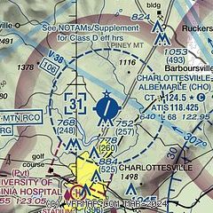
|
 Download PDF
of official airport diagram from the FAA
| Airport distance calculator |
|---|
|
|
| Sunrise and sunset |
|---|
|
Times for 31-May-2026
| | Local
(UTC-4) | | Zulu
(UTC) |
|---|
| Morning civil twilight | | 05:23 | | 09:23 |
| Sunrise | | 05:54 | | 09:54 |
| Sunset | | 20:29 | | 00:29 |
| Evening civil twilight | | 21:00 | | 01:00 |
|
| Current date and time |
|---|
| Zulu (UTC) | 31-May-2026 20:47:47 |
|---|
| Local (UTC-4) | 31-May-2026 16:47:47 |
|---|
|
| METAR |
|---|
| KCHO | 311953Z 08003KT 10SM CLR 24/09 A3000 RMK AO2 SLP155 T02390089
|
KGVE
14nm E | 312035Z AUTO 16004KT 10SM CLR 25/10 A2998 RMK AO1 T02500102
|
|
| TAF |
|---|
| KCHO | 311732Z 3118/0118 19005KT P6SM FEW050 FEW250 FM010900 33003KT P6SM FEW050 BKN250 FM011400 03008KT P6SM FEW050 BKN250
|
|
| NOTAMs |
|---|
NOTAMs are issued by the DoD/FAA and will open in a separate window not controlled by AirNav.
|
|


