FAA INFORMATION EFFECTIVE 16 APRIL 2026
Location
| FAA Identifier: | W13 |
| Lat/Long: | 38-04-36.9750N 078-56-39.9750W
38-04.616250N 078-56.666250W
38.0769375,-78.9444375
(estimated) |
| Elevation: | 1436 ft. / 438 m (estimated) |
| Variation: | 09W (2010) |
| From city: | 3 miles W of WAYNESBORO, VA |
| Time zone: | UTC -4 (UTC -5 during Standard Time) |
| Zip code: | 22980 |
Airport Operations
| Airport use: | Open to the public |
| Activation date: | 12/1946 |
| Control tower: | no |
| ARTCC: | WASHINGTON CENTER |
| FSS: | LEESBURG FLIGHT SERVICE STATION |
| NOTAMs facility: | DCA (NOTAM-D service available) |
| Attendance: | MON - FRI 0800 - 1700, ALL SUN 1000 - 1600, ALL SAT 0900 - 1600 |
| Wind indicator: | yes |
| Segmented circle: | no |
| Lights: | ACTVT MIRL RWY 06/24 - CTAF. |
| Beacon: | white-green (lighted land airport)
Operates sunset to sunrise. |
Airport Communications
| CTAF/UNICOM: | 123.05 |
| WX AWOS-3PT: | 118.625 (540-941-7570) |
| POTOMAC APPROACH: | 132.85 |
| POTOMAC DEPARTURE: | 132.85 |
| WX AWOS-3 at SHD (11 nm N): | 124.925 (540-234-0110) |
| WX AWOS-3 at VBW (17 nm N): | 119.55 (540-828-2076) |
Nearby radio navigation aids
| VOR radial/distance | | VOR name | | Freq | | Var |
|---|
| MOLr041/13.1 | | MONTEBELLO VOR/DME | | 115.30 | | 05W |
| GVEr282/37.6 | | GORDONSVILLE VORTAC | | 115.60 | | 06W |
| NDB name | | Hdg/Dist | | Freq | | Var | | ID |
|---|
| STAUT | | 184/7.5 | | 375 | | 09W | | SH | ... .... |
Airport Services
| Fuel available: | 100LL |
| Parking: | hangars and tiedowns |
| Airframe service: | MAJOR |
| Powerplant service: | MAJOR |
| Bottled oxygen: | NONE |
| Bulk oxygen: | NONE |
Runway Information
Runway 6/24
| Dimensions: | 2004 x 50 ft. / 611 x 15 m |
| Surface: | asphalt, in good condition |
| Runway edge lights: | medium intensity |
| RUNWAY 6 | | RUNWAY 24 |
| Latitude: | 38-04.515333N | | 38-04.717167N |
| Longitude: | 078-56.831500W | | 078-56.501000W |
| Elevation: | 1436.0 ft. | | 1430.0 ft. |
| Traffic pattern: | left | | left |
| Markings: | numbers only, in good condition | | numbers only, in good condition |
| Touchdown point: | yes, no lights | | yes, no lights |
| Obstructions: | 48 ft. tree, 490 ft. from runway, 117 ft. left of centerline, 6:1 slope to clear
8 FT BRUSH AND TREES LEFT SIDE OF RWY APRXLY 155 FM THR AND 108 FT FM CNTRLN. | | 28 ft. tree, 535 ft. from runway, 136 ft. left of centerline, 11:1 slope to clear |
Airport Ownership and Management from official FAA records
| Ownership: | Privately-owned |
| Owner: | MICHAEL L FOGLE
P. O. BOX 691236
CHARLOTTE, NC 28227-7021
Phone 704-576-3500 |
| Manager: | MICHAEL T.K. ROSOLINA
249 AERO DR
WAYNESBORO, VA 22980
Phone 540-943-4447 |
Additional Remarks
| - | DEER ON AND INVOF ARPT. |
| - | NO REPETITIVE PRACTICE TKOFS AND LDGS AFT 0100Z. |
| - | NO GRASS LANDINGS OR TAKEOFFS EITHER SIDE OF RWY 06/24. |
| - | FOR CD CTC POTOMAC APCH AT 866-640-4124. |
Instrument Procedures
NOTE: All procedures below are presented as PDF files. If you need a reader for these files, you should download the free Adobe Reader.NOT FOR NAVIGATION. Please procure official charts for flight.
FAA instrument procedures published for use from 16 April 2026 at 0901Z to 14 May 2026 at 0900Z.
IAPs - Instrument Approach Procedures |
|---|
| RNAV (GPS) RWY 06 | |
download (170KB) |
| RNAV (GPS) RWY 24 | |
download (162KB) |
| NOTE: Special Take-Off Minimums/Departure Procedures apply | |
download (140KB) |
Other nearby airports with instrument procedures:
KSHD - Shenandoah Valley Regional Airport (11 nm N)
KVBW - Bridgewater Air Park (17 nm N)
KCHO - Charlottesville-Albemarle Airport (24 nm E)
8W2 - New Market Airport (36 nm N)
KGVE - Gordonsville Municipal Airport (37 nm E)
|
|

Road maps at:
MapQuest
Bing
Google
| Aerial photo |
|---|
WARNING: Photo may not be current or correct

Do you have a better or more recent aerial photo of Eagle's Nest Airport that you would like to share? If so, please send us your photo.
|
| Sectional chart |
|---|
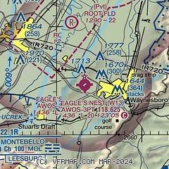
|
| Airport distance calculator |
|---|
|
|
| Sunrise and sunset |
|---|
|
Times for 10-May-2026
| | Local
(UTC-4) | | Zulu
(UTC) |
|---|
| Morning civil twilight | | 05:42 | | 09:42 |
| Sunrise | | 06:11 | | 10:11 |
| Sunset | | 20:14 | | 00:14 |
| Evening civil twilight | | 20:43 | | 00:43 |
|
| Current date and time |
|---|
| Zulu (UTC) | 10-May-2026 11:33:34 |
|---|
| Local (UTC-4) | 10-May-2026 07:33:34 |
|---|
|
| METAR |
|---|
| KW13 | 101115Z AUTO 24003KT 10SM CLR 12/07 A2995 RMK AO1 T01210071
|
KSHD
12nm N | 101115Z AUTO 00000KT 10SM CLR 09/07 A2997 RMK AO2 T00850070
|
KVBW
17nm N | 101115Z AUTO 00000KT 10SM CLR 07/07 A2995 RMK AO1 T00680068
|
|
| TAF |
|---|
KCHO
24nm E | 100544Z 1006/1106 00000KT P6SM SKC FM101400 24005KT P6SM FEW250 FM102000 32006KT P6SM BKN050 OVC090 PROB30 1021/1024 5SM -TSRA OVC040CB FM110100 03005KT P6SM BKN080
|
|
| NOTAMs |
|---|
NOTAMs are issued by the DoD/FAA and will open in a separate window not controlled by AirNav.
|
|

