FAA INFORMATION EFFECTIVE 14 MAY 2026
Location
| FAA Identifier: | ANK |
| Lat/Long: | 38-32-17.8000N 106-02-55.1000W
38-32.296667N 106-02.918333W
38.5382778,-106.0486389
(estimated) |
| Elevation: | 7523 ft. / 2293.0 m (surveyed) |
| Variation: | 09E (2010) |
| From city: | 2 miles W of SALIDA, CO |
| Time zone: | UTC -6 (UTC -7 during Standard Time) |
| Zip code: | 81201 |
Airport Operations
| Airport use: | Open to the public |
| Activation date: | 02/1964 |
| Control tower: | no |
| ARTCC: | DENVER CENTER |
| FSS: | DENVER FLIGHT SERVICE STATION |
| NOTAMs facility: | DEN (NOTAM-D service available) |
| Attendance: | WED-SUN 0800-1700 |
| Wind indicator: | lighted |
| Segmented circle: | yes |
| Lights: | ACTVT PAPI RWY 06 & 24; MIRL RWY 06/24 - CTAF. |
| Beacon: | white-green (lighted land airport)
Operates sunset to sunrise. |
Airport Communications
| CTAF/UNICOM: | 122.7 |
| WX AWOS-3PT: | 133.85 (719-539-5268) |
| WX AWOS-3 at AEJ (17 nm N): | 132.925 (719-395-2599) |
- APCH CTL SVC PRVDD BY DENVER ARTCC (ZDV) ON FREQS 128.375/379.95 (PUEBLO RCAG).
- DEP CTL SVC PRVDD BY DENVER ARTCC (ZDV) ON FREQS 119.85/363.15 (DENVER/B/ RCAG).
Airport Services
| Fuel available: | 100LL JET-A+
100LL:FUEL AVBL WITH CREDIT CARD. |
| Parking: | tiedowns |
| Bottled oxygen: | NONE |
Runway Information
Runway 6/24
| Dimensions: | 7351 x 75 ft. / 2241 x 23 m |
| Surface: | asphalt, in good condition |
| Weight bearing capacity: | | PCN 19 /F/A/X/T | | Single wheel: | 30.0 | | Double wheel: | 60.0 |
|
| Runway edge lights: | medium intensity |
| RUNWAY 6 | | RUNWAY 24 |
| Latitude: | 38-32.096618N | | 38-32.497645N |
| Longitude: | 106-03.644348W | | 106-02.190287W |
| Elevation: | 7523.0 ft. | | 7384.7 ft. |
| Traffic pattern: | left | | left |
| Runway heading: | 062 magnetic, 071 true | | 242 magnetic, 251 true |
| Markings: | basic, in good condition | | basic, in good condition |
| Visual slope indicator: | 2-light PAPI on left (3.50 degrees glide path) | | 2-light PAPI on left (3.00 degrees glide path)
PAPI DOES NOT PROVIDE OBSTACLE CLEARANCE BYD 2 NM FROM THRESHOLD, UNUSABLE BYD 2 NM. |
| Touchdown point: | yes, no lights | | yes, no lights |
| Obstructions: | 32 ft. road, 850 ft. from runway, 24 ft. right of centerline, 20:1 slope to clear | | none |
Helipad H1
| Dimensions: | 36 x 36 ft. / 11 x 11 m |
| Surface: | concrete, in good condition |
| Latitude: | 38-32.204167N | | |
| Longitude: | 106-02.949167W | | |
| Elevation: | 7458.0 ft. | | |
| Traffic pattern: | left | | left |
| Markings: | basic, in fair condition | | |
Airport Ownership and Management from official FAA records
| Ownership: | Publicly-owned |
| Owner: | CITY OF SALIDA/CHAFFEE COUNTY
COUNTY COURTHOUSE
SALIDA, CO 81201
Phone 719-539-2218
COUNTY CONTACT: ROBERT CHRISTIANSEN |
| Manager: | ZECHARIAH PAPP
9255 COUNTY ROAD 140
SALIDA, CO 81201
Phone (719) 239-1648 |
Additional Remarks
| - | BE ALERT; INTENSIVE USAF STUDENT TRAINING IN VICINITY OF COLORADO SPRINGS & PUEBLO COLORADO. |
| - | FOR CD CTC DENVER ARTCC AT 303-651-4257. |
| - | RY 24 HAS 365 FT UNLIGHTED SMOKESTACK 5082 FT FM THLD 2500 FT R OF CNTRLN. |
| - | DURING HIGH WIND CONDITIONS DOWNDRAFTS APPROACHING RY 24. |
| - | RY 24 RECOMMENDED FOR LANDING; RY 06 FOR DEPARTURE WEATHER & TRAFFIC PERMITTING. |
| - | RY 06 +60 FT POWERLINE MARKED WITH ORANGE BALLS 630 FT FM THLD, 435 FT LEFT OF RY EXTDD CNTRLN. |
Instrument Procedures
NOTE: All procedures below are presented as PDF files. If you need a reader for these files, you should download the free Adobe Reader.NOT FOR NAVIGATION. Please procure official charts for flight.
FAA instrument procedures published for use from 14 May 2026 at 0901Z to 11 June 2026 at 0900Z.
IAPs - Instrument Approach Procedures |
|---|
| RNAV (GPS)-A | |
download (339KB) |
| NOTE: Special Alternate Minimums apply | |
download (140KB) |
Departure Procedures |
|---|
| RONBE TWO (RNAV) | |
download (135KB) |
| NOTE: Special Take-Off Minimums/Departure Procedures apply | |
download (288KB) |
Other nearby airports with instrument procedures:
KAEJ - Central Colorado Regional Airport (17 nm N)
KGUC - Gunnison-Crested Butte Regional Airport (41 nm W)
KLXV - Lake County Airport (43 nm N)
1V6 - Fremont County Airport (45 nm E)
KRCV - Astronaut Kent Rominger Airport (52 nm S)
|
|

Road maps at:
MapQuest
Bing
Google
| Aerial photo |
|---|
WARNING: Photo may not be current or correct
 Photo by Lou Nieves, Jr.
Taken late April 2019
from 9,500 MSL looking north.
Photo by Lou Nieves, Jr.
Taken late April 2019
from 9,500 MSL looking north.
Do you have a better or more recent aerial photo of Salida Airport/Harriett Alexander Field that you would like to share? If so, please send us your photo.
|
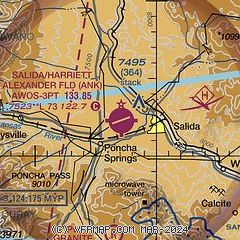
| Sectional chart |
|---|
|
| Airport distance calculator |
|---|
|
|
| Sunrise and sunset |
|---|
|
Times for 10-Jun-2026
| | Local
(UTC-6) | | Zulu
(UTC) |
|---|
| Morning civil twilight | | 05:09 | | 11:09 |
| Sunrise | | 05:40 | | 11:40 |
| Sunset | | 20:27 | | 02:27 |
| Evening civil twilight | | 20:58 | | 02:58 |
|
| Current date and time |
|---|
| Zulu (UTC) | 10-Jun-2026 14:03:55 |
|---|
| Local (UTC-6) | 10-Jun-2026 08:03:55 |
|---|
|
| METAR |
|---|
| KANK | 101355Z AUTO 25009G19KT 10SM CLR 20/M04 A3005 RMK AO2 T01981044 $
|
KMYP
13nm W | 101355Z AUTO 30034G41KT 10SM CLR 05/M06 A3043 RMK AO2
|
KAEJ
17nm N | 101355Z AUTO 07004KT 10SM CLR 18/M06 A3008 RMK AO2 T01761058
|
K7BM
18nm NW | 101355Z AUTO 26019G31KT 230V310 10SM CLR 13/M05 A3018 RMK AO2
|
|
| TAF |
|---|
KGUC
41nm W | 101126Z 1012/1112 14005KT P6SM SKC FM101500 25013G27KT P6SM SKC FM101800 26019G35KT P6SM SKC FM110200 27010G27KT P6SM FEW130 FEW250 FM110600 26009KT P6SM FEW150 FEW250
|
|
| NOTAMs |
|---|
NOTAMs are issued by the DoD/FAA and will open in a separate window not controlled by AirNav.
|
|

