FAA INFORMATION EFFECTIVE 09 JULY 2026
Location
| FAA Identifier: | C65 |
| Lat/Long: | 41-21-54.4700N 086-18-00.9280W
41-21.907833N 086-18.015467W
41.3651306,-86.3002578
(estimated) |
| Elevation: | 799.9 ft. / 243.8 m (surveyed) |
| Variation: | 05W (2020) |
| From city: | 2 miles N of PLYMOUTH, IN |
| Time zone: | UTC -4 (UTC -5 during Standard Time) |
| Zip code: | 46563 |
Airport Operations
| Airport use: | Open to the public |
| Activation date: | 12/1966 |
| Control tower: | no |
| ARTCC: | CHICAGO CENTER |
| FSS: | TERRE HAUTE FLIGHT SERVICE STATION |
| NOTAMs facility: | HUF (NOTAM-D service available) |
| Attendance: | MON-FRI 0800-1700, ALL SAT-SUN BY APPT |
| Wind indicator: | lighted |
| Segmented circle: | yes |
| Lights: | ACTVT REIL RWY 10 & 28; PAPI RWY 10; VASI RWY 28; MIRL RWY 10/28 - CTAF. |
| Beacon: | white-green (lighted land airport)
Operates sunset to sunrise. |
Airport Communications
| CTAF/UNICOM: | 122.975 |
| WX AWOS-3: | 133.025 (574-935-3854) |
| SOUTH BEND APPROACH: | 132.05 [1230-0400Z++] |
| SOUTH BEND DEPARTURE: | 132.05 [1230-0400Z++] |
| WX AWOS-3P at OXI (17 nm W): | 135.775 (574-772-2041) |
| WX AWOS-3 at RCR (19 nm S): | 118.775 (574-223-3560) |
- APCH/DEP SVC PRVDD BY CHICAGO ARTCC ON FREQS 135.9/314.0 (GOSHEN RCAG) WHEN SOUTH BEND APCH CTL CLSD.
Nearby radio navigation aids
| VOR radial/distance | | VOR name | | Freq | | Var |
|---|
| GIJr178/24.2 | | GIPPER VORTAC | | 115.40 | | 00E |
| OLKr284/(36.9) | | WEBSTER LAKE VOR | | 110.40 | | 03W |
Airport Services
| Fuel available: | 100LL JET-A
100LL:SELF SERVE AVBL H24. |
| Parking: | hangars and tiedowns |
| Airframe service: | MAJOR |
| Powerplant service: | MAJOR |
Runway Information
Runway 10/28
| Dimensions: | 4400 x 75 ft. / 1341 x 23 m |
| Surface: | asphalt, in good condition |
| Weight bearing capacity: | | Single wheel: | 25.0 | | Double wheel: | 40.0 |
|
| Runway edge lights: | medium intensity |
| RUNWAY 10 | | RUNWAY 28 |
| Latitude: | 41-21.944167N | | 41-21.871470N |
| Longitude: | 086-18.493885W | | 086-17.537047W |
| Elevation: | 795.9 ft. | | 799.9 ft. |
| Traffic pattern: | left | | left |
| Runway heading: | 101 magnetic, 096 true | | 281 magnetic, 276 true |
| Displaced threshold: | no | | 297 ft. |
| Markings: | nonprecision, in good condition | | nonprecision, in good condition |
| Visual slope indicator: | 2-light PAPI on left (3.00 degrees glide path) | | 4-box VASI on left (3.30 degrees glide path) |
| Runway end identifier lights: | yes | | yes |
| Touchdown point: | yes, no lights | | yes, no lights |
| Obstructions: | 85 ft. tree, 2000 ft. from runway, 183 ft. both sides of centerline, 21:1 slope to clear | | 15 ft. road, 490 ft. from runway, 300 ft. both sides of centerline, 19:1 slope to clear
APCH RATIO 34:1 AT DSPLCD THR. |
Airport Ownership and Management from official FAA records
| Ownership: | Publicly-owned |
| Owner: | PLYMOUTH BOAC
301 AIRPORT DRIVE
PLYMOUTH, IN 46563
Phone 574-935-5152
PHIL BOCKMAN |
| Manager: | BILL SHELEY
301 AIRPORT DRIVE
PLYMOUTH, IN 46563
Phone (574) 320-5059 |
Additional Remarks
| - | FLT TRNG & BIRDS ON & INVOF ARPT. |
| - | WINTER SNOW REMOVAL OPS; OPR MONITOR CTAF. |
| - | FOR CD CTC SOUTH BEND APCH AT 574-251-2609. WHEN SOUTH BEND APCH CLSD, FOR CD CTC CHICAGO ARTCC AT 630-906-8921. |
Instrument Procedures
NOTE: All procedures below are presented as PDF files. If you need a reader for these files, you should download the free Adobe Reader.NOT FOR NAVIGATION. Please procure official charts for flight.
FAA instrument procedures published for use from 09 July 2026 at 0901Z to 06 August 2026 at 0900Z.
IAPs - Instrument Approach Procedures |
|---|
| RNAV (GPS) RWY 10 | |
download (202KB) |
| RNAV (GPS) RWY 28 | |
download (266KB) |
| NOTE: Special Alternate Minimums apply | |
download (153KB) |
| NOTE: Special Take-Off Minimums/Departure Procedures apply | |
download (164KB) |
Other nearby airports with instrument procedures:
KOXI - Starke County Airport (17 nm W)
C03 - Nappanee Municipal Airport (17 nm E)
KRCR - Fulton County Airport (19 nm S)
KSBN - South Bend International Airport (21 nm N)
KASW - Warsaw Municipal Airport (21 nm E)
|
|

Road maps at:
MapQuest
Bing
Google
| Aerial photo |
|---|
WARNING: Photo may not be current or correct
 Photo by Bill Sheley
looking east.
Photo by Bill Sheley
looking east.
Do you have a better or more recent aerial photo of Plymouth Municipal Airport that you would like to share? If so, please send us your photo.
|
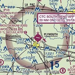
| Sectional chart |
|---|
|
| Airport distance calculator |
|---|
|
|
| Sunrise and sunset |
|---|
|
Times for 23-Jul-2026
| | Local
(UTC-4) | | Zulu
(UTC) |
|---|
| Morning civil twilight | | 06:01 | | 10:01 |
| Sunrise | | 06:33 | | 10:33 |
| Sunset | | 21:11 | | 01:11 |
| Evening civil twilight | | 21:43 | | 01:43 |
|
| Current date and time |
|---|
| Zulu (UTC) | 24-Jul-2026 03:15:09 |
|---|
| Local (UTC-4) | 23-Jul-2026 23:15:09 |
|---|
|
| METAR |
|---|
| KC65 | 240255Z AUTO 35003KT 10SM CLR 18/16 A3018 RMK A01
|
KOXI
17nm W | 240255Z AUTO 05002KT 10SM CLR 15/15 A3018 RMK AO2
|
KRCR
19nm S | 240255Z AUTO 10SM CLR 16/13 A3018 RMK AO2
|
|
| TAF |
|---|
KSBN
20nm N | 231730Z 2318/2418 VRB03KT P6SM BKN050 FM232100 36005KT P6SM SCT050 FM240000 VRB02KT P6SM SCT250
|
|
| NOTAMs |
|---|
NOTAMs are issued by the DoD/FAA and will open in a separate window not controlled by AirNav.
|
|

