FAA INFORMATION EFFECTIVE 17 APRIL 2025
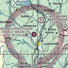
Location
| FAA Identifier: | CDA |
| Lat/Long: | 44-34-08.8110N 072-01-04.7240W
44-34.146850N 072-01.078733W
44.5691142,-72.0179789
(estimated) |
| Elevation: | 1187.6 ft. / 362.0 m (surveyed) |
| Variation: | 16W (1995) |
| From city: | 3 miles N of LYNDONVILLE, VT |
| Time zone: | UTC -4 (UTC -5 during Standard Time) |
| Zip code: | 05851 |
Airport Operations
| Airport use: | Open to the public |
| Activation date: | 08/1969 |
| Control tower: | no |
| ARTCC: | BOSTON CENTER |
| FSS: | BURLINGTON FLIGHT SERVICE STATION |
| NOTAMs facility: | BTV (NOTAM-D service available) |
| Attendance: | JAN-DEC MON-FRI 0700-1530 |
| Pattern altitude: | 2199.6 ft. MSL |
| Wind indicator: | lighted |
| Segmented circle: | yes |
| Lights: | ACTVT REIL RWY 02; MIRL RWY 02/20 - CTAF. |
| Beacon: | white-green (lighted land airport)
ACTVT ARPT ROTG BCN - CTAF. |
Airport Communications
| CTAF/UNICOM: | 122.8 |
| WX AWOS-3: | 119.275 (802-626-4532) |
- APCH/DEP SVC PRVDD BY BOSTON ARTCC ON FREQS 135.7/282.2 (BERLIN RCAG).
Nearby radio navigation aids
| VOR radial/distance | | VOR name | | Freq | | Var |
|---|
| MPVr049/34.4 | | MONTPELIER VOR/DME | | 116.90 | | 16W |
| NDB name | | Hdg/Dist | | Freq | | Var | | ID |
|---|
| MAHN | | 328/18.9 | | 386 | | 17W | | GMA | --. -- .- |
Airport Services
| Parking: | tiedowns |
| Bottled oxygen: | NONE |
| Bulk oxygen: | NONE |
Runway Information
Runway 2/20
| Dimensions: | 3302 x 60 ft. / 1006 x 18 m |
| Surface: | asphalt, in poor condition
PAVEMENT HAS NMRS SEALED, LRG DIAM TRANSVERSE CRACKS. |
| Weight bearing capacity: | |
| Runway edge lights: | medium intensity |
| RUNWAY 2 | | RUNWAY 20 |
| Latitude: | 44-33.878172N | | 44-34.415643N |
| Longitude: | 072-01.134377W | | 072-01.022675W |
| Elevation: | 1177.8 ft. | | 1187.6 ft. |
| Traffic pattern: | left | | left |
| Runway heading: | 024 magnetic, 008 true | | 204 magnetic, 188 true |
| Markings: | nonprecision, in good condition | | nonprecision, in good condition |
| Runway end identifier lights: | yes | | |
| Touchdown point: | yes, no lights | | yes, no lights |
| Obstructions: | 19 ft. trees, 353 ft. from runway, 214 ft. left of centerline, 8:1 slope to clear
+50 FT TREES 353 FT FM RWY END. | | 75 ft. trees, 1612 ft. from runway, 230 ft. left of centerline, 18:1 slope to clear |
Airport Ownership and Management from official FAA records
| Ownership: | Publicly-owned |
| Owner: | STATE OF VERMONT
219 N MAIN ST
BARRE, VT 05641
Phone 802-279-9746 |
| Manager: | EDDIE MIDDLETON
219 N MAIN ST
BARRE, VT 05641
Phone 802-279-9746 |
Additional Remarks
| - | RWY CONDS MAY NOT BE MNT OR RPRTD WHEN ARPT IS UNATNDD. |
| - | BRING OWN TIE DOWN ROPES. |
| - | FOR EMERG ACFT MAINT CALL 802-334-5001. |
| - | DEER & WILDLIFE ON & INVOF ARPT. |
| - | RISING TRRN 600 FT FM THR OF RWY 02. |
| - | BALD EAGLES ROOSTING INVOF COMPOST OPN LCTD 600 FT E OF RWY 20 THR YEAR-ROUND. |
| - | FOR CD CTC BOSTON ARTCC AT 603-879-6859. |
Instrument Procedures
NOTE: All procedures below are presented as PDF files. If you need a reader for these files, you should download the free Adobe Reader.NOT FOR NAVIGATION. Please procure official charts for flight.
FAA instrument procedures published for use from 17 April 2025 at 0901Z to 15 May 2025 at 0900z.
IAPs - Instrument Approach Procedures |
|---|
| RNAV (GPS) RWY 02 | |
download (196KB) |
| NOTE: Special Alternate Minimums apply | |
download (25KB) |
| NOTE: Special Take-Off Minimums/Departure Procedures apply | |
download (252KB) |
Other nearby airports with instrument procedures:
KEFK - Northeast Kingdom International Airport (21 nm NW)
KHIE - Mount Washington Regional Airport (24 nm SE)
KMVL - Morrisville-Stowe State Airport (26 nm W)
5B9 - Dean Memorial Airport (29 nm S)
KMPV - Edward F Knapp State Airport (32 nm SW)
|
|

Road maps at:
MapQuest
Bing
Google
| Aerial photo |
|---|
WARNING: Photo may not be current or correct

Do you have a better or more recent aerial photo of Caledonia County Airport that you would like to share? If so, please send us your photo.
|
| Sectional chart |
|---|
|
| Airport distance calculator |
|---|
|
|
| Sunrise and sunset |
|---|
|
Times for 03-May-2025
| | Local
(UTC-4) | | Zulu
(UTC) |
|---|
| Morning civil twilight | | 05:04 | | 09:04 |
| Sunrise | | 05:37 | | 09:37 |
| Sunset | | 19:53 | | 23:53 |
| Evening civil twilight | | 20:26 | | 00:26 |
|
| Current date and time |
|---|
| Zulu (UTC) | 03-May-2025 04:07:46 |
|---|
| Local (UTC-4) | 03-May-2025 00:07:46 |
|---|
|
| METAR |
|---|
| KCDA | 030355Z AUTO 00000KT 10SM BKN046 OVC060 15/14 A2985 RMK AO2 T01450137
|
K1V4
9nm S | 030354Z AUTO 14/12 A2981 RMK AO1 SLP093 T01390117
|
|
| TAF |
|---|
KEFK
23nm N | 021729Z 0218/0318 19008G15KT P6SM BKN045 TEMPO 0218/0220 OVC022 FM022000 22010G18KT P6SM VCSH SCT022 BKN040 FM030800 28005KT P6SM BKN035 FM031200 30006KT P6SM BKN025 FM031500 30005KT P6SM -SHRA OVC020
|
KHIE
23nm SE | 021723Z 0218/0318 09005KT P6SM VCSH BKN007 OVC018 FM030200 22003KT P6SM SCT070 FM030500 VRB03KT 5SM BR SCT060 FM031300 28005KT P6SM OVC022
|
|
| NOTAMs |
|---|
NOTAMs are issued by the DoD/FAA and will open in a separate window not controlled by AirNav.
|
|


