FAA INFORMATION EFFECTIVE 19 FEBRUARY 2026
Location
| FAA Identifier: | MVL |
| Lat/Long: | 44-32-03.6770N 072-36-50.3710W
44-32.061283N 072-36.839517W
44.5343547,-72.6139919
(estimated) |
| Elevation: | 732.9 ft. / 223.4 m (surveyed) |
| Variation: | 16W (1995) |
| From city: | 2 miles SW of MORRISVILLE, VT |
| Time zone: | UTC -5 (UTC -4 during Daylight Saving Time) |
| Zip code: | 05661 |
Airport Operations
| Airport use: | Open to the public |
| Activation date: | 07/1960 |
| Control tower: | no |
| ARTCC: | BOSTON CENTER |
| FSS: | BURLINGTON FLIGHT SERVICE STATION |
| NOTAMs facility: | MVL (NOTAM-D service available) |
| Attendance: | UNATNDD |
| Wind indicator: | lighted |
| Segmented circle: | yes |
| Lights: | ACTVT REIL RWYS 01 & 19; PAPI RWY 19; HIRL RWY 01/19 - CTAF. |
| Beacon: | white-green (lighted land airport)
Operates sunset to sunrise. |
Airport Communications
| CTAF/UNICOM: | 122.8 |
| WX ASOS: | 135.625 (802-888-7934) |
| WX ASOS at MPV (20 nm S): | 132.675 (802-229-2037) |
- APCH/DEP SVC PRVDD BY BOSTON ARTCC ON FREQS 135.7/282.2 (MONTPELIER RCAG).
Nearby radio navigation aids
| VOR radial/distance | | VOR name | | Freq | | Var |
|---|
| BTVr086/25.7 | | BURLINGTON VOR/DME | | 117.50 | | 15W |
| MPVr001/27.8 | | MONTPELIER VOR/DME | | 116.90 | | 16W |
Airport Services
| Fuel available: | 100LL JET-A
100LL:SELF SVC ONLY.
A:SELF SVC ONLY. |
| Parking: | tiedowns |
| Airframe service: | NONE |
| Powerplant service: | NONE |
| Bottled oxygen: | NONE |
| Bulk oxygen: | NONE |
Runway Information
Runway 1/19
| Dimensions: | 4200 x 75 ft. / 1280 x 23 m |
| Surface: | asphalt, in excellent condition |
| Weight bearing capacity: | | PCN 12 /F/A/X/T | | Single wheel: | 25.0 |
|
| Runway edge lights: | high intensity |
| RUNWAY 1 | | RUNWAY 19 |
| Latitude: | 44-31.715828N | | 44-32.406750N |
| Longitude: | 072-36.825775W | | 072-36.853250W |
| Elevation: | 713.0 ft. | | 731.8 ft. |
| Traffic pattern: | left | | left |
| Runway heading: | 014 magnetic, 358 true | | 194 magnetic, 178 true |
| Displaced threshold: | 250 ft. | | 250 ft. |
| Markings: | nonprecision, in good condition | | nonprecision, in good condition |
| Visual slope indicator: | | | 2-light PAPI on left (3.50 degrees glide path) |
| Runway end identifier lights: | yes | | yes |
| Touchdown point: | yes, no lights | | yes, no lights |
| Obstructions: | 15 ft. trees, 201 ft. from runway, 250 ft. left and right of centerline
CLOSE-IN OBSTN 15 FT TREES, 99-199 FT, 225 FT R. | | none
CLOSE-IN OBSTN 5 FT FENCE, 70 FT, 250 FT L/R; 4 FT CONC WALL, 33 FT, 129 FT R. |
Airport Ownership and Management from official FAA records
| Ownership: | Publicly-owned |
| Owner: | STATE OF VERMONT
219 N MAIN ST
BARRE, VT 05641
Phone 802-279-7146 |
| Manager: | EDDIE MIDDLETON
219 N MAIN ST
BARRE, VT 05641
Phone 802-279-9746 |
Additional Remarks
| - | RWY CONDS NOT MNT WHEN UNATNDD. |
| - | 3 FT SWALES MID 1/3 OF RWY ON E & W SIDES OUTSIDE OF RWY SAFETY AREA. |
| - | COLD TEMPERATURE AIRPORT. ALTITUDE CORRECTION REQUIRED AT OR BELOW -19C. |
| - | FOR CD CTC BOSTON ARTCC AT 603-879-6859. |
Instrument Procedures
NOTE: All procedures below are presented as PDF files. If you need a reader for these files, you should download the free Adobe Reader.NOT FOR NAVIGATION. Please procure official charts for flight.
FAA instrument procedures published for use from 19 February 2026 at 0901Z to 19 March 2026 at 0900Z.
IAPs - Instrument Approach Procedures |
|---|
| RNAV (GPS) Y RWY 19 | |
download (233KB) |
| RNAV (GPS) Z RWY 19 | |
download (270KB) |
| RNAV (GPS)-A | |
download (202KB) |
| NOTE: Special Alternate Minimums apply | |
download (153KB) |
| NOTE: Special Take-Off Minimums/Departure Procedures apply | |
download (178KB) |
Other nearby airports with instrument procedures:
KMPV - Edward F Knapp State Airport (20 nm S)
KBTV - Patrick Leahy Burlington International Airport (23 nm W)
KCDA - Caledonia County Airport (26 nm E)
KEFK - Northeast Kingdom International Airport (27 nm NE)
KFSO - Franklin County State Airport (32 nm NW)
|
|

Road maps at:
MapQuest
Bing
Google
| Aerial photo |
|---|
WARNING: Photo may not be current or correct
 Photo by Pete Chaisson- Portland Flight Services
Taken in September 2014
looking southwest.
Photo by Pete Chaisson- Portland Flight Services
Taken in September 2014
looking southwest.
Do you have a better or more recent aerial photo of Morrisville-Stowe State Airport that you would like to share? If so, please send us your photo.
|
| Sectional chart |
|---|
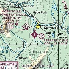
|
| Airport distance calculator |
|---|
|
|
| Sunrise and sunset |
|---|
|
Times for 04-Mar-2026
| | Local
(UTC-5) | | Zulu
(UTC) |
|---|
| Morning civil twilight | | 05:55 | | 10:55 |
| Sunrise | | 06:24 | | 11:24 |
| Sunset | | 17:41 | | 22:41 |
| Evening civil twilight | | 18:10 | | 23:10 |
|
| Current date and time |
|---|
| Zulu (UTC) | 05-Mar-2026 03:47:05 |
|---|
| Local (UTC-5) | 04-Mar-2026 22:47:05 |
|---|
|
| METAR |
|---|
KMVL
2nm S | 050254Z AUTO 00000KT 10SM CLR M03/M06 A3022 RMK AO2 SLP242 T10331056 53011
|
|
| TAF |
|---|
KMPV
20nm S | 041732Z 0418/0518 VRB03KT P6SM SKC FM050800 00000KT 5SM BR BKN060 FM051100 00000KT 3SM BR BKN025 FM051700 VRB03KT P6SM BKN035
|
KBTV
23nm W | 041732Z 0418/0518 20008KT P6SM SKC FM050700 00000KT 6SM BR SCT070 FM050900 00000KT 3SM BR BCFG BKN025 FM051200 34005KT 3SM BR BKN016 FM051400 33007KT P6SM BKN016
|
|
| NOTAMs |
|---|
NOTAMs are issued by the DoD/FAA and will open in a separate window not controlled by AirNav.
|
|

