FAA INFORMATION EFFECTIVE 04 SEPTEMBER 2025
Location
| FAA Identifier: | FSO |
| Lat/Long: | 44-56-25.0000N 073-05-50.9000W
44-56.416667N 073-05.848333W
44.9402778,-73.0974722
(estimated) |
| Elevation: | 227.9 ft. / 69.5 m (surveyed) |
| Variation: | 16W (1995) |
| From city: | 3 miles W of HIGHGATE, VT |
| Time zone: | UTC -4 (UTC -5 during Standard Time) |
| Zip code: | 05488 |
Airport Operations
| Airport use: | Open to the public |
| Activation date: | 07/1970 |
| Control tower: | no |
| ARTCC: | BOSTON CENTER |
| FSS: | BURLINGTON FLIGHT SERVICE STATION |
| NOTAMs facility: | BTV (NOTAM-D service available) |
| Attendance: | NOV-MAR M-F 0830-1700, APR-OCT M-F 0730-1700 |
| Wind indicator: | lighted |
| Segmented circle: | yes |
| Lights: | DUSK-DAWN. ACTVT REIL RWYS 01 & 19; PAPI RWY 01; MIRL RWY 01/19 - CTAF. |
| Beacon: | white-green (lighted land airport)
Operates sunset to sunrise. |
| International operations: | customs landing rights airport |
Airport Communications
| CTAF/UNICOM: | 122.8 |
| WX AWOS-3: | 119.025 (802-868-9941) |
| BURLINGTON APPROACH: | 121.1 [0530-0000] |
| BURLINGTON DEPARTURE: | 121.1 [0530-0000] |
- APCH/DEP SVC PRVDD BY BOSTON ARTCC ON FREQS 120.35/342.25 (ST. ALBANS RCAG) WHEN BURLINGTON APCH CTL CLSD.
Nearby radio navigation aids
| VOR radial/distance | | VOR name | | Freq | | Var |
|---|
| BTVr021/32.8 | | BURLINGTON VOR/DME | | 117.50 | | 15W |
Airport Services
| Fuel available: | 100LL JET-A1+
100LL:FUEL AVBL 24 HRS SELF-SERVE. AFT HRS SELF-SERVE FUEL KIOSK DOES NOT ACPT MASTERCARD. |
| Parking: | hangars and tiedowns |
| Airframe service: | MAJOR |
| Powerplant service: | MAJOR |
| Bottled oxygen: | NONE |
| Bulk oxygen: | NONE |
Runway Information
Runway 1/19
| Dimensions: | 3001 x 60 ft. / 915 x 18 m |
| Surface: | asphalt, in good condition |
| Weight bearing capacity: | |
| Runway edge lights: | medium intensity |
| RUNWAY 1 | | RUNWAY 19 |
| Latitude: | 44-56.173935N | | 44-56.659502N |
| Longitude: | 073-05.783992W | | 073-05.911120W |
| Elevation: | 227.6 ft. | | 227.7 ft. |
| Traffic pattern: | left | | left |
| Runway heading: | 005 magnetic, 349 true | | 185 magnetic, 169 true |
| Markings: | nonprecision, in good condition | | nonprecision, in good condition |
| Visual slope indicator: | 2-light PAPI on left (4.00 degrees glide path) | | |
| Runway end identifier lights: | yes | | yes |
| Touchdown point: | yes, no lights | | yes, no lights |
| Obstructions: | 93 ft. trees, 1771 ft. from runway, 250 ft. left of centerline, 16:1 slope to clear | | 27 ft. trees, 580 ft. from runway, 27 ft. right of centerline, 14:1 slope to clear |
Airport Ownership and Management from official FAA records
| Ownership: | Publicly-owned |
| Owner: | STATE OF VERMONT
219 N MAIN ST
BARRE, VT 05641
Phone 802-279-9746 |
| Manager: | EDDIE MIDDLETON
219 N MAIN ST
BARRE, VT 05641
Phone 802-585-5586 |
Additional Remarks
| A39-01/19 | PCR VALUE: 200/F/C/X/T |
| - | RWY CONDS MAY NOT BE MNT OR RPRTD WHEN ARPT IS UNATNDD. |
| - | MIL EQPT MAY BE NEAR RWY. |
| - | SEAGULLS INVOF ARPT. |
| - | FOR CD CTC BURLINGTON APCH AT 802-657-4413, WHEN APCH CLSD CTC BOSTON ARTCC AT 603-879-6859. |
Instrument Procedures
NOTE: All procedures below are presented as PDF files. If you need a reader for these files, you should download the free Adobe Reader.NOT FOR NAVIGATION. Please procure official charts for flight.
FAA instrument procedures published for use from 04 September 2025 at 0901Z to 02 October 2025 at 0900z.
IAPs - Instrument Approach Procedures |
|---|
| RNAV (GPS) RWY 01 | |
download (216KB) |
| RNAV (GPS) RWY 19 | |
download (187KB) |
| NOTE: Special Alternate Minimums apply | |
download (128KB) |
| NOTE: Special Take-Off Minimums/Departure Procedures apply | |
download (178KB) |
Other nearby airports with instrument procedures:
KPBG - Plattsburgh International Airport (23 nm SW)
KBTV - Patrick Leahy Burlington International Airport (28 nm S)
KMVL - Morrisville-Stowe State Airport (32 nm SE)
KEFK - Northeast Kingdom International Airport (37 nm E)
KMPV - Edward F Knapp State Airport (50 nm SE)
|
|

Road maps at:
MapQuest
Bing
Google
| Aerial photo |
|---|
WARNING: Photo may not be current or correct
 Photo by Pete Chaisson Portland Flight Services
Photo taken 19-Aug-2014
looking east.
Photo by Pete Chaisson Portland Flight Services
Photo taken 19-Aug-2014
looking east.
Do you have a better or more recent aerial photo of Franklin County State Airport that you would like to share? If so, please send us your photo.
|
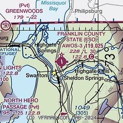
| Sectional chart |
|---|
|
| Airport distance calculator |
|---|
|
|
| Sunrise and sunset |
|---|
|
Times for 13-Sep-2025
| | Local
(UTC-4) | | Zulu
(UTC) |
|---|
| Morning civil twilight | | 06:00 | | 10:00 |
| Sunrise | | 06:30 | | 10:30 |
| Sunset | | 19:07 | | 23:07 |
| Evening civil twilight | | 19:37 | | 23:37 |
|
| Current date and time |
|---|
| Zulu (UTC) | 13-Sep-2025 15:36:30 |
|---|
| Local (UTC-4) | 13-Sep-2025 11:36:30 |
|---|
|
| METAR |
|---|
| KFSO | 131515Z AUTO 19003KT 10SM SCT050 SCT070 SCT120 17/10 A3010 RMK AO2 T01720099
|
CWFQ
13nm NE | 131500Z AUTO 16002KT 16/10 RMK AO1 SLP195 T01550103 58004
|
|
| TAF |
|---|
KPBG
23nm SW | 131121Z 1312/1412 VRB03KT P6SM OVC150 FM131500 15008KT P6SM BKN070 PROB30 1315/1318 -SHRA FM132300 VRB03KT P6SM SCT100
|
KBTV
29nm S | 131121Z 1312/1412 VRB03KT P6SM BKN150 FM131400 19007KT P6SM BKN070 OVC120 PROB30 1315/1318 -SHRA FM132300 VRB03KT P6SM SCT100
|
|
| NOTAMs |
|---|
NOTAMs are issued by the DoD/FAA and will open in a separate window not controlled by AirNav.
|
|

