FAA INFORMATION EFFECTIVE 19 MARCH 2026
Location
| FAA Identifier: | HIE |
| Lat/Long: | 44-22-03.2000N 071-32-44.9000W
44-22.053333N 071-32.748333W
44.3675556,-71.5458056
(estimated) |
| Elevation: | 1072 ft. / 326.7 m (surveyed) |
| Variation: | 17W (1995) |
| From city: | 3 miles E of WHITEFIELD, NH |
| Time zone: | UTC -4 (UTC -5 during Standard Time) |
| Zip code: | 03583 |
Airport Operations
| Airport use: | Open to the public |
| Activation date: | 08/1946 |
| Control tower: | no |
| ARTCC: | BOSTON CENTER |
| FSS: | BANGOR FLIGHT SERVICE STATION |
| NOTAMs facility: | HIE (NOTAM-D service available) |
| Attendance: | IREG |
| Pattern altitude: | 2072 ft. MSL |
| Wind indicator: | lighted |
| Segmented circle: | yes |
| Lights: | ACTVT REIL RWYS 10 & 28; PAPI RWY 10; MIRL RWY 10/28 - CTAF. |
| Beacon: | white-green (lighted land airport)
Operates sunset to sunrise. |
| Landing fee: | yes, CTC ARPT FOR OVNGT PRKG. FEES VARY, SNGL ENG, MULTI ENG, COML. 1 NGT WAIVED WITH FUEL PURCHASE. |
Airport Communications
| CTAF/UNICOM: | 122.8 |
| WX ASOS: | 118.525 (603-837-2769) |
- APCH/DEP SVC PRVDD BY BOSTON ARTCC ON FREQS 135.7/282.2(MONTPELIER RCAG).
Nearby radio navigation aids
| NDB name | | Hdg/Dist | | Freq | | Var | | ID |
|---|
| MAHN | | 104/6.0 | | 386 | | 17W | | GMA | --. -- .- |
Airport Services
| Fuel available: | 100LL
100LL:FUEL SELF SVC AVBL 24 HRS WITH CREDIT CARD. |
| Parking: | tiedowns |
| Airframe service: | MAJOR |
| Powerplant service: | MAJOR |
Runway Information
Runway 10/28
| Dimensions: | 4001 x 75 ft. / 1220 x 23 m |
| Surface: | asphalt, in fair condition |
| Weight bearing capacity: | |
| Runway edge lights: | medium intensity |
| RUNWAY 10 | | RUNWAY 28 |
| Latitude: | 44-22.036852N | | 44-22.069652N |
| Longitude: | 071-33.207093W | | 071-32.290170W |
| Elevation: | 1048.2 ft. | | 1072.0 ft. |
| Traffic pattern: | left | | right |
| Runway heading: | 104 magnetic, 087 true | | 284 magnetic, 267 true |
| Markings: | nonprecision, in good condition | | nonprecision, in good condition |
| Visual slope indicator: | 4-light PAPI on left (3.50 degrees glide path) | | |
| Runway end identifier lights: | yes | | yes |
| Touchdown point: | yes, no lights | | yes, no lights |
| Instrument approach: | LOCALIZER | | |
| Obstructions: | none | | 62 ft. trees, 791 ft. from runway, 257 ft. left of centerline, 9:1 slope to clear |
Airport Ownership and Management from official FAA records
| Ownership: | Publicly-owned |
| Owner: | TOWN OF WHITEFIELD
56 LITTLETON RD
WHITEFIELD, NH 03598
Phone 603-837-2551 |
| Manager: | JAY ENNIS
56 LITTLETON RD
WHITEFIELD, NH 03598
Phone 603-837-9532
AMGR CELL: 603-837-9532. EMAIL: MTWASHINGTONREGIONALAIRPORT@GMAIL.COM. |
Additional Remarks
| - | RWY 28 TRANS LINE ACRS APCH 20:1+, MKD WITH DAY-GLOW BALLS. |
| - | WILDLIFE ON & INVOF ARPT. |
| - | COLD TEMPERATURE AIRPORT. ALTITUDE CORRECTION REQUIRED AT OR BELOW -28C. |
| - | RENTAL CAR AVBL BY REQ, WWW.MOUNTWASHINGTONAIRPORT.COM. |
| - | FOR CD IF UNA TO CTC ON FSS FREQ, CTC BOSTON ARTCC AT 603-879-6859. |
| - | ARPT CONDS NOT RGLRLY MNT. |
| - | RISING TRRN LCTD 3 NM SE OF ARPT. |
Instrument Procedures
NOTE: All procedures below are presented as PDF files. If you need a reader for these files, you should download the free Adobe Reader.NOT FOR NAVIGATION. Please procure official charts for flight.
FAA instrument procedures published for use from 19 March 2026 at 0901Z to 16 April 2026 at 0900Z.
IAPs - Instrument Approach Procedures |
|---|
| RNAV (GPS) Y RWY 10 | |
download (318KB) |
| RNAV (GPS) Z RWY 10 | |
download (320KB) |
| NOTE: Special Alternate Minimums apply | |
download (30KB) |
| NOTE: Special Take-Off Minimums/Departure Procedures apply | |
download (178KB) |
Other nearby airports with instrument procedures:
KBML - Berlin Regional Airport (20 nm NE)
KCDA - Caledonia County Airport (24 nm NW)
5B9 - Dean Memorial Airport (26 nm SW)
0B1 - Bethel Regional Airport (32 nm E)
KIZG - White Mountain Regional Airport (34 nm SE)
|
|

Road maps at:
MapQuest
Bing
Google
| Aerial photo |
|---|
WARNING: Photo may not be current or correct
 Photo by NPA Photos
Photo taken 15-Mar-2020
looking southeast.
Photo by NPA Photos
Photo taken 15-Mar-2020
looking southeast.
Do you have a better or more recent aerial photo of Mount Washington Regional Airport that you would like to share? If so, please send us your photo.
|
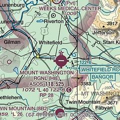
| Sectional chart |
|---|
|
CAUTION: Diagram may not be current

| Airport distance calculator |
|---|
|
|
| Sunrise and sunset |
|---|
|
Times for 20-Mar-2026
| | Local
(UTC-4) | | Zulu
(UTC) |
|---|
| Morning civil twilight | | 06:21 | | 10:21 |
| Sunrise | | 06:50 | | 10:50 |
| Sunset | | 18:57 | | 22:57 |
| Evening civil twilight | | 19:26 | | 23:26 |
|
| Current date and time |
|---|
| Zulu (UTC) | 21-Mar-2026 03:55:04 |
|---|
| Local (UTC-4) | 20-Mar-2026 23:55:04 |
|---|
|
| METAR |
|---|
| KHIE | 210338Z AUTO 00000KT 7SM OVC009 00/M01 A2973 RMK AO2 CIG 004V010 T00001006
|
KMWN
13nm SE | 210251Z 26037KT 0SM FZFG VV000 M04/M04 RMK VRY LGT ICG AND GICG
|
|
| TAF |
|---|
| KHIE | 210146Z 2102/2124 00000KT P6SM OVC015 FM210400 00000KT P6SM SCT001 OVC007 FM211000 VRB04KT P6SM BKN006 FM211500 31007KT P6SM BKN019 FM211700 31008KT P6SM SCT018
|
|
| NOTAMs |
|---|
NOTAMs are issued by the DoD/FAA and will open in a separate window not controlled by AirNav.
|
|


