FAA INFORMATION EFFECTIVE 09 JULY 2026
Location
| FAA Identifier: | 0B1 |
| Lat/Long: | 44-25-30.6000N 070-48-35.7000W
44-25.510000N 070-48.595000W
44.4251667,-70.8099167
(estimated) |
| Elevation: | 674 ft. / 205.4 m (surveyed) |
| Variation: | 17W (1985) |
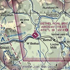
| From city: | 2 miles NW of BETHEL, ME |
| Time zone: | UTC -4 (UTC -5 during Standard Time) |
| Zip code: | 04217 |
Airport Operations
| Airport use: | Open to the public |
| Activation date: | 12/2001 |
| Control tower: | no |
| ARTCC: | BOSTON CENTER |
| FSS: | BANGOR FLIGHT SERVICE STATION |
| NOTAMs facility: | BGR (NOTAM-D service available) |
| Attendance: | UNATNDD |
| Wind indicator: | lighted, LGTD WINDSOCK AND APN LGTS ON CONSLY AT NGT. |
| Segmented circle: | yes |
| Lights: | ACTVT REIL RWY 32; MIRL RWY 14/32 - CTAF. |
| Beacon: | white-green (lighted land airport)
Operates sunset to sunrise. |
Airport Communications
| CTAF: | 122.9 |
| WX AWOS-AV: | 119.075 (207-512-2516) |
| PORTLAND APPROACH: | 125.5 |
| PORTLAND DEPARTURE: | 125.5 |
| WX ASOS at BML (18 nm NW): | 135.175 (603-449-3328) |
- APCH/DEP SVC PRVDD BY BOSTON ARTCC ON FREQS 128.2/263.05 (WATERBORO RCAG) WHEN PORTLAND APCH CTL CLSD.
Nearby radio navigation aids
| NDB name | | Hdg/Dist | | Freq | | Var | | ID |
|---|
| MAHN | | 101/37.7 | | 386 | | 17W | | GMA | --. -- .- |
Airport Services
| Fuel available: | 100LL
100LL:SELF-SERVE AVBL 24 HRS WITH CREDIT CARD. |
| Parking: | tiedowns |
| Airframe service: | NONE |
| Powerplant service: | NONE |
| Bottled oxygen: | NONE |
| Bulk oxygen: | NONE |
Runway Information
Runway 14/32
| Dimensions: | 3818 x 75 ft. / 1164 x 23 m |
| Surface: | asphalt, in good condition |
| Runway edge lights: | medium intensity |
| RUNWAY 14 | | RUNWAY 32 |
| Latitude: | 44-25.694830N | | 44-25.323515N |
| Longitude: | 070-48.948492W | | 070-48.241258W |
| Elevation: | 674.0 ft. | | 656.2 ft. |
| Traffic pattern: | left | | left |
| Markings: | basic, in fair condition | | nonprecision, in fair condition |
| Runway end identifier lights: | | | yes |
| Touchdown point: | yes, no lights | | yes, no lights |
| Obstructions: | 18 ft. tree, 296 ft. from runway, 199 ft. right of centerline, 5:1 slope to clear | | none |
Airport Ownership and Management from official FAA records
| Ownership: | Publicly-owned |
| Owner: | TOWN OF BETHEL
PO BOX 1660
BETHEL, ME 04217
Phone 207-824-2669 |
| Manager: | RANDY AUTREY
TOWN OF BETHEL, PO BOX 1660
BETHEL, ME 04217
Phone 207-381-0202
EMERG (POLICE) 1-800-733-1421. |
Additional Remarks
| - | TURKEYS & GEESE ON OR INVOF ARPT. |
| - | FOR CD CTC PORTLAND APCH AT 207-874-7320, WHEN APCH CLSD CTC BOSTON ARTCC AT 603-879-6859. |
| - | COLD TEMPERATURE AIRPORT. ALTITUDE CORRECTION REQUIRED AT OR BELOW -22C. |
| - | UNLGTD MTUS TRRN. |
| - | FOR RWY CONDS OR OTHER INFO, CTC ARPT INFO LINE 207-512-5552. |
| - | PWRD PRCHT ACTVTY OCNLY IN TRML AREA. |
| - | FEES FOR PRKG & TIE-DOWNS. ELEC HOOK-UP AVBL. |
| - | ARPT SFC CONDS UNMON BTN 0200-1300Z DLY. |
| - | UAS WI 3 NM RDS OF ARPT SFC-400 FT AGL DLY, SR-SS. |
Instrument Procedures
NOTE: All procedures below are presented as PDF files. If you need a reader for these files, you should download the free Adobe Reader.NOT FOR NAVIGATION. Please procure official charts for flight.
FAA instrument procedures published for use from 09 July 2026 at 0901Z to 06 August 2026 at 0900Z.
IAPs - Instrument Approach Procedures |
|---|
| RNAV (GPS) Z RWY 32 | |
download (217KB) |
| NOTE: Special Take-Off Minimums/Departure Procedures apply | |
download (388KB) |
Other nearby airports with instrument procedures:
KBML - Berlin Regional Airport (18 nm NW)
81B - Oxford County Regional Airport (21 nm SE)
KIZG - White Mountain Regional Airport (27 nm S)
KHIE - Mount Washington Regional Airport (32 nm W)
KLEW - Auburn/Lewiston Municipal Airport (32 nm SE)
|
|

Road maps at:
MapQuest
Bing
Google
| Aerial photo |
|---|
WARNING: Photo may not be current or correct
 Photo by Pete Chaisson Portland Flight Services
Photo taken 15-Aug-2014
looking southeast.
Photo by Pete Chaisson Portland Flight Services
Photo taken 15-Aug-2014
looking southeast.
Do you have a better or more recent aerial photo of Bethel Regional Airport that you would like to share? If so, please send us your photo.
|
| Sectional chart |
|---|
|
| Airport distance calculator |
|---|
|
|
| Sunrise and sunset |
|---|
|
Times for 03-Aug-2026
| | Local
(UTC-4) | | Zulu
(UTC) |
|---|
| Morning civil twilight | | 05:00 | | 09:00 |
| Sunrise | | 05:33 | | 09:33 |
| Sunset | | 20:05 | | 00:05 |
| Evening civil twilight | | 20:38 | | 00:38 |
|
| Current date and time |
|---|
| Zulu (UTC) | 03-Aug-2026 11:57:25 |
|---|
| Local (UTC-4) | 03-Aug-2026 07:57:25 |
|---|
|
| METAR |
|---|
KBML
19nm NW | 031152Z AUTO VRB03KT 10SM FEW044 SCT055 BKN080 21/19 A2976 RMK AO2 RAE46 SLP072 P0003 60010 70010 T02060194 10217 20200 58015
|
KMWN
22nm SW | 031054Z 18030G40KT 0SM RA FG VV000 13/13 RMK
|
KIZG
27nm S | 031154Z AUTO 00000KT 2SM RA BR BKN004 BKN010 OVC017 21/20 A2975 RMK AO2 VIS 1V5 SLP072 P0040 60172 70172 T02110200 10228 20206 58021 $
|
KHIE
32nm W | 031152Z AUTO 35004KT 10SM FEW035 SCT047 BKN055 21/19 A2973 RMK AO2 RAE11 SLP064 P0001 60011 70011 T02110194 10228 20189 58017
|
K8B0
33nm N | 031155Z AUTO 12006KT 3SM -RA SCT010 BKN035 SCT040 18/18 A2981 RMK AO2 P0009
|
KLEW
33nm SE | 031056Z AUTO 14005KT 5SM -RA BR OVC004 20/20 A2980 RMK AO2 SLP095 T02000200 PNO $
|
|
| TAF |
|---|
KHIE
32nm W | 030945Z 0310/0406 28004KT P6SM -RA SCT040 BKN060 OVC080 FM031100 00000KT 5SM BR OVC025 FM031200 12005KT 2SM SHRA BR OVC008 FM031600 18007KT 5SM BR BKN015 FM040000 25014G25KT P6SM BKN025
|
|
| NOTAMs |
|---|
NOTAMs are issued by the DoD/FAA and will open in a separate window not controlled by AirNav.
|
|

