FAA INFORMATION EFFECTIVE 22 JANUARY 2026
Location
| FAA Identifier: | CUB |
| Lat/Long: | 33-58-13.7000N 080-59-42.9000W
33-58.228333N 080-59.715000W
33.9704722,-80.9952500
(estimated) |
| Elevation: | 193.4 ft. / 58.9 m (surveyed) |
| Variation: | 06W (1995) |
| From city: | 2 miles S of COLUMBIA, SC |
| Time zone: | UTC -5 (UTC -4 during Daylight Saving Time) |
| Zip code: | 29205 |
Airport Operations
| Airport use: | Open to the public |
| Activation date: | 08/1950 |
| Control tower: | no |
| ARTCC: | JACKSONVILLE CENTER |
| FSS: | ANDERSON FLIGHT SERVICE STATION |
| NOTAMs facility: | CUB (NOTAM-D service available) |
| Attendance: | 0600-2200
FOR SERVICE AFTER HRS CALL 803-771-7915. |
| Pattern altitude: | 1000.4 ft. MSL
TPA: 807 FT AGL / 1000 FT MSL. |
| Wind indicator: | lighted |
| Segmented circle: | yes |
| Lights: | ACTVT MIRL RY 13/31 AND REILS RYS 13 & 31 - CTAF. |
| Beacon: | white-green (lighted land airport)
Operates sunset to sunrise. |
Airport Communications
| CTAF/UNICOM: | 123.075 |
| WX ASOS: | 118.675 (803-929-0665) |
| COLUMBIA APPROACH: | 133.4 |
| COLUMBIA DEPARTURE: | 133.4 |
| CLEARANCE DELIVERY: | 124.4 |
| WX ASOS at CAE (6 nm W): | PHONE 803-369-6879 |
Nearby radio navigation aids
| VOR radial/distance | | VOR name | | Freq | | Var |
|---|
| CAEr025/7.4 | | COLUMBIA VORTAC | | 114.70 | | 02W |
| MMTr294/10.0 | | MC ENTIRE VORTAC | | 113.20 | | 08W |
| NDB name | | Hdg/Dist | | Freq | | Var | | ID |
|---|
| ENOREE | | 130/37.8 | | 278 | | 07W | | EOE | . --- . |
| AIKEN | | 067/39.0 | | 347 | | 06W | | AIK | .- .. -.- |
Airport Services
| Fuel available: | 100LL JET-A
100LL:CONTRACT FUEL FOR MILITARY. |
| Parking: | hangars and tiedowns |
| Airframe service: | MAJOR |
| Powerplant service: | MAJOR |
| Bulk oxygen: | HIGH/LOW |
Runway Information
Runway 13/31
| Dimensions: | 5011 x 75 ft. / 1527 x 23 m |
| Surface: | asphalt, in fair condition |
| Weight bearing capacity: | | PCN 15 /F/B/X/T | | Single wheel: | 44.5 | | Double wheel: | 66.0 |
|
| Runway edge lights: | medium intensity |
| RUNWAY 13 | | RUNWAY 31 |
| Latitude: | 33-58.467377N | | 33-57.988432N |
| Longitude: | 081-00.119555W | | 080-59.311278W |
| Elevation: | 193.4 ft. | | 182.4 ft. |
| Traffic pattern: | right | | left |
| Runway heading: | 131 magnetic, 125 true | | 311 magnetic, 305 true |
| Displaced threshold: | no | | 391 ft. |
| Declared distances: | TORA:4999 TODA:4999 ASDA:4999 LDA:4999
400 FT STWY NW END OF RY. | | TORA:4999 TODA:4999 ASDA:4999 LDA:4599 |
| Markings: | nonprecision, in good condition | | nonprecision, in good condition |
| Visual slope indicator: | 2-light PAPI on left (4.00 degrees glide path)
PAPI RWY 13 UNUSBL BYD 8 DEG RT. | | 2-light PAPI on right (3.00 degrees glide path) |
| Runway end identifier lights: | yes | | yes |
| Touchdown point: | yes, no lights | | yes, no lights |
| Instrument approach: | | | LOC/DME |
| Obstructions: | 77 ft. tree, 1096 ft. from runway, 148 ft. left of centerline, 11:1 slope to clear
RY 13 71 FT TREE 148 FT LEFT OF CNTRLN & 1096 FT FROM THLD, 40 FT POWER LINES 180 FT RIGHT OF CNTRLN & 958 FT FROM THLD, 30 FT BLDG 140 FT RIGHT & 900 FT FM THLD, 27 FT BLDG 653 FT FROM THLD & 172 FT LEFT. | | 64 ft. tree, 1053 ft. from runway, 353 ft. right of centerline, 13:1 slope to clear
RY 31, 18 FTTREES, 160 FT FM THLD 56 FT LEFT OF CENTERLINE. |
Airport Ownership and Management from official FAA records
| Ownership: | Publicly-owned |
| Owner: | COUNTY OF RICHLAND
PO BOX 192
COLUMBIA, SC 29202
Phone 803-748-4616 |
| Manager: | PETER CEVALLOS
1400 JIM HAMILTON BLVD
COLUMBIA, SC 29205
Phone 803-771-7915
FBO EAGLE AVIATION 803-771-7915. |
Additional Remarks
| - | RR SWITCHING YARD PARALLEL TO RY 13/31. |
| - | AVOID NOISE SENSITIVE AREA NORTH OF ARPT BLO 1500 FT. |
| - | NO NORTHBOUND DEP TURNS EITHER RY BLO 1500 FT. |
| - | RY TO TWY SEPARATION IS 206 FT. THE SEPARATION DESIGN CRITERION IS NOT FULLY MET FOR ACFT 12,500 LBS AND LARGER |
| - | DUE TO PROXIMITY AND RY ALIGNMENT, AIRCREWS HAVE MISTAKEN CAE (RY 11/29) FOR CUB (RY 13/31) WHICH IS 6 MILES SW. |
| - | FOR CD CTC COLUMBIA APCH AT 803-822-5242 OR 803-822-5040. |
Instrument Procedures
NOTE: All procedures below are presented as PDF files. If you need a reader for these files, you should download the free Adobe Reader.NOT FOR NAVIGATION. Please procure official charts for flight.
FAA instrument procedures published for use from 22 January 2026 at 0901Z to 19 February 2026 at 0900z.
IAPs - Instrument Approach Procedures |
|---|
| RNAV (GPS) RWY 13 | |
download (227KB) |
| RNAV (GPS) RWY 31 | |
download (234KB) |
| LOC RWY 31 | |
download (229KB) |
| NOTE: Special Take-Off Minimums/Departure Procedures apply | |
download (203KB) |
Other nearby airports with instrument procedures:
KCAE - Columbia Metro Airport (6 nm W)
KMMT - Mc Entire Joint National Guard Base (10 nm E)
6J0 - Lexington County Airport (16 nm SW)
KFDW - Fairfield County Airport (21 nm N)
KXNO - North Air Force Auxiliary Field (22 nm S)
|
|

Road maps at:
MapQuest
Bing
Google
| Aerial photo |
|---|
WARNING: Photo may not be current or correct
 Photo by King Martin
Photo taken 17-Mar-2011
looking northwest.
Photo by King Martin
Photo taken 17-Mar-2011
looking northwest.
Do you have a better or more recent aerial photo of Jim Hamilton L B Owens Airport that you would like to share? If so, please send us your photo.
|
| Sectional chart |
|---|
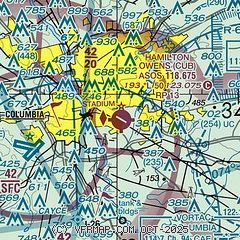
|
| Airport distance calculator |
|---|
|
|
| Sunrise and sunset |
|---|
|
Times for 25-Jan-2026
| | Local
(UTC-5) | | Zulu
(UTC) |
|---|
| Morning civil twilight | | 07:00 | | 12:00 |
| Sunrise | | 07:26 | | 12:26 |
| Sunset | | 17:46 | | 22:46 |
| Evening civil twilight | | 18:13 | | 23:13 |
|
| Current date and time |
|---|
| Zulu (UTC) | 26-Jan-2026 04:09:21 |
|---|
| Local (UTC-5) | 25-Jan-2026 23:09:21 |
|---|
|
| METAR |
|---|
| KCUB | 260353Z AUTO 00000KT 3SM RA BR OVC005 01/00 A2988 RMK AO2 UPB05E07B27E31 SLP120 P0006 T00060000
|
KCAE
6nm W | 260356Z 00000KT 4SM RA BR OVC005 01/00 A2986 RMK AO2 SLP115 P0007 T00060000
|
KMMT
11nm E | 260355Z AUTO 00000KT 10SM CLR 01/M00 A2984 RMK AO2 SLP110 P0006 T00091003 $
|
|
| TAF |
|---|
| KCUB | 260126Z 2601/2624 14005KT 6SM -FZRA OVC005 FM260300 16005KT 6SM -RA BR OVC006 FM260400 31004KT 5SM -RA BR OVC007 FM261000 27009KT P6SM SCT007 BKN015 FM261600 31009KT P6SM SKC
|
KCAE
6nm W | 260126Z 2601/2624 14005KT 6SM -FZRA OVC005 FM260300 16005KT 6SM -RA BR OVC006 FM260400 31004KT 5SM -RA BR OVC007 FM261000 27009KT P6SM SCT007 BKN015 FM261600 31009KT P6SM SKC
|
KMMT
11nm E | 260000Z 2600/2706 12006KT 9000 -RA OVC005 530009 530901 QNH2986INS TEMPO 2600/2606 8000 -FZRA OVC004 690001 BECMG 2611/2612 26009KT 9999 NSW SCT007 BKN014 OVC021 520009 520901 QNH2986INS BECMG 2613/2614 28010G22KT 9999 OVC007 530009 530901 QNH2995INS BECMG 2623/2624 31009KT 9999 SCT030 530009 530901 QNH3020INS TX04/2619Z TN00/2600Z
|
|
| NOTAMs |
|---|
NOTAMs are issued by the DoD/FAA and will open in a separate window not controlled by AirNav.
|
|


