FAA INFORMATION EFFECTIVE 16 APRIL 2026
Location
| FAA Identifier: | CXY |
| Lat/Long: | 40-13-01.7000N 076-51-04.9000W
40-13.028333N 076-51.081667W
40.2171389,-76.8513611
(estimated) |
| Elevation: | 346.7 ft. / 105.7 m (surveyed) |
| Variation: | 11W (1995) |
| From city: | 3 miles SE of HARRISBURG, PA |
| Time zone: | UTC -4 (UTC -5 during Standard Time) |
| Zip code: | 17070 |
Airport Operations
| Airport use: | Open to the public |
| Activation date: | 08/1938 |
| Control tower: | yes |
| ARTCC: | NEW YORK CENTER |
| FSS: | WILLIAMSPORT FLIGHT SERVICE STATION |
| NOTAMs facility: | CXY (NOTAM-D service available) |
| Attendance: | 0600-2300 |
| Pattern altitude: | 1846.7 ft. MSL
HIGH TERRAIN SOUTH RWY 12/30. TPA 1500(1153) CONVENTIONAL. |
| Wind indicator: | lighted |
| Segmented circle: | yes |
| Lights: | WHEN ATCT CLSD ACTVT MALSR RWY 08; HIRL RWY 08/26; MIRL RWY 12/30 & TWY LGTS - CTAF. |
| Beacon: | white-green (lighted land airport)
Operates sunset to sunrise. |
Airport Communications
| CTAF: | 119.5 |
| UNICOM: | 122.95 |
| ATIS: | 134.95 |
| WX ASOS: | PHONE 717-216-0264 |
| CAPITAL CITY GROUND: | 121.9 [0700-2100] |
| CAPITAL CITY TOWER: | 119.5 257.8 [0700-2100] |
| HARRISBURG APPROACH: | 124.1 |
| HARRISBURG DEPARTURE: | 124.1 |
| EMERG: | 121.5 243.0 |
| PTD: | 229.55 34.3FM |
| WX ASOS at MDT (4 nm E): | PHONE 717-944-1372 |
| WX ASOS at THV (18 nm S): | 119.275 (717-792-5529) |
| WX ASOS at MUI (18 nm NE): | 124.175 (717-861-6493) |
Nearby radio navigation aids
| VOR radial/distance | | VOR name | | Freq | | Var |
|---|
| HARr127/11.2 | | HARRISBURG VORTAC | | 115.35 | | 10W |
| RAVr221/23.2 | | RAVINE VORTAC | | 114.60 | | 11W |
| LRPr292/26.3 | | LANCASTER VOR/DME | | 117.30 | | 09W |
| SEGr186/34.5 | | SELINSGROVE VOR/DME | | 110.40 | | 08W |
| NDB name | | Hdg/Dist | | Freq | | Var | | ID |
|---|
| ENOLA | | 139/2.9 | | 204 | | 11W | | MD | -- -.. |
| BELLGROVE | | 236/18.9 | | 328 | | 10W | | BZJ | -... --.. .--- |
Airport Services
| Fuel available: | 100LL JET-A |
| Parking: | hangars and tiedowns |
| Airframe service: | MAJOR |
| Powerplant service: | MAJOR |
Runway Information
Runway 8/26
| Dimensions: | 5000 x 150 ft. / 1524 x 46 m |
| Surface: | asphalt/grooved, in good condition |
| Weight bearing capacity: | | Single wheel: | 65.0 | | Double wheel: | 105.0 | | Double tandem: | 185.0, & RWY 12/30, PPR FOR LOADS OVER 100,000 LBS. |
|
| Runway edge lights: | high intensity |
| RUNWAY 8 | | RUNWAY 26 |
| Latitude: | 40-12.935497N | | 40-13.201053N |
| Longitude: | 076-51.512375W | | 076-50.495455W |
| Elevation: | 334.7 ft. | | 346.4 ft. |
| Traffic pattern: | left | | right |
| Runway heading: | 082 magnetic, 071 true | | 262 magnetic, 251 true |
| Markings: | precision, in good condition | | nonprecision, in good condition |
| Visual slope indicator: | 4-light PAPI on right (3.00 degrees glide path)
RWY 08 PAPI UNUSBL BYD 7 DEGS RIGHT OF CRS. | | 4-box VASI on left (3.10 degrees glide path) |
| RVR equipment: | touchdown | | |
| Approach lights: | MALSR: 1,400 foot medium intensity approach lighting system with runway alignment indicator lights | | |
| Touchdown point: | yes, no lights | | yes, no lights |
| Instrument approach: | ILS | | |
| Obstructions: | 75 ft. trees, 1883 ft. from runway, 611 ft. left of centerline, 22:1 slope to clear | | 15 ft. pole, lighted, 445 ft. from runway, 289 ft. right of centerline, 16:1 slope to clear
RWY 26 +7 FT ROAD;GOLF COURSE, +6 FT FENCE EAST AND SOUTH OF RWY END. |
Runway 12/30
| Dimensions: | 3778 x 100 ft. / 1152 x 30 m |
| Surface: | asphalt, in good condition |
| Weight bearing capacity: | | Single wheel: | 40.0 | | Double wheel: | 65.0 | | Double tandem: | 115.0 |
|
| Runway edge lights: | medium intensity |
| RUNWAY 12 | | RUNWAY 30 |
| Latitude: | 40-13.112728N | | 40-12.834998N |
| Longitude: | 076-51.546137W | | 076-50.819837W |
| Elevation: | 333.9 ft. | | 343.6 ft. |
| Traffic pattern: | right | | left |
| Runway heading: | 128 magnetic, 117 true | | 308 magnetic, 297 true |
| Markings: | nonprecision, in good condition | | nonprecision, in good condition |
| Visual slope indicator: | 4-box VASI on left (3.90 degrees glide path) | | 4-box VASI on left (4.00 degrees glide path) |
| Runway end identifier lights: | no | | no |
| Touchdown point: | yes, no lights | | yes, no lights |
| Obstructions: | 37 ft. trees, 515 ft. from runway, 229 ft. right of centerline, 8:1 slope to clear | | 81 ft. trees, 1754 ft. from runway, 153 ft. right of centerline, 19:1 slope to clear |
Airport Ownership and Management from official FAA records
| Ownership: | Publicly-owned |
| Owner: | SUSQUEHANNA REG ARPT AUTH
ONE TERMINAL DRIVE, SUITE 30
MIDDLETOWN, PA 17057
Phone 717-948-3900 |
| Manager: | TIM EDWARDS
ONE TERMINAL DRIVE, SUITE 30
MIDDLETOWN, PA 17057
Phone 717-774-8335 |
Additional Remarks
| - | PPR FOR HAZARDOUS CARGO. |
| - | ARPT CLSD TO FAR PART 121 ACFT. |
| - | BIRD FLOCKS ON & INVOF ARPT. |
| - | ALERT: ACTIVE TXY PRIOR TO RY 12 RELOCATED THLD, NO T/O OR LNDG ON THIS SURFACE. |
| - | FOR CD WHEN ATCT CLSD CTC HARRISBURG APCH 124.1 OR 800-932-0712. |
| - | USE CTN: DUE TO PROXIMITY & RWY ALMNT, AIRCREWS HAVE MISTAKEN MDT RWY13/31 FOR CXY RWY 12/30 WHICH IS 4 NM W. |
Instrument Procedures
NOTE: All procedures below are presented as PDF files. If you need a reader for these files, you should download the free Adobe Reader.NOT FOR NAVIGATION. Please procure official charts for flight.
FAA instrument procedures published for use from 16 April 2026 at 0901Z to 14 May 2026 at 0900Z.
IAPs - Instrument Approach Procedures |
|---|
| ILS OR LOC RWY 08 | |
download (296KB) |
| RNAV (GPS) RWY 08 | |
download (219KB) |
| RNAV (GPS) RWY 26 | |
download (243KB) |
| NOTE: Special Alternate Minimums apply | |
download |
| NOTE: Special Take-Off Minimums/Departure Procedures apply | |
download (366KB) |
Other nearby airports with instrument procedures:
KMDT - Harrisburg International Airport (4 nm E)
58N - Reigle Field Airport (13 nm E)
N71 - Donegal Springs Airpark (15 nm SE)
N94 - Carlisle Airport (15 nm W)
KTHV - York Airport (18 nm S)
KMUI - Muir (Fort Indiantown Gap) Army Heliport (18 nm NE)
|
|

Road maps at:
MapQuest
Bing
Google
| Aerial photo |
|---|
WARNING: Photo may not be current or correct
 Photo by David Newcomer
Taken in April 2016
looking south from 5,000 AGL.
Photo by David Newcomer
Taken in April 2016
looking south from 5,000 AGL.
Do you have a better or more recent aerial photo of Capital City Airport that you would like to share? If so, please send us your photo.
|
| Sectional chart |
|---|
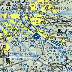
|
 Download PDF
of official airport diagram from the FAA
| Airport distance calculator |
|---|
|
|
| Sunrise and sunset |
|---|
|
Times for 13-May-2026
| | Local
(UTC-4) | | Zulu
(UTC) |
|---|
| Morning civil twilight | | 05:24 | | 09:24 |
| Sunrise | | 05:54 | | 09:54 |
| Sunset | | 20:13 | | 00:13 |
| Evening civil twilight | | 20:44 | | 00:44 |
|
| Current date and time |
|---|
| Zulu (UTC) | 14-May-2026 00:58:25 |
|---|
| Local (UTC-4) | 13-May-2026 20:58:25 |
|---|
|
| METAR |
|---|
| KCXY | 132356Z 28016G31KT 4SM VCTS -RA FEW050 BKN060 OVC110 15/09 A2980 RMK AO2 PK WND 28046/2342 WSHFT 2338 LTG DSNT SW-N RAB43 SLP093 VCTS OVHD MOV SE P0000 60001 T01500089 10217 20150 53017
|
KMDT
4nm E | 140007Z 28021G28KT 4SM TSRA SCT050 BKN065 OVC075 14/10 A2980 RMK AO2 PK WND 27028/0004 WSHFT 2347 LTG DSNT ALQDS RAB00 OCNL LTGICCCCG W AND N TS W MOV E P0003 T01440100
|
KMUI
18nm NE | 140044Z VRB05KT 6SM VCTS -RA SCT006 BKN047CB OVC075 15/14 A2976 RMK AO2A LTG DSNT NE-SE-SW RAB59GRB01E06 TSB2359E44 TS 6NE-SE-S MOV NE SLP079
|
KTHV
18nm S | 140053Z AUTO 13003KT 5SM VCTS RA BR OVC060 12/11 A2980 RMK AO2 PK WND 30035/0007 LTG DSNT NE-S RAB08 TSB04E32B33E48 SLP092 P0021 T01220106
|
|
| TAF |
|---|
KMDT
4nm E | 131754Z 1318/1418 21008KT P6SM BKN060 OVC100 FM140000 27007KT P6SM -SHRA BKN040 PROB30 1400/1402 4SM -TSRA BKN030CB FM140300 30006KT P6SM SCT040 FM141400 30010G20KT P6SM BKN030
|
KMUI
18nm NE | 132315Z 1323/1501 23009KT 9000 -RA OVC050 650809 QNH2970INS TEMPO 1400/1402 19010G25KT 8000 -TSRA BKN030CB BECMG 1401/1402 VRB06KT 8000 -SHRA BR BKN010 QNH2974INS TEMPO 1403/1406 4800 BR OVC004 BECMG 1405/1406 30006KT 9999 NSW SCT010 BKN060 QNH2975INS BECMG 1412/1413 33015G20KT 9999 OVC040 QNH2977INS TX21/1323Z TN09/1410Z
|
|
| NOTAMs |
|---|
NOTAMs are issued by the DoD/FAA and will open in a separate window not controlled by AirNav.
|
|


