FAA INFORMATION EFFECTIVE 27 NOVEMBER 2025
Location
| FAA Identifier: | MDT |
| Lat/Long: | 40-11-35.4900N 076-45-45.4290W
40-11.591500N 076-45.757150W
40.1931917,-76.7626192
(estimated) |
| Elevation: | 310 ft. / 94.5 m (surveyed) |
| Variation: | 11W (2005) |
| From city: | 8 miles SE of HARRISBURG, PA |
| Time zone: | UTC -5 (UTC -4 during Daylight Saving Time) |
| Zip code: | 17057 |
Airport Operations
| Airport use: | Open to the public |
| Activation date: | 07/1942 |
| Control tower: | yes |
| ARTCC: | NEW YORK CENTER |
| FSS: | WILLIAMSPORT FLIGHT SERVICE STATION |
| NOTAMs facility: | MDT (NOTAM-D service available) |
| Attendance: | CONTINUOUS |
| Pattern altitude: | TPA 1300 FT MSL (990 FT AGL) PROPS; 1800 FT MSL (1490 FT AGL) JETS. |
| Wind indicator: | lighted |
| Segmented circle: | no |
| Beacon: | white-green (lighted land airport)
Operates sunset to sunrise. |
| Landing fee: | yes |
| Fire and rescue: | ARFF index B |
| International operations: | customs landing rights airport |
Airport Communications
| ATIS: | 118.8 |
| WX ASOS: | PHONE 717-944-1372 |
| HARRISBURG INTL GROUND: | 121.7 348.6 |
| HARRISBURG INTL TOWER: | 124.8 269.35 |
| HARRISBURG APPROACH: | 118.25 ;330-079 124.1 ;180-329 126.45 ;080-179 269.45 ;330-079 273.525 ;180-329 281.525 ;080-179 |
| HARRISBURG DEPARTURE: | 118.25 ;330-079 124.1 ;180-329 126.45 ;080-179 269.45 ;330-079 273.525 ;180-329 281.525 ;080-179 |
| ANG OPS: | 395.1 |
| CLASS C: | 118.25 ;330-079 124.1 ;180-329 126.45 ;080-179 269.45 ;330-079 273.525 ;180-329 281.525 ;080-179 |
| EMERG: | 121.5 243.0 |
| VFR ADZY: | 124.8 |
| WX ASOS at CXY (4 nm W): | PHONE 717-770-0880 |
| WX ASOS at MUI (17 nm NE): | 124.175 (717-861-6493) |
| WX ASOS at THV (17 nm S): | 119.275 (717-792-5529) |
Nearby radio navigation aids
| VOR radial/distance | | VOR name | | Freq | | Var |
|---|
| HARr125/15.5 | | HARRISBURG VORTAC | | 115.35 | | 10W |
| LRPr290/22.1 | | LANCASTER VOR/DME | | 117.30 | | 09W |
| RAVr210/22.9 | | RAVINE VORTAC | | 114.60 | | 11W |
| SEGr179/36.3 | | SELINSGROVE VOR/DME | | 110.40 | | 08W |
| NDB name | | Hdg/Dist | | Freq | | Var | | ID |
|---|
| ENOLA | | 128/7.1 | | 204 | | 11W | | MD | -- -.. |
| BELLGROVE | | 223/17.4 | | 328 | | 10W | | BZJ | -... --.. .--- |
Airport Services
| Fuel available: | 100LL JET-A |
| Parking: | hangars and tiedowns |
| Airframe service: | MAJOR |
| Powerplant service: | MAJOR |
| Bottled oxygen: | LOW |
| Bulk oxygen: | HIGH/LOW |
Runway Information
Runway 13/31
| Dimensions: | 10001 x 200 ft. / 3048 x 61 m |
| Surface: | asphalt/grooved, in good condition |
| Weight bearing capacity: | | Single wheel: | 155.0 | | Double wheel: | 330.0 | | Double tandem: | 550.0 |
|
| Runway edge lights: | high intensity |
| RUNWAY 13 | | RUNWAY 31 |
| Latitude: | 40-11.962565N | | 40-11.220313N |
| Longitude: | 076-46.716013W | | 076-44.798453W |
| Elevation: | 310.0 ft. | | 309.7 ft. |
| Traffic pattern: | left | | right |
| Runway heading: | 128 magnetic, 117 true | | 308 magnetic, 297 true |
| Displaced threshold: | 993 ft. | | 993 ft. |
| Declared distances: | TORA:10001 TODA:10001 ASDA:9063 LDA:8070 | | TORA:10001 TODA:10001 ASDA:9122 LDA:8129 |
| Markings: | precision, in good condition | | precision, in good condition |
| Visual slope indicator: | 4-light PAPI on left (3.00 degrees glide path) | | 4-light PAPI on left (3.00 degrees glide path) |
| RVR equipment: | touchdown, midfield, rollout | | touchdown, midfield, rollout |
| Approach lights: | ALSF2: standard 2,400 foot high intensity approach lighting system with centerline sequenced flashers (category II or III) | | |
| Runway end identifier lights: | no | | yes |
| Centerline lights: | yes | | yes |
| Touchdown point: | yes, lighted | | yes, no lights |
| Instrument approach: | ILS | | ILS |
| Obstructions: | 60 ft. pole, 1780 ft. from runway, 719 ft. left of centerline, 26:1 slope to clear
APCH RATIO 47:1 TO DTHR. | | 78 ft. trees, 2485 ft. from runway, 712 ft. right of centerline, 29:1 slope to clear
RWY 31 APCH SLP 36:1 TO DTHR. |
Airport Ownership and Management from official FAA records
| Ownership: | Publicly-owned |
| Owner: | SUSQUEHANNA AREA REGIONAL ARPT AUTH
ONE TERMINAL DRIVE
MIDDLETOWN, PA 17057
Phone 717-948-3900 |
| Manager: | TIM EDWARDS
ONE TERMINAL DRIVE
MIDDLETOWN, PA 17057
Phone 717-948-3900 |
Additional Remarks
| A39-13/31 | PCR VALUE: 800/F/C/X/T |
| - | ACFT DESTINED FOR AVFLIGHT HARRISBURG SO INDICATE IN RMK SEC OF DD175 AND ATTEMPT TO CTC WITH ETA ON 122.95, 15 MIN PRIOR TO LND. |
| - | BIRD WATCH COND PHASE 1 (DEC-FEB & MAY-JUL) INDICATED LGT BIRD ACT. PHASE 2 (AUG-NOV & MAR-APR) INDICATES HVY BIRD ACT NML ASSOCIATED WITH MIGRATORY SEASON. |
| - | CARGO APRON PARKING SPOT 9 CLOSED TO ACFT WITH A WINGSPAN OF MORE THAN 52 FT. |
| - | COLD TEMPERATURE AIRPORT. ALTITUDE CORRECTION REQUIRED AT OR BELOW -16C. |
| - | USE CTN: DUE TO PROXIMITY & RWY ALMNT, AIRCREWS HAVE MISTAKEN CXY RWY 12/30 FOR MDT RWY 13/31 WHICH IS 4 NM E. |
| - | CARGO RAMP CLSD TO TSNT ACFT WO PRIOR PERMISSION; CALL AMGR 717-948-3919. |
| - | BIRD FLOCKS ON & INVOF ARPT. |
| - | NO TOUCH & GO LDGS 2300-0600 LCL. |
| - | REMARKS-ANG: ACFT NOT SUPPORTING ANG AND ALL FIGHTER ACFT MUST CTC FBO C 717-944-4666 FOR PRK AND FUEL. NSTD MRK ON C130J PRK APRON SPOT 5; WHITE PAINTED LINES DENOTING LAIRCM LASER TESTING AREA. |
Instrument Procedures
NOTE: All procedures below are presented as PDF files. If you need a reader for these files, you should download the free Adobe Reader.NOT FOR NAVIGATION. Please procure official charts for flight.
FAA instrument procedures published for use from 27 November 2025 at 0901Z to 25 December 2025 at 0900Z.
IAPs - Instrument Approach Procedures |
|---|
| ILS OR LOC RWY 13 | |
download (282KB) |
| ILS OR LOC RWY 31 | |
download (248KB) |
| ILS RWY 13 (SA CAT I) | |
download (266KB) |
| ILS RWY 13 (CAT II - III) | |
download (277KB) |
| RNAV (GPS) RWY 13 | |
download (261KB) |
| RNAV (GPS) RWY 31 | |
download (250KB) |
| VOR RWY 31 | |
download (229KB) |
| NOTE: Special Alternate Minimums apply | |
download (145KB) |
| NOTE: Special Take-Off Minimums/Departure Procedures apply | |
download (227KB) |
Other nearby airports with instrument procedures:
KCXY - Capital City Airport (4 nm W)
58N - Reigle Field Airport (10 nm NE)
N71 - Donegal Springs Airpark (11 nm SE)
KMUI - Muir (Fort Indiantown Gap) Army Heliport (17 nm NE)
KTHV - York Airport (17 nm S)
N94 - Carlisle Airport (19 nm W)
|
|

Road maps at:
MapQuest
Bing
Google
| Aerial photo |
|---|
WARNING: Photo may not be current or correct
 Photo by David Newcomer
Taken in November 2016
looking east
Photo by David Newcomer
Taken in November 2016
looking east
Do you have a better or more recent aerial photo of Harrisburg International Airport that you would like to share? If so, please send us your photo.
|
| Sectional chart |
|---|
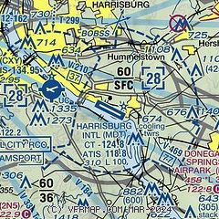
|
CAUTION: Diagram may not be current
 Download PDF
of official airport diagram from the FAA
| Airport distance calculator |
|---|
|
|
| Sunrise and sunset |
|---|
|
Times for 19-Dec-2025
| | Local
(UTC-5) | | Zulu
(UTC) |
|---|
| Morning civil twilight | | 06:55 | | 11:55 |
| Sunrise | | 07:26 | | 12:26 |
| Sunset | | 16:42 | | 21:42 |
| Evening civil twilight | | 17:13 | | 22:13 |
|
| Current date and time |
|---|
| Zulu (UTC) | 19-Dec-2025 12:03:21 |
|---|
| Local (UTC-5) | 19-Dec-2025 07:03:21 |
|---|
|
| METAR |
|---|
| KMDT | 191156Z 27018G40KT 2SM R13/4500VP6000FT +RA BR BKN014 OVC023 13/11 A2940 RMK AO2 PK WND 27040/1153 WSHFT 1141 PRESRR SLP958 P0001 60022 70060 T01280106 10139 20056 56047
|
KCXY
4nm W | 191158Z 25014G24KT 6SM -RA BR SCT014 BKN032 OVC044 13/11 A2940 RMK AO2 WSHFT 1143 P0000 T01280111
|
KMUI
16nm NE | 191141Z 16015G24KT 10SM VCSH BKN006 OVC011 15/14 A2935 RMK AO2A RAE41 PRESFR SLP942
|
KTHV
17nm S | 191158Z AUTO 26008G27KT 3SM -RA BR SCT014 BKN026 OVC050 12/10 A2941 RMK AO2 P0001 T01170100
|
|
| TAF |
|---|
| KMDT | 191132Z 1912/2012 16018G29KT P6SM -RA OVC012 WS020/17050KT FM191500 28021G32KT P6SM -RA OVC025 FM191900 29022G38KT P6SM BKN035 FM200500 30021G29KT P6SM SCT250 FM201000 30008KT P6SM FEW250
|
KMUI
16nm NE | 191100Z 1911/2017 18009KT 9000 -RA OVC006 520009 520909 QNH2941INS BECMG 1912/1913 28025G45KT 9999 NSW BKN010 OVC040 520009 QNH2938INS BECMG 1914/1915 28015G35KT 9999 -RA BKN020 OVC045 620309 520009 QNH2952INS BECMG 2006/2007 30010G25KT 9999 NSW BKN050 520109 QNH2998INS BECMG 2010/2011 24010G15KT 9999 SCT030 520109 QNH3010INS TX13/1912Z TNM02/2003Z
|
|
| NOTAMs |
|---|
NOTAMs are issued by the DoD/FAA and will open in a separate window not controlled by AirNav.
|
|


