FAA INFORMATION EFFECTIVE 27 NOVEMBER 2025
Location
| FAA Identifier: | THV |
| Lat/Long: | 39-55-01.2000N 076-52-22.9000W
39-55.020000N 076-52.381667W
39.9170000,-76.8730278
(estimated) |
| Elevation: | 494.7 ft. / 150.8 m (surveyed) |
| Variation: | 11W (2000) |
| From city: | 7 miles SW of YORK, PA |
| Time zone: | UTC -5 (UTC -4 during Daylight Saving Time) |
| Zip code: | 17364 |
Airport Operations
| Airport use: | Open to the public |
| Activation date: | 12/1940 |
| Control tower: | no |
| ARTCC: | NEW YORK CENTER |
| FSS: | WILLIAMSPORT FLIGHT SERVICE STATION |
| NOTAMs facility: | THV (NOTAM-D service available) |
| Attendance: | MON-FRI 0600-1800, ALL SAT-SUN 0800-1700 |
| Wind indicator: | lighted |
| Segmented circle: | no |
| Lights: | SS-SR |
| Beacon: | white-green (lighted land airport)
Operates sunset to sunrise. |
| Landing fee: | yes |
Airport Communications
| CTAF/UNICOM: | 123.0 |
| WX ASOS: | 119.275 (717-792-5529) |
| HARRISBURG APPROACH: | 124.1 |
| HARRISBURG DEPARTURE: | 124.1 |
| CLEARANCE DELIVERY: | 121.65 |
| WX ASOS at MDT (17 nm N): | PHONE 717-944-1372 |
| WX ASOS at CXY (18 nm N): | PHONE 717-770-0880 |
| WX AWOS-3 at DMW (20 nm S): | 121.25 (410-876-1281) |
Nearby radio navigation aids
| VOR radial/distance | | VOR name | | Freq | | Var |
|---|
| HARr169/24.8 | | HARRISBURG VORTAC | | 115.35 | | 10W |
| EMIr019/25.8 | | WESTMINSTER VORTAC | | 117.90 | | 08W |
| LRPr255/29.4 | | LANCASTER VOR/DME | | 117.30 | | 09W |
| FDKr045/38.1 | | FREDERICK VOR/DME | | 116.85 | | 08W |
| NDB name | | Hdg/Dist | | Freq | | Var | | ID |
|---|
| BELLGROVE | | 215/34.4 | | 328 | | 10W | | BZJ | -... --.. .--- |
| ELLICOTT | | 004/38.0 | | 371 | | 11W | | FND | ..-. -. -.. |
Airport Services
| Fuel available: | 100LL JET-A |
| Parking: | hangars and tiedowns |
| Airframe service: | MAJOR |
| Powerplant service: | MAJOR |
| Bottled oxygen: | HIGH |
| Bulk oxygen: | NONE |
Runway Information
Runway 17/35
| Dimensions: | 5188 x 100 ft. / 1581 x 30 m |
| Surface: | asphalt/grooved, in good condition |
| Weight bearing capacity: | | Single wheel: | 20.0 | | Double wheel: | 20.0 | | Double tandem: | 20.0 |
|
| Runway edge lights: | medium intensity |
| RUNWAY 17 | | RUNWAY 35 |
| Latitude: | 39-55.408087N | | 39-54.631482N |
| Longitude: | 076-52.612953W | | 076-52.150000W |
| Elevation: | 475.8 ft. | | 494.7 ft. |
| Traffic pattern: | left | | left |
| Runway heading: | 166 magnetic, 155 true | | 346 magnetic, 335 true |
| Displaced threshold: | 794 ft. | | 739 ft. |
| Markings: | nonprecision, in good condition | | nonprecision, in good condition |
| Visual slope indicator: | 4-light PAPI on left (4.50 degrees glide path) | | 4-light PAPI on left (3.67 degrees glide path) |
| Runway end identifier lights: | yes | | yes |
| Touchdown point: | yes, no lights | | yes, no lights |
| Obstructions: | 40 ft. pole, lighted, 226 ft. from runway, 183 ft. right of centerline
RWY 17 HAS +15 FT ROAD 10-200 FT FROM RWY END 250 FT LEFT & RIGHT; +15 BLAST FENCE 50-85 FT FROM RWY END MARKED AND LIGHTED. | | 44 ft. trees, lighted, 404 ft. from runway, 223 ft. left of centerline, 4:1 slope to clear |
Airport Ownership and Management from official FAA records
| Ownership: | Privately-owned |
| Owner: | YORK BLDG PRODUCTS INC
PO BOX 2587
YORK, PA 17405
Phone 717-792-5566 |
| Manager: | MARK TOMLINSON
6054 LINCOLN HIGHWAY WEST
THOMASVILLE, PA 17364
Phone 717-792-5566 |
Additional Remarks
| - | TREES WI PRIM SFC 83 FT IN FM THLD & 221 FT L OF RWY 17 CNTRLN; RAMP TIE-DOWN AREA, MEDIVAC PARKING PAD & TWY WI PRIM SFC ON R SIDE. |
| - | TWY TO RWY 35 CLSD TO ACFT WITH WINGSPAN OVER 60 FT. |
| - | RWY 17 TREES 1383 FT OUT 121 FT RIGHT APCH SLP 21:1 TO DTHR. |
| - | RWY 35 TREES 2684 FT OUT 425 FT RIGHT APCH SLP 22:1 TO DTHR. |
| - | FOR CD CTC HARRISBURG APCH AT 800-932-0712. |
Instrument Procedures
NOTE: All procedures below are presented as PDF files. If you need a reader for these files, you should download the free Adobe Reader.NOT FOR NAVIGATION. Please procure official charts for flight.
FAA instrument procedures published for use from 27 November 2025 at 0901Z to 25 December 2025 at 0900Z.
IAPs - Instrument Approach Procedures |
|---|
| RNAV (GPS) RWY 17 | |
download (212KB) |
| RNAV (GPS) RWY 35 | |
download (214KB) |
| NOTE: Special Alternate Minimums apply | |
download (145KB) |
| NOTE: Special Take-Off Minimums/Departure Procedures apply | |
download (149KB) |
Other nearby airports with instrument procedures:
N71 - Donegal Springs Airpark (17 nm NE)
KMDT - Harrisburg International Airport (17 nm N)
KCXY - Capital City Airport (18 nm N)
W05 - Gettysburg Regional Airport (19 nm W)
KDMW - Carroll County Regional Airport/Jack B Poage Field (20 nm S)
|
|

Road maps at:
MapQuest
Bing
Google
| Aerial photo |
|---|
WARNING: Photo may not be current or correct
 Photo taken 01-Jun-2019
looking northeast.
Photo taken 01-Jun-2019
looking northeast.
Do you have a better or more recent aerial photo of York Airport that you would like to share? If so, please send us your photo.
|
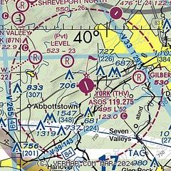
| Sectional chart |
|---|
|
 Download PDF
of official airport diagram from the FAA
| Airport distance calculator |
|---|
|
|
| Sunrise and sunset |
|---|
|
Times for 13-Dec-2025
| | Local
(UTC-5) | | Zulu
(UTC) |
|---|
| Morning civil twilight | | 06:51 | | 11:51 |
| Sunrise | | 07:22 | | 12:22 |
| Sunset | | 16:42 | | 21:42 |
| Evening civil twilight | | 17:12 | | 22:12 |
|
| Current date and time |
|---|
| Zulu (UTC) | 13-Dec-2025 14:48:16 |
|---|
| Local (UTC-5) | 13-Dec-2025 09:48:16 |
|---|
|
| METAR |
|---|
| KTHV | 131353Z AUTO 00000KT 9SM CLR M03/M07 A3007 RMK AO2 SLP193 T10331067
|
KMDT
18nm N | 131356Z 13003KT 10SM OVC040 M03/M07 A3008 RMK AO2 SLP192 T10331067
|
KCXY
18nm N | 131356Z 10004KT 10SM OVC039 M03/M07 A3008 RMK AO2 SLP193 T10331072
|
KDMW
20nm S | 131435Z AUTO 21004KT 10SM CLR 01/M04 A3007 RMK AO2
|
|
| TAF |
|---|
KMDT
18nm N | 131120Z 1312/1412 14003KT P6SM OVC040 FM131400 23006KT P6SM OVC050 FM132100 27006KT P6SM OVC040 FM140000 30003KT 1SM -SN BKN015 OVC025 FM140800 32010G16KT P6SM SCT050
|
|
| NOTAMs |
|---|
NOTAMs are issued by the DoD/FAA and will open in a separate window not controlled by AirNav.
|
|


