FAA INFORMATION EFFECTIVE 14 MAY 2026
Location
| FAA Identifier: | E68 |
| Lat/Long: | 33-05-07.1760N 112-09-39.5260W
33-05.119600N 112-09.658767W
33.0853267,-112.1609794
(estimated) |
| Elevation: | 1273 ft. / 388 m (estimated) |
| Variation: | 13E (1985) |
| From city: | 6 miles W of MARICOPA, AZ |
| Time zone: | UTC -7 (year round; does not observe DST) |
| Zip code: | 85239 |
Gliderport Operations
| Gliderport use: | Open to the public |
| Activation date: | 03/1969 |
| Control tower: | no |
| ARTCC: | ALBUQUERQUE CENTER |
| FSS: | PRESCOTT FLIGHT SERVICE STATION |
| NOTAMs facility: | PRC (NOTAM-D service available) |
| Attendance: | 0900-1700 |
| Wind indicator: | yes |
| Segmented circle: | yes |
Gliderport Communications
| CTAF: | 122.9 |
| WX AWOS-3 at A39 (13 nm SE): | 126.900 (520-568-7704) |
Nearby radio navigation aids
| VOR radial/distance | | VOR name | | Freq | | Var |
|---|
| TFDr301/17.4 | | STANFIELD VORTAC | | 114.80 | | 12E |
| PXRr193/23.0 | | PHOENIX VORTAC | | 115.60 | | 12E |
| GBNr059/27.0 | | GILA BEND VORTAC | | 116.60 | | 14E |
| IWAr230/28.7 | | WILLIE VORTAC | | 113.30 | | 13E |
| BXKr110/40.0 | | BUCKEYE VORTAC | | 110.60 | | 14E |
Gliderport Services
| Oil available: | 123.3 AVBL FOR COMM BTN GLIDER & TOW ACFT. |
| Parking: | tiedowns |
Runway Information
Runway 6R/24L
| Dimensions: | 2520 x 30 ft. / 768 x 9 m |
| Surface: | asphalt, in fair condition |
| RUNWAY 6R | | RUNWAY 24L |
| Latitude: | 33-05.049333N | | 33-05.163833N |
| Longitude: | 112-09.927667W | | 112-09.453000W |
| Traffic pattern: | right | | left |
| Runway end identifier lights: | no | | no |
Runway 7/25
| Dimensions: | 3740 x 20 ft. / 1140 x 6 m |
| Surface: | dirt, in fair condition |
| RUNWAY 7 | | RUNWAY 25 |
| Traffic pattern: | left | | left |
| Obstructions: | 10 ft. brush, 256 ft. from runway, 70 ft. right of centerline, 25:1 slope to clear | | 6 ft. brush, 105 ft. from runway, 55 ft. left of centerline, 17:1 slope to clear |
Runway 6C/24C
| Dimensions: | 1995 x 25 ft. / 608 x 8 m |
| Surface: | dirt, in fair condition |
| RUNWAY 6C | | RUNWAY 24C |
| Traffic pattern: | right | | left |
| Markings: | none | | none |
| Runway end identifier lights: | no | | no |
| Obstructions: | 4 ft. brush, 20 ft. from runway, 60 ft. left of centerline, 5:1 slope to clear | | 8 ft. brush, 100 ft. from runway, 75 ft. right of centerline, 12:1 slope to clear |
Runway 6L/24R
| Dimensions: | 1910 x 25 ft. / 582 x 8 m |
| Surface: | dirt, in fair condition |
| RUNWAY 6L | | RUNWAY 24R |
| Traffic pattern: | right | | left |
| Markings: | none | | none |
| Runway end identifier lights: | no | | no |
| Obstructions: | 10 ft. tree, 90 ft. from runway, 30 ft. right of centerline, 9:1 slope to clear | | none |
Gliderport Ownership and Management from official FAA records
| Ownership: | Privately-owned |
| Owner: | ARIZONA SOARING INC
PO BOX 858
MARICOPA, AZ 85139
Phone 520-568-2318 |
| Manager: | JASON STEPHENS
PO BOX 858
MARICOPA, AZ 85239
Phone 520-568-2318 |
Additional Remarks
| A58-06R | 4 FT BRUSH 117 FT L AT RWY END. |
| A58-24L | 5 FT BRUSH 40 FT L & 0-20 FT RWY END. |
| A30A-07 | CLSD INDEFLY. |
| - | OBSTRNS MTNS SW, N & NW. 1 FT BERM & 1 FT DITCH 30 FT NORTH OF RWY 06L/24R. |
| - | ARPT CLSD AT NIGHT. |
| - | FOR CD CTC PHOENIX APCH AT 602-306-2565. |
| - | GLIDERS NOT EQUIPPED WITH ADS-B |
| - | PWR ACFT PAT S OF RWYS; GLIDER PAT N OF RWYS. |
| - | PWR OPS USE RWY NOT IN USE BY GLIDERS. |
| - | AEROBATIC BOX ACTV 0900-1800; ONE SQUARE MI ARND PXR194023. |
| - | HVY NO RADIO ACT. |
| - | TKOFF PAVED RWY ONLY. |
| - | ALERT: HVY GLIDER TFC OPS WO COM WI 5 NM. |
| - | ALL OPS PPR DUE TO GLIDER ACT - AMGR. |
Instrument Procedures
There are no published instrument procedures at E68.
Some nearby airports with instrument procedures:
P19 - Stellar Airpark (18 nm NE)
KCHD - Chandler Municipal Airport (21 nm NE)
KCGZ - Casa Grande Municipal Airport (21 nm E)
KPHX - Phoenix Sky Harbor International Airport (22 nm N)
KGYR - Phoenix Goodyear Airport (23 nm NW)
|
|

Road maps at:
MapQuest
Bing
Google
| Aerial photo |
|---|
WARNING: Photo may not be current or correct

Do you have a better or more recent aerial photo of Estrella Sailport that you would like to share? If so, please send us your photo.
|
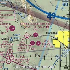
| Sectional chart |
|---|
|
| Airport distance calculator |
|---|
|
|
| Sunrise and sunset |
|---|
|
Times for 10-Jun-2026
| | Local
(UTC-7) | | Zulu
(UTC) |
|---|
| Morning civil twilight | | 04:52 | | 11:52 |
| Sunrise | | 05:20 | | 12:20 |
| Sunset | | 19:36 | | 02:36 |
| Evening civil twilight | | 20:05 | | 03:05 |
|
| Current date and time |
|---|
| Zulu (UTC) | 10-Jun-2026 23:04:04 |
|---|
| Local (UTC-7) | 10-Jun-2026 16:04:04 |
|---|
|
| METAR |
|---|
KA39
13nm SE | 102230Z AUTO 31012G15KT 270V330 10SM CLR 40/M04 A2977 RMK AO2
|
KCHD
20nm NE | 102247Z 24011KT 10SM CLR 40/M02 A2973
|
KCGZ
21nm E | 102256Z AUTO 29010G16KT 10SM CLR 41/M05 A2974 RMK AO2 SLP053 T04061050 $
|
KPHX
22nm N | 102251Z 28010G17KT 10SM CLR 41/M04 A2970 RMK AO2 SLP034 T04061044
|
KGYR
22nm NW | 102247Z 25012G15KT 10SM SKC 40/01 A2972
|
|
| TAF |
|---|
KPHX
22nm N | 102048Z 1021/1124 27010KT P6SM SKC FM111100 09005KT P6SM FEW250 FM112000 26008KT P6SM FEW250
|
|
| NOTAMs |
|---|
NOTAMs are issued by the DoD/FAA and will open in a separate window not controlled by AirNav.
|
|

