FAA INFORMATION EFFECTIVE 14 MAY 2026
Location
| FAA Identifier: | PHX |
| Lat/Long: | 33-26-03.4000N 112-00-41.7000W
33-26.056667N 112-00.695000W
33.4342778,-112.0115833
(estimated) |
| Elevation: | 1134.8 ft. / 345.9 m (surveyed) |
| Variation: | 12E (2000) |
| From city: | 3 miles E of PHOENIX, AZ |
| Time zone: | UTC -7 (year round; does not observe DST) |
| Zip code: | 85034 |
Airport Operations
| Airport use: | Open to the public |
| Activation date: | 04/1940 |
| Control tower: | yes |
| ARTCC: | ALBUQUERQUE CENTER |
| FSS: | PRESCOTT FLIGHT SERVICE STATION |
| NOTAMs facility: | PHX (NOTAM-D service available) |
| Attendance: | CONTINUOUS |
| Pattern altitude: | TPA: 1000 FT AGL LGT ACFT & NON-TURBOJETS; 1500 FT AGL HVY ACFT & TURBOJETS. |
| Wind indicator: | lighted |
| Segmented circle: | no |
| Beacon: | white-green (lighted land airport)
Operates sunset to sunrise. |
| Landing fee: | yes, OVNGT PRKG FEE. |
| Fire and rescue: | ARFF index E |
| International operations: | customs landing rights airport |
Airport Communications
| WX ASOS: | PHONE 602-551-6092 |
| PHOENIX GROUND: | 119.75 ;NORTH 132.55 ;SOUTH 269.2 |
| PHOENIX TOWER: | 118.7 ;RWY 08/26 120.9 ;RWY 07L/25R, 07R/25L 254.3 ;RWY 07L/25R, 07R/25L 278.8 ;RWY 08/26 |
| PHOENIX APPROACH: | 119.2 ;319-057 7500 FT & ABV 120.7 ;319-057 BLW 7500 FT 123.7 ;119-138 BLW 7500 FT 123.7 ;139-191 BLW 8500 FT 124.1 ;119-138 7500-14500 FT 124.1 ;192-263 7500-12500 FT 124.9 ;058-118 BLW 10500 FT 126.8 ;058-118 10500 FT & ABV 126.8 ;119-138 ABV 14500 FT 126.8 ;139-191 8500 FT & ABV 126.8 ;192-263 ABV 12500 FT 128.65 ;340-079 ABV 5500 FT |
| PHOENIX DEPARTURE: | 119.2 ;319-057 7500 FT & ABV 120.7 ;319-057 BLW 7500 FT 123.7 ;119-138 BLW 7500 FT 123.7 ;139-191 BLW 8500 FT 124.1 ;119-138 7500-14500 FT 124.1 ;192-263 7500-12500 FT 124.9 ;058-118 BLW 10500 FT 126.8 ;058-118 10500 FT & ABV 126.8 ;119-138 ABV 14500 FT 126.8 ;139-191 8500 FT & ABV 126.8 ;192-263 ABV 12500 FT 128.65 ;340-079 ABV 5500 FT |
| CLEARANCE DELIVERY: | 118.1 269.2 |
| BALDY DP: | 126.8 |
| BLYTHE STAR: | 124.1 |
| BROAK DP: | 126.8 |
| BRUSR STAR: | 128.65 |
| BUCKEYE DP: | 126.8 |
| BUNTR STAR: | 128.65 |
| CHILY DP: | 119.2 |
| CLASS B: | 119.2 ;319-057 7500 FT & ABV 120.7 ;319-057 BLW 7500 FT 123.7 ;119-138 BLW 7500 FT 123.7 ;139-191 BLW 8500 FT 124.1 ;119-138 7500-14500 FT 124.1 ;192-263 7500-12500 FT 124.9 ;058-118 BLW 10500 FT 126.8 ;058-118 10500 FT & ABV 126.8 ;119-138 ABV 14500 FT 126.8 ;139-191 8500 FT & ABV 126.8 ;192-263 ABV 12500 FT |
| COYOT STAR: | 128.65 |
| D-ATIS: | 127.575 |
| DSERT STAR: | 120.7 |
| EAGUL STAR: | 128.65 |
| ECLPS DP: | 126.8 |
| EMERG: | 243.0 |
| FORPE DP: | 119.2 |
| FYRBD DP: | 126.8 |
| HYDRR STAR: | 124.1 |
| IC: | 128.65 ;340-079 ABV 5500 FT |
| JESSE STAR: | 128.65 |
| KEENS DP: | 126.8 |
| MOBIE DP: | 126.8 |
| MRBIL DP: | 119.2 |
| QUAKY DP: | 119.2 |
| ST. JOHNS DP: | 119.2 |
| STANFIELD DP: | 126.8 |
| STRRM DP: | 126.8 |
| SUNSS STAR: | 124.1 |
| WETAL DP: | 126.8 |
| ZEPER DP: | 119.2 |
| ZIDOG DP: | 119.2 |
| WX ASOS at SDL (12 nm NE): | PHONE 480-483-3049 |
| WX AWOS-3PT at CHD (14 nm SE): | PHONE 480-814-9952 |
| WX ASOS at FFZ (14 nm E): | PHONE 480-641-4111 |
| WX AWOS-3 at GEU (15 nm W): | PHONE 623-877-8609 |
| WX ASOS at DVT (16 nm N): | 126.5 (480-308-1230) |
| WX AWOS-3 at IWA (19 nm SE): | 133.5 (480-988-9428) |
- ASDE-X IN USE. OPERATE TRANSPONDERS WITH ALTITUDE REPORTING MODE AND ADS-B (IF EQUIPPED) ENABLED ON ALL AIRPORT SURFACES.
- OPS 1200-0100Z MON-THU; 1200-2200Z FRI, 48 HR PPR. CLSD WKEND, HOL. AMOPS D853-9162/C602-302-9162. 24 HR CP D853-9071. BIRDS INVOF; BASH PHASE I JAN-FEB & JUN-SEP MIG SEASON INCREASED BIRD ACTV. PHASE II HVY BIRD ACT. BWC UPON REQUEST. SEE AP1.
Nearby radio navigation aids
| VOR radial/distance | | VOR name | | Freq | | Var |
|---|
| PXRr260/2.1 | | PHOENIX VORTAC | | 115.60 | | 12E |
| IWAr281/19.7 | | WILLIE VORTAC | | 113.30 | | 13E |
| TFDr339/33.3 | | STANFIELD VORTAC | | 114.80 | | 12E |
Airport Services
| Fuel available: | 100LL JET-A |
| Parking: | hangars and tiedowns |
| Airframe service: | MAJOR |
| Powerplant service: | MAJOR |
| Bottled oxygen: | HIGH/LOW |
| Bulk oxygen: | HIGH/LOW |
Runway Information
Runway 8/26
| Dimensions: | 11489 x 150 ft. / 3502 x 46 m |
| Surface: | concrete/grooved, in good condition |
| Weight bearing capacity: | | Single wheel: | 30.0 | | Double wheel: | 200.0 | | Double tandem: | 455.0 | | Dual double tandem: | 965.0 |
|
| Runway edge lights: | high intensity |
| RUNWAY 8 | | RUNWAY 26 |
| Latitude: | 33-26.451655N | | 33-26.449405N |
| Longitude: | 112-01.787617W | | 111-59.528140W |
| Elevation: | 1111.1 ft. | | 1134.7 ft. |
| Traffic pattern: | left | | right |
| Runway heading: | 078 magnetic, 090 true | | 258 magnetic, 270 true |
| Displaced threshold: | 898 ft. | | no |
| Declared distances: | TORA:11489 TODA:11489 ASDA:11489 LDA:10591 | | TORA:11489 TODA:11489 ASDA:11489 LDA:11489 |
| Markings: | precision, in good condition | | precision, in good condition |
| Visual slope indicator: | 4-light PAPI on left (3.00 degrees glide path) | | 4-light PAPI on left (3.00 degrees glide path) |
| Approach lights: | MALSF: 1,400 foot medium intensity approach lighting system with sequenced flashers | | |
| Runway end identifier lights: | no | | yes |
| Touchdown point: | yes, no lights | | yes, no lights |
| Instrument approach: | ILS/DME | | ILS/DME |
| Obstructions: | 66 ft. bldg, 3020 ft. from runway, 503 ft. left of centerline, 42:1 slope to clear | | 9 ft. road, 905 ft. from runway, 540 ft. right of centerline |
Runway 7L/25R
| Dimensions: | 10300 x 150 ft. / 3139 x 46 m |
| Surface: | concrete/grooved, in good condition |
| Weight bearing capacity: | | Single wheel: | 30.0 | | Double wheel: | 235.0 | | Double tandem: | 435.0 | | Dual double tandem: | 940.0 |
|
| Runway edge lights: | high intensity |
| RUNWAY 7L | | RUNWAY 25R |
| Latitude: | 33-25.863468N | | 33-25.862140N |
| Longitude: | 112-01.626098W | | 111-59.600715W |
| Elevation: | 1110.2 ft. | | 1134.0 ft. |
| Traffic pattern: | right | | left |
| Runway heading: | 078 magnetic, 090 true | | 258 magnetic, 270 true |
| Declared distances: | TORA:10300 TODA:10300 ASDA:10300 LDA:10300 | | TORA:10300 TODA:10300 ASDA:10300 LDA:10300 |
| Markings: | precision, in good condition | | precision, in good condition |
| Visual slope indicator: | 4-light PAPI on left (3.00 degrees glide path) | | 4-light PAPI on left (3.00 degrees glide path) |
| RVR equipment: | touchdown | | rollout |
| Approach lights: | MALSR: 1,400 foot medium intensity approach lighting system with runway alignment indicator lights | | |
| Runway end identifier lights: | no | | no |
| Touchdown point: | yes, no lights | | yes, no lights |
| Instrument approach: | ILS/DME | | |
| Obstructions: | 62 ft. pole, 2958 ft. from runway, 750 ft. right of centerline, 44:1 slope to clear | | 416 ft. ant, marked and lighted, 17582 ft. from runway, 600 ft. left of centerline, 41:1 slope to clear |
Runway 7R/25L
| Dimensions: | 7800 x 150 ft. / 2377 x 46 m |
| Surface: | concrete/grooved, in good condition |
| Weight bearing capacity: | | Single wheel: | 30.0 | | Double wheel: | 200.0 | | Double tandem: | 400.0 | | Dual double tandem: | 1010.0 |
|
| Runway edge lights: | high intensity |
| RUNWAY 7R | | RUNWAY 25L |
| Latitude: | 33-25.731538N | | 33-25.730590N |
| Longitude: | 112-01.626143W | | 112-00.092353W |
| Elevation: | 1111.0 ft. | | 1126.3 ft. |
| Traffic pattern: | left | | left |
| Runway heading: | 078 magnetic, 090 true | | 258 magnetic, 270 true |
| Declared distances: | TORA:7800 TODA:7800 ASDA:7800 LDA:7800 | | TORA:7800 TODA:7800 ASDA:7800 LDA:7800 |
| Markings: | precision, in good condition | | precision, in good condition |
| Visual slope indicator: | 4-light PAPI on left (3.00 degrees glide path) | | 4-light PAPI on left (3.00 degrees glide path) |
| Approach lights: | MALSR: 1,400 foot medium intensity approach lighting system with runway alignment indicator lights | | MALSR: 1,400 foot medium intensity approach lighting system with runway alignment indicator lights |
| Touchdown point: | yes, no lights | | yes, no lights |
| Instrument approach: | ILS/DME | | ILS/DME |
| Obstructions: | 33 ft. pole, lighted, 900 ft. from runway, 640 ft. right of centerline, 20:1 slope to clear | | 424 ft. ant, marked and lighted, 20059 ft. from runway, 1193 ft. left of centerline, 46:1 slope to clear |
Airport Ownership and Management from official FAA records
| Ownership: | Publicly-owned |
| Owner: | CITY OF PHOENIX
2485 E BUCKEYE RD
PHOENIX, AZ 85034
Phone 602-273-3302 |
| Manager: | CHAD MAKOVSKY
2485 E BUCKEYE RD
PHOENIX, AZ 85034
Phone 602-273-3302
24 HR DUTY MGR 602-273-3388; AIRSIDE OPS OFC 602-273-2008; OPS SUPT 602-273-2072. |
Additional Remarks
| A39-07R/25L | PCR VALUE: 796/R/A/W/T |
| A39-07L/25R | PCR VALUE: 674/R/A/W/T |
| A39-08/26 | PCR VALUE: 846/R/A/W/T |
| A105 | LTD TSNT MAINT & PRK; PPR - COPPER CONTROL 30 MIN BFR ARR OR DEP - 311.0. WHEN ANG CLSD TSNT - 602-273-3770 OR 132.0. |
| - | NOISE ABATEMENT PROC IN EFCT. |
| - | TWY R & PTNS OF TWY S & T BLW ATCT NOT VSB FM ATCT. |
| - | TWY R OVHD TRAIN BRIDGE AT MIDPT PRVDS 81 FT 9 IN CLNC. TXL Y3 OVHD TRAIN BRIDGE AT MIDPT PRVDS 44 FT 7 IN CLNC. |
| - | EXPERIMENTAL OR GND DMSTN NA WO PRIOR APVL - AIRSIDE OPS. |
| - | ANG: OFFL BUS ONLY; BASH PHASE II IN EFCT 1 MAR - 31 MAY & 1 AUG - 31 OCT; LTD RAMP SPACE AVBL - 602-273-3770. |
| - | PPR WINGSPAN 215 FT OR GTR GROUP VI - OPS 602-273-2008 FOR FOLLOW ME SVC WHILE TAX TO & FM RAMP & RWYS. |
| - | PRAC INST APCH, STOP & TAX BACK LDG, STOP & GO LDG, TGL NA. OTR FLIGHT TRNG OPS NA WO PRIOR WRITTEN APVL - AIRSIDE OPS 602-273-2008. |
| - | ENG RUNS NA WO PRIOR COORD WITH AIRSIDE OPS. |
| - | INTL GATE USE RQR CDN WITH ARPT OPS 48 HR PRIOR TO ARR. |
| - | INTL LDG RIGHTS RQR US CUST & BDR PROTECTION NOTIFICATION 48 HR PRIOR TO LDG. |
| - | REVIEW HOT SPOT INFO ON ARPT DIAGRAM. |
| - | RWY STATUS LGTS IN OPRN. |
| - | GEN INFO - 602-273-3302. |
| - | FEE FOR CHARTERS, TRAVEL CLUB & REVENUE PRODUCING ACFT. |
| - | TWYS A BTN A3 AND A10, A4, A5, A6, A7, A8, A9 CLSD TO ACFT WINGSPAN OF MORE THAN 125FT. |
| - | TWY A BTN INT A11 & A12, A12, D BTN INT D13 TO R, D13, F BTW INT G2 & G3 CLSD TO WINGSPAN GTR THAN 135 FT. |
| - | TWY C BTN TXL I & C9, BTN C9 & C10, BTN C10 & C11, BTN C11 & Q, TWY D BTN D8 & T, D9, TWY H BTN TWY H4 & H7, H5, H6, H7 CLSD TO WINGSPAN GTR THAN 171 FT. |
| - | TWY D BTN S & D13, D10, D11, D12 CLSD TO WINGSPAN GTR THAN 118 FT. |
Instrument Procedures
NOTE: All procedures below are presented as PDF files. If you need a reader for these files, you should download the free Adobe Reader.NOT FOR NAVIGATION. Please procure official charts for flight.
FAA instrument procedures published for use from 14 May 2026 at 0901Z to 11 June 2026 at 0900Z.
STARs - Standard Terminal Arrivals |
|---|
| ARLIN FOUR | |
download (286KB) |
| BLYTHE FIVE | |
download (255KB) |
| BRUSR ONE (RNAV) | |
2 pages:
[1] [2] (351KB) |
| BRUSR ONE (RNAV), CONT.2 | |
download (365KB) |
| BUNTR THREE | |
2 pages:
[1] [2] (316KB) |
| COYOT FIVE | |
2 pages:
[1] [2] (347KB) |
| DSERT TWO (RNAV) | |
2 pages:
[1] [2] (312KB) |
| EAGUL SIX (RNAV) | |
2 pages:
[1] [2] (388KB) |
| EAGUL SIX (RNAV), CONT.2 | |
download (392KB) |
| HYDRR ONE (RNAV) | |
2 pages:
[1] [2] (344KB) |
| HYDRR ONE (RNAV), CONT.2 | |
download (387KB) |
| JESSE THREE | |
download (228KB) |
| PINNG ONE (RNAV) | |
2 pages:
[1] [2] (308KB) |
| PINNG ONE (RNAV), CONT.2 | |
download (388KB) |
| SUNSS EIGHT | |
download (237KB) |
IAPs - Instrument Approach Procedures |
|---|
| ILS OR LOC RWY 07R | |
download (309KB) |
| ILS OR LOC RWY 08 | |
download (292KB) |
| ILS OR LOC RWY 25L | |
download (290KB) |
| ILS OR LOC RWY 26 | |
download (288KB) |
| ILS OR LOC/DME RWY 07L | |
download (235KB) |
| RNAV (GPS) Y RWY 07L | |
download (260KB) |
| RNAV (GPS) Y RWY 07R | |
download (271KB) |
| RNAV (GPS) Y RWY 08 | |
download (252KB) |
| RNAV (GPS) Y RWY 25L | |
download (259KB) |
| RNAV (GPS) Y RWY 25R | |
download (257KB) |
| RNAV (GPS) Y RWY 26 | |
download (233KB) |
| NOTE: Special Alternate Minimums apply | |
download (141KB) |
Departure Procedures |
|---|
| BALDY THREE | |
2 pages:
[1] [2] (469KB) |
| BROAK ONE (RNAV) | |
download (310KB) |
| BUCKEYE FOUR | |
2 pages:
[1] [2] (508KB) |
| CHILY FOUR | |
2 pages:
[1] [2] (466KB) |
| ECLPS ONE (RNAV) | |
download (240KB) |
| FORPE ONE (RNAV) | |
2 pages:
[1] [2] (471KB) |
| FYRBD ONE (RNAV) | |
download (243KB) |
| KEENS THREE (RNAV) | |
download (290KB) |
| MOBIE FOUR | |
download (309KB) |
| MRBIL ONE (RNAV) | |
2 pages:
[1] [2] (438KB) |
| QUAKY ONE (RNAV) | |
2 pages:
[1] [2] (492KB) |
| ST. JOHNS NINE | |
2 pages:
[1] [2] (436KB) |
| STANFIELD FOUR | |
download (294KB) |
| STRRM ONE (RNAV) | |
2 pages:
[1] [2] (300KB) |
| ZEPER TWO (RNAV) | |
2 pages:
[1] [2] (364KB) |
| NOTE: Special Take-Off Minimums/Departure Procedures apply | |
download |
Other nearby airports with instrument procedures:
P19 - Stellar Airpark (9 nm SE)
KSDL - Scottsdale Airport (12 nm NE)
KCHD - Chandler Municipal Airport (14 nm SE)
KFFZ - Falcon Field Airport (14 nm E)
KGEU - Glendale Regional Airport (15 nm W)
KDVT - Phoenix Deer Valley Airport (16 nm N)
KGYR - Phoenix Goodyear Airport (18 nm W)
KIWA - Mesa Gateway Airport (19 nm SE)
KLUF - Luke Air Force Base (20 nm W)
|
|

Road maps at:
MapQuest
Bing
Google
| Aerial photo |
|---|
WARNING: Photo may not be current or correct
 Photo by Trent Thomas
Photo taken 04-Aug-2017
looking north.
Photo by Trent Thomas
Photo taken 04-Aug-2017
looking north.
Do you have a better or more recent aerial photo of Phoenix Sky Harbor International Airport that you would like to share? If so, please send us your photo.
|
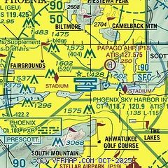
| Sectional chart |
|---|
|
CAUTION: Diagram may not be current
 Download PDF
of official airport diagram from the FAA
| Airport distance calculator |
|---|
|
|
| Sunrise and sunset |
|---|
|
Times for 31-May-2026
| | Local
(UTC-7) | | Zulu
(UTC) |
|---|
| Morning civil twilight | | 04:52 | | 11:52 |
| Sunrise | | 05:20 | | 12:20 |
| Sunset | | 19:31 | | 02:31 |
| Evening civil twilight | | 19:59 | | 02:59 |
|
| Current date and time |
|---|
| Zulu (UTC) | 01-Jun-2026 01:15:55 |
|---|
| Local (UTC-7) | 31-May-2026 18:15:55 |
|---|
|
| METAR |
|---|
KPHX
2nm W | 010051Z VRB03KT 10SM CLR 36/M01 A2975 RMK AO2 SLP055 T03561011
|
KSDL
12nm NE | 010053Z 25003KT 10SM CLR 34/M02 A2980 RMK AO2 SLP066 T03441022
|
KCHD
14nm SE | 010047Z 22008KT 10SM CLR 36/M01 A2977
|
KFFZ
15nm E | 010054Z 26005KT 10SM CLR 34/M02 A2977 RMK AO2 SLP059 T03441017
|
KDVT
15nm N | 010053Z 24008KT 10SM CLR 34/M03 A2979 RMK AO2 SLP064 T03441033
|
KGEU
16nm W | 010047Z 24007KT 10SM CLR 36/M04 A2974
|
KGYR
18nm W | 010047Z 27010KT 10SM SKC 36/M01 A2976
|
KLUF
18nm W | 010055Z AUTO 23003KT 10SM CLR 36/M10 A2975 RMK AO2 SLP059 T03591097 $
|
KIWA
20nm SE | 010051Z 26010KT 10SM CLR 35/00 A2979
|
|
| TAF |
|---|
KPHX
2nm W | 312031Z 3121/0124 26008KT P6SM SKC FM010900 10005KT P6SM SKC FM012000 25008KT P6SM FEW250
|
KSDL
12nm NE | 311720Z 3118/0118 VRB03KT P6SM SKC FM312000 23006KT P6SM SKC FM010400 VRB03KT P6SM SKC
|
KDVT
15nm N | 311720Z 3118/0118 23007KT P6SM SKC FM010600 VRB03KT P6SM SKC
|
KIWA
20nm SE | 311720Z 3118/0118 28007KT P6SM SKC FM010600 12007KT P6SM SKC
|
|
| NOTAMs |
|---|
NOTAMs are issued by the DoD/FAA and will open in a separate window not controlled by AirNav.
|
|


