FAA INFORMATION EFFECTIVE 09 JULY 2026
Location
| FAA Identifier: | DVT |
| Lat/Long: | 33-41-17.9000N 112-04-57.2000W
33-41.298333N 112-04.953333W
33.6883056,-112.0825556
(estimated) |
| Elevation: | 1478.1 ft. / 450.5 m (surveyed) |
| Variation: | 12E (2000) |
| From city: | 15 miles N of PHOENIX, AZ |
| Time zone: | UTC -7 (year round; does not observe DST) |
| Zip code: | 85027 |
Airport Operations
| Airport use: | Open to the public |
| Activation date: | 09/1959 |
| Control tower: | yes |
| ARTCC: | ALBUQUERQUE CENTER |
| FSS: | PRESCOTT FLIGHT SERVICE STATION |
| NOTAMs facility: | DVT (NOTAM-D service available) |
| Attendance: | CONTINUOUS
ADMIN - 0600-2100. |
| Pattern altitude: | TPA-2500 (1022) PISTON ENGINE AND 3000 (1522) TURBINE ENGINE. |
| Wind indicator: | lighted |
| Segmented circle: | yes |
| Lights: | WHEN ATCT CLSD, REIL RWY 07R, 07L, 25R & 25L; PAPI RWY 07R, 07L, 25R & 25L; MIRL RWY 07R/25L & 07L/25R ON CONSLY. |
| Beacon: | white-green (lighted land airport)
Operates sunset to sunrise. |
Airport Communications
| CTAF: | 118.4 |
| UNICOM: | 122.95 |
| ATIS: | 126.5 |
| WX ASOS: | 126.5 (480-308-1230) |
| DEER VALLEY GROUND: | 121.8 [0600-0000] |
| DEER VALLEY TOWER: | 118.4 ;ARR FM 070-250 AND RWY 07R/25L DEP 120.2 ;ARR FM 251-069 AND RWY 07L/25R DEP, 0600-00 [0600-0000] |
| PHOENIX APPROACH: | 120.7 |
| PHOENIX DEPARTURE: | 120.7 |
| CLEARANCE DELIVERY: | 123.9 |
| BLYTHE STAR: | 124.1 |
| DSERT STAR: | 120.7 |
| SUNSS STAR: | 124.1 |
| WX ASOS at SDL (9 nm SE): | PHONE 480-483-3049 |
| WX AWOS-1 at 18AZ (12 nm NE): | 125.625 (480-488-7882) |
| WX AWOS-3 at GEU (14 nm SW): | PHONE 623-877-8609 |
| WX ASOS at PHX (16 nm S): | PHONE 602-551-6092 |
- EMERG FREQ 121.5 NOT AVBL AT ATCT.
- SAID IN USE. OPERATE TRANSPONDERS WITH ALTITUDE REPORTING MODE AND ADS-B (IF EQUIPPED) ENABLED ON ALL AIRPORT SURFACES.
Nearby radio navigation aids
| VOR radial/distance | | VOR name | | Freq | | Var |
|---|
| PXRr328/16.3 | | PHOENIX VORTAC | | 115.60 | | 12E |
| IWAr304/31.6 | | WILLIE VORTAC | | 113.30 | | 13E |
| BXKr055/39.7 | | BUCKEYE VORTAC | | 110.60 | | 14E |
Airport Services
| Fuel available: | 100LL JET-A+
100LL:CREDIT CARD SELF SVC AVBL H24. |
| Parking: | hangars and tiedowns |
| Airframe service: | MAJOR |
| Powerplant service: | MAJOR |
| Bottled oxygen: | HIGH |
| Bulk oxygen: | HIGH |
Runway Information
Runway 7R/25L
| Dimensions: | 8196 x 100 ft. / 2498 x 30 m |
| Surface: | asphalt, in good condition |
| Weight bearing capacity: | | Single wheel: | 65.0 | | Double wheel: | 93.0 | | Double tandem: | 178.0 |
|
| Runway edge lights: | medium intensity |
| RUNWAY 7R | | RUNWAY 25L |
| Latitude: | 33-41.210053N | | 33-41.304050N |
| Longitude: | 112-05.776135W | | 112-04.163602W |
| Elevation: | 1439.9 ft. | | 1478.1 ft. |
| Traffic pattern: | right | | left |
| Runway heading: | 074 magnetic, 086 true | | 254 magnetic, 266 true |
| Displaced threshold: | 898 ft. | | 916 ft. |
| Declared distances: | TORA:8196 TODA:8196 ASDA:8196 LDA:7299 | | TORA:8196 TODA:8196 ASDA:8196 LDA:7281 |
| Markings: | nonprecision, in good condition | | nonprecision, in good condition |
| Visual slope indicator: | 4-light PAPI on left (3.00 degrees glide path) | | 4-light PAPI on left (3.00 degrees glide path)
UNUSBL BYD 5-DEGS LEFT OF CTRLN AND 6-DEGS RIGHT OF CTRLN. |
| Runway end identifier lights: | yes | | yes |
| Touchdown point: | yes, no lights | | yes, no lights |
| Obstructions: | 38 ft. sign, 1257 ft. from runway, 359 ft. right of centerline, 27:1 slope to clear
APCH SLOPE 50:1 AT DTHR. | | 76 ft. hill, 2527 ft. from runway, 565 ft. left of centerline, 30:1 slope to clear
APCH SLOPE 50:1 AT DTHR. |
Runway 7L/25R
| Dimensions: | 4500 x 75 ft. / 1372 x 23 m |
| Surface: | asphalt, in good condition |
| Weight bearing capacity: | | Single wheel: | 119.0 | | Double wheel: | 186.0 | | Double tandem: | 315.0 |
|
| Runway edge lights: | medium intensity |
| Operational restrictions: | TRNG RWY. |
| RUNWAY 7L | | RUNWAY 25R |
| Latitude: | 33-41.349600N | | 33-41.401213N |
| Longitude: | 112-05.367103W | | 112-04.481735W |
| Elevation: | 1455.1 ft. | | 1476.8 ft. |
| Traffic pattern: | left | | right |
| Runway heading: | 074 magnetic, 086 true | | 254 magnetic, 266 true |
| Markings: | nonprecision, in good condition | | nonprecision, in good condition |
| Visual slope indicator: | 4-light PAPI on left (3.50 degrees glide path) | | 4-light PAPI on left (4.00 degrees glide path) |
| Runway end identifier lights: | yes | | yes |
| Touchdown point: | yes, no lights | | yes, no lights |
| Obstructions: | none | | 180 ft. hill, lighted, 3732 ft. from runway, 122 ft. left of centerline, 19:1 slope to clear |
Airport Ownership and Management from official FAA records
| Ownership: | Publicly-owned |
| Owner: | CITY OF PHOENIX
3400 SKY HARBOR BLVD
PHOENIX, AZ 85034
Phone 623-869-0975 |
| Manager: | ED FARON
702 W DEER VALLEY DR
PHOENIX, AZ 85027
Phone 623-869-0975
EMERG - 623-869-0977. |
Additional Remarks
| - | CTN: LGTD HILLS NE, E, SE & W; HOT AIR BLN OPS N, NE & NW; PILOT TRNG WI 20 NM; AEROBATIC PRACTICE AREA 8.5 MI NW; SFC-6000 MSL. |
| - | SPL ATC RULE (SATR) IN EFCT W OF ARPT; CK SECTIONAL/TAC. |
| - | TWY D1 & D13 RUNUP PADS CLSD TO WINGSPAN MORE THAN 49 FT. |
| - | FOR CD WHEN ATCT CLSD, CTC PHOENIX APCH AT 602-306-2565. |
| - | CHARTER, TRAVEL CLUB & REVENUE ACFT FEE. |
| - | BIRDS & WILDLIFE ON & INVOF ARPT. |
Instrument Procedures
NOTE: All procedures below are presented as PDF files. If you need a reader for these files, you should download the free Adobe Reader.NOT FOR NAVIGATION. Please procure official charts for flight.
FAA instrument procedures published for use from 09 July 2026 at 0901Z to 06 August 2026 at 0900Z.
STARs - Standard Terminal Arrivals |
|---|
| ARLIN FOUR **NEW** | |
download (285KB) |
| BLYTHE FIVE **NEW** | |
download (255KB) |
| DSERT TWO (RNAV) **NEW** | |
2 pages:
[1] [2] (311KB) |
| SUNSS EIGHT **NEW** | |
download (237KB) |
IAPs - Instrument Approach Procedures |
|---|
| RNAV (GPS) RWY 07R | |
download (254KB) |
| RNAV (GPS) RWY 25L | |
download (265KB) |
| RNAV (GPS)-B | |
download (203KB) |
| NOTE: Special Alternate Minimums apply | |
download (141KB) |
Departure Procedures |
|---|
| BNYRD SIX (RNAV) | |
download (162KB) |
| FTHLS SIX (RNAV) | |
download (215KB) |
| IZZZO EIGHT (RNAV) | |
download (206KB) |
| JUDTH SEVEN (RNAV) | |
download (158KB) |
| KATMN SIX (RNAV) | |
download (160KB) |
| LALUZ SIX (RNAV) | |
download (221KB) |
| MAYSA SEVEN (RNAV) | |
download (159KB) |
| SNOBL SIX (RNAV) | |
download (224KB) |
| YOTES SIX (RNAV) | |
download (187KB) |
|
|---|
| DEER VALLEY THREE (OBSTACLE) | |
2 pages:
[1] [2] (651KB) |
| NOTE: Special Take-Off Minimums/Departure Procedures apply | |
download (379KB) |
Other nearby airports with instrument procedures:
KSDL - Scottsdale Airport (9 nm SE)
KGEU - Glendale Regional Airport (14 nm SW)
KPHX - Phoenix Sky Harbor International Airport (16 nm S)
KLUF - Luke Air Force Base (18 nm SW)
KGYR - Phoenix Goodyear Airport (22 nm SW)
|
|

Road maps at:
MapQuest
Bing
Google
| Aerial photo |
|---|
WARNING: Photo may not be current or correct
 Photo by Andreas Lauschke
Photo taken 07-Dec-2024
looking northeast.
Photo by Andreas Lauschke
Photo taken 07-Dec-2024
looking northeast.
Do you have a better or more recent aerial photo of Phoenix Deer Valley Airport that you would like to share? If so, please send us your photo.
|
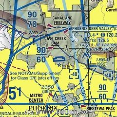
| Sectional chart |
|---|
|
CAUTION: Diagram may not be current
 Download PDF
of official airport diagram from the FAA
| Airport distance calculator |
|---|
|
|
| Sunrise and sunset |
|---|
|
Times for 15-Jul-2026
| | Local
(UTC-7) | | Zulu
(UTC) |
|---|
| Morning civil twilight | | 05:02 | | 12:02 |
| Sunrise | | 05:30 | | 12:30 |
| Sunset | | 19:39 | | 02:39 |
| Evening civil twilight | | 20:07 | | 03:07 |
|
| Current date and time |
|---|
| Zulu (UTC) | 15-Jul-2026 19:17:11 |
|---|
| Local (UTC-7) | 15-Jul-2026 12:17:11 |
|---|
|
| METAR |
|---|
| KDVT | 151853Z 18006KT 10SM CLR 37/16 A2989 RMK AO2 SLP089 T03670156 $
|
KSDL
9nm SE | 151853Z 15009KT 130V190 10SM CLR 37/16 A2989 RMK AO2 SLP090 T03720156
|
KGEU
14nm SW | 151850Z 20010KT 10SM SCT150 39/14 A2982
|
KPHX
15nm S | 151851Z VRB03KT 10SM FEW110 SCT150 BKN180 BKN250 38/16 A2985 RMK AO2 SLP083 T03830161 $
|
KLUF
18nm SW | 151755Z 14005KT 10SM BKN140 39/13 A2985 RMK AO2A SLP089 T03890133 10389 20328 50001 $
|
|
| TAF |
|---|
| KDVT | 151727Z 1518/1618 19007KT P6SM FEW120 SCT150 FM152000 24007KT P6SM FEW100 SCT150 FM152300 36018G26KT P6SM VCTS SCT100CB SCT150 BKN180 PROB30 1523/1602 5SM -TSRA BKN080CB FM160200 08010KT P6SM VCSH SCT090 BKN150 FM160900 VRB05KT P6SM FEW090 BKN120 FM161600 24008KT P6SM SCT090 BKN120
|
KSDL
9nm SE | 151727Z 1518/1618 VRB05KT P6SM FEW120 SCT150 FM152000 25007KT P6SM FEW100 SCT150 FM152300 01018G26KT P6SM VCTS SCT100CB SCT150 BKN180 PROB30 1523/1602 5SM -TSRA BKN080CB FM160200 12009KT P6SM VCSH SCT090 BKN150 FM160500 VRB05KT P6SM VCSH SCT090 BKN150 FM160800 VRB05KT P6SM FEW090 BKN120
|
KPHX
15nm S | 151727Z 1518/1624 VRB05KT P6SM FEW120 SCT150 FM152000 25008KT P6SM FEW100 SCT150 FM160000 01017G25KT P6SM VCTS SCT100CB SCT150 BKN180 PROB30 1600/1602 5SM -TSRA BKN080CB FM160300 10010KT P6SM VCSH SCT090 BKN150 FM160900 VRB06KT P6SM FEW090 BKN120 FM161600 25007KT P6SM SCT090 BKN120
|
KLUF
18nm SW | 151200Z 1512/1618 VRB06KT 9999 FEW130 QNH2977INS BECMG 1521/1522 19009KT 9999 BKN120 QNH2973INS BECMG 1603/1604 24009KT 9999 VCTS SCT090CB BKN140 QNH2976INS TEMPO 1604/1606 VRB15G25KT 6000 -TSRA BKN120CB BECMG 1606/1607 24009KT 9999 NSW SCT120 BKN150 QNH2978INS TX41/1523Z TN32/1513Z
|
|
| NOTAMs |
|---|
NOTAMs are issued by the DoD/FAA and will open in a separate window not controlled by AirNav.
|
|


