FAA INFORMATION EFFECTIVE 26 DECEMBER 2024
Location
| FAA Identifier: | ELD |
| Lat/Long: | 33-13-16.4561N 092-48-42.2960W
33-13.274268N 092-48.704933W
33.2212378,-92.8117489
(estimated) |
| Elevation: | 276.8 ft. / 84.4 m (surveyed) |
| Variation: | 03E (2000) |
| From city: | 8 miles W of EL DORADO, AR |
| Time zone: | UTC -6 (UTC -5 during Daylight Saving Time) |
| Zip code: | 71730 |
Airport Operations
| Airport use: | Open to the public |
| Activation date: | 12/1944 |
| Control tower: | no |
| ARTCC: | FORT WORTH CENTER |
| FSS: | JONESBORO FLIGHT SERVICE STATION |
| NOTAMs facility: | ELD (NOTAM-D service available) |
| Attendance: | MON-FRI 0600-1730, ALL SUN 1030-1730, ALL SAT 1030-1730
FOR SVC AFT HRS CALL 870-312-6255; FEE CHRGD. |
| Wind indicator: | lighted |
| Segmented circle: | no |
| Lights: | DUSK-DAWN. HIRL RY 04/22 PRESET LOW INTST; TO INCR INTST & ACTVT MIRL RY 13/31; MALSR RY 22 & TWY LGTS - CTAF. |
| Beacon: | white-green (lighted land airport)
Operates sunset to sunrise. |
Airport Communications
| CTAF/UNICOM: | 123.0 |
| WX ASOS: | 118.325 (870-862-3090) |
- APCH/DEP CTL SVC PRVDD BY FORT WORTH ARTCC (ZFW) ON FREQS 128.2/269.1 (EL DORADO RCAG).
Nearby radio navigation aids
| VOR radial/distance | | VOR name | | Freq | | Var |
|---|
| ELDr231/4.0 | | EL DORADO VOR/DME | | 115.50 | | 07E |
| NDB name | | Hdg/Dist | | Freq | | Var | | ID |
|---|
| LADOS | | 224/5.7 | | 418 | | 03E | | EL | . .-.. |
Airport Services
| Fuel available: | 100LL JET-A+ |
| Parking: | hangars and tiedowns |
| Airframe service: | MAJOR |
| Powerplant service: | MAJOR |
Runway Information
Runway 4/22
| Dimensions: | 6601 x 150 ft. / 2012 x 46 m |
| Surface: | asphalt/aggregate friction seal coat, in fair condition |
| Weight bearing capacity: | | Single wheel: | 75.0 | | Double wheel: | 200.0 |
|
| Runway edge lights: | high intensity |
| RUNWAY 4 | | RUNWAY 22 |
| Latitude: | 33-12.836462N | | 33-13.593565N |
| Longitude: | 092-49.125847W | | 092-48.195520W |
| Elevation: | 258.7 ft. | | 259.4 ft. |
| Traffic pattern: | left | | left |
| Runway heading: | 043 magnetic, 046 true | | 223 magnetic, 226 true |
| Markings: | precision, in fair condition | | precision, in fair condition |
| Visual slope indicator: | 4-light PAPI on left (3.00 degrees glide path) | | 4-light PAPI on left (3.00 degrees glide path) |
| Approach lights: | | | MALSR: 1,400 foot medium intensity approach lighting system with runway alignment indicator lights |
| Touchdown point: | yes, no lights | | yes, no lights |
| Instrument approach: | | | ILS/DME |
| Obstructions: | 40 ft. trees, 1600 ft. from runway, 400 ft. right of centerline, 35:1 slope to clear | | none |
Runway 13/31
| Dimensions: | 5100 x 100 ft. / 1554 x 30 m |
| Surface: | asphalt, in good condition |
| Weight bearing capacity: | |
| Runway edge lights: | medium intensity |
| RUNWAY 13 | | RUNWAY 31 |
| Latitude: | 33-13.653075N | | 33-13.048848N |
| Longitude: | 092-49.110203W | | 092-48.414212W |
| Elevation: | 276.8 ft. | | 243.2 ft. |
| Traffic pattern: | left | | left |
| Runway heading: | 133 magnetic, 136 true | | 313 magnetic, 316 true |
| Markings: | nonprecision, in good condition | | nonprecision, in good condition |
| Visual slope indicator: | 2-light PAPI on left (4.00 degrees glide path)
PAPI UNUSBL BYD 9 DEGS LEFT AND 6 DEGS RIGHT OF CNTRLN. | | 2-light PAPI on right (4.00 degrees glide path)
PAPI UNUSBL BYD 7 DEGS LEFT AND RIGHT OF CNTRLN. |
| Touchdown point: | yes, no lights | | yes, no lights |
Airport Ownership and Management from official FAA records
| Ownership: | Publicly-owned |
| Owner: | CITY OF EL DORADO
PO BOX 2170
EL DORADO, AR 71730
Phone 870-881-4192 |
| Manager: | JOHNATHAN ESTES
418 AIRPORT DR.
EL DORADO, AR 71730
Phone 870-881-4192 |
Additional Remarks
| - | FOR CD IF UNA TO CTC ON FSS FREQ, CTC FORT WORTH ARTCC AT 817-858-7584. |
Instrument Procedures
NOTE: All procedures below are presented as PDF files. If you need a reader for these files, you should download the free Adobe Reader.NOT FOR NAVIGATION. Please procure official charts for flight.
FAA instrument procedures published for use from 26 December 2024 at 0901Z to 23 January 2025 at 0900z.
IAPs - Instrument Approach Procedures |
|---|
| ILS OR LOC RWY 22 | |
download (232KB) |
| RNAV (GPS) RWY 04 | |
download (208KB) |
| RNAV (GPS) RWY 22 | |
download (245KB) |
| VOR/DME RWY 04 | |
download (178KB) |
| NOTE: Special Take-Off Minimums/Departure Procedures apply | |
download (380KB) |
Other nearby airports with instrument procedures:
KAGO - Ralph C Weiser Field Airport (20 nm W)
KCDH - Harrell Field Airport (24 nm N)
KSPH - Springhill Airport (33 nm SW)
3M9 - Warren Municipal Airport (42 nm NE)
KMNE - Minden Airport (42 nm SW)
|
|

Road maps at:
MapQuest
Bing
Google
| Aerial photo |
|---|
WARNING: Photo may not be current or correct
 Photo courtesy of the Arkansas Department of Aeronautics
Taken in the Spring of 2007
Photo courtesy of the Arkansas Department of Aeronautics
Taken in the Spring of 2007
Do you have a better or more recent aerial photo of South Arkansas Regional Airport at Goodwin Field that you would like to share? If so, please send us your photo.
|
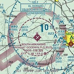
| Sectional chart |
|---|
|
| Airport distance calculator |
|---|
|
|
| Sunrise and sunset |
|---|
|
Times for 15-Jan-2025
| | Local
(UTC-6) | | Zulu
(UTC) |
|---|
| Morning civil twilight | | 06:49 | | 12:49 |
| Sunrise | | 07:16 | | 13:16 |
| Sunset | | 17:26 | | 23:26 |
| Evening civil twilight | | 17:53 | | 23:53 |
|
| Current date and time |
|---|
| Zulu (UTC) | 15-Jan-2025 12:09:45 |
|---|
| Local (UTC-6) | 15-Jan-2025 06:09:45 |
|---|
|
| METAR |
|---|
| KELD | 151153Z AUTO 00000KT 10SM CLR M03/M04 A3044 RMK AO2 SLP310 T10331039 10000 21039 51010
|
|
| TAF |
|---|
| KELD | 151120Z 1512/1612 VRB03KT P6SM SCT100 SCT250 FM151800 VRB04KT P6SM SCT100 BKN250 FM160000 00000KT P6SM SCT250
|
|
| NOTAMs |
|---|
NOTAMs are issued by the DoD/FAA and will open in a separate window not controlled by AirNav.
|
|


