FAA INFORMATION EFFECTIVE 16 APRIL 2026
Location
| FAA Identifier: | F00 |
| Lat/Long: | 33-36-47.1300N 096-10-45.5700W
33-36.785500N 096-10.759500W
33.6130917,-96.1793250
(estimated) |
| Elevation: | 618.2 ft. / 188.4 m (surveyed) |
| Variation: | 06E (1990) |
| From city: | 2 miles N of BONHAM, TX |
| Time zone: | UTC -5 (UTC -6 during Standard Time) |
| Zip code: | 75418 |
Airport Operations
| Airport use: | Open to the public |
| Activation date: | 11/1938 |
| Control tower: | no |
| ARTCC: | FORT WORTH CENTER |
| FSS: | FORT WORTH FLIGHT SERVICE STATION |
| NOTAMs facility: | FTW (NOTAM-D service available) |
| Attendance: | UNATNDD
FOR ARPT ATTENDANT CALL 903-583-7555 M-F 8:00-5:00. AFT HRS CALL BONHAM POLICE DEPT 903-583-2141. |
| Wind indicator: | lighted |
| Segmented circle: | yes |
| Lights: | MIRL RWY 17 & 35 SS-SR PRESET LOW; TO ACTVT OR INCR INTST - CTAF. PAPI RWY 17 & PAPI RWY 35 OPR CONSLY. |
| Beacon: | white-green (lighted land airport)
Operates sunset to sunrise. |
Airport Communications
| CTAF/UNICOM: | 122.8 |
| WX AWOS-3PT: | 118.05 (903-583-2082) |
- UNICOM UNMONITORED.
- APCH/DEP SVC PRVDD BY FORT WORTH ARTCC (ZFW) ON FREQS 124.875/370.95 (BONHAM RCAG).
Nearby radio navigation aids
| VOR radial/distance | | VOR name | | Freq | | Var |
|---|
| BYPr025/5.3 | | BONHAM VORTAC | | 114.60 | | 06E |
| PRXr270/36.8 | | PARIS VOR/DME | | 113.60 | | 07E |
| NDB name | | Hdg/Dist | | Freq | | Var | | ID |
|---|
| DENISON | | 115/27.6 | | 341 | | 03E | | DNI | -.. -. .. |
Airport Services
| Fuel available: | 100LL JET-A+
100LL:100 LL SELF-SERV.
A+:JET A FULL SERV. CALL 903-227-5199. |
| Parking: | tiedowns |
| Airframe service: | MAJOR
FOR AIRFRAME REPAIRS CALL 903-640-0233 OR 903-583-5119. |
| Powerplant service: | MAJOR |
| Bottled oxygen: | NONE |
| Bulk oxygen: | NONE |
Runway Information
Runway 17/35
| Dimensions: | 4000 x 75 ft. / 1219 x 23 m |
| Surface: | asphalt, in excellent condition |
| Weight bearing capacity: | |
| Runway edge lights: | medium intensity |
| RUNWAY 17 | | RUNWAY 35 |
| Latitude: | 33-37.115000N | | 33-36.455750N |
| Longitude: | 096-10.748000W | | 096-10.770833W |
| Elevation: | 617.9 ft. | | 612.3 ft. |
| Traffic pattern: | left | | left |
| Runway heading: | 176 magnetic, 182 true | | 356 magnetic, 002 true |
| Markings: | nonprecision, in good condition | | nonprecision, in good condition |
| Visual slope indicator: | 2-light PAPI on left (3.00 degrees glide path) | | 2-light PAPI on left (3.00 degrees glide path) |
| Touchdown point: | yes, no lights | | yes, no lights |
| Obstructions: | 22 ft. trees, 540 ft. from runway, 260 ft. right of centerline, 15:1 slope to clear
ALSO 43 FT PLINE, 1315 FT DSTC, 225 L/R, 25:1. | | 18 ft. ant, 425 ft. from runway, 175 ft. left of centerline, 12:1 slope to clear
33 FT TREES, 0-50 FT DSTC, 239 FT L; 4 FT FENCE, 0-100 FT DSTC, 190 FT L. |
Airport Ownership and Management from official FAA records
| Ownership: | Publicly-owned |
| Owner: | CITY OF BONHAM
514 CHESTNUT
BONHAM, TX 75418
Phone 903-583-7555 |
| Manager: | ZACK WHITLOCK
514 CHESTNUT
BONHAM, TX 75418
Phone 903-583-8623
DIRECTOR OF PUBLIC WORKS. |
Additional Remarks
| - | FOR CD CTC FORT WORTH ARTCC AT 817-858-7584. |
| - | EXTSV AERIAL AG OPS APR-AUG. OTR TIMES IREG. |
Instrument Procedures
NOTE: All procedures below are presented as PDF files. If you need a reader for these files, you should download the free Adobe Reader.NOT FOR NAVIGATION. Please procure official charts for flight.
FAA instrument procedures published for use from 16 April 2026 at 0901Z to 14 May 2026 at 0900Z.
IAPs - Instrument Approach Procedures |
|---|
| RNAV (GPS) RWY 17 | |
download (222KB) |
| RNAV (GPS) RWY 35 | |
download (196KB) |
| VOR/DME RWY 17 | |
download (165KB) |
| NOTE: Special Alternate Minimums apply | |
download (139KB) |
| NOTE: Special Take-Off Minimums/Departure Procedures apply | |
download (302KB) |
Other nearby airports with instrument procedures:
KSWI - Sherman Municipal Airport (20 nm W)
KDUA - Durant Regional Airport - Eaker Field (22 nm NW)
2F7 - Commerce Municipal Airport (24 nm SE)
KGYI - North Texas Regional Airport/Perrin Field (25 nm W)
KGVT - Majors Airport (33 nm S)
|
|

Road maps at:
MapQuest
Bing
Google
| Aerial photo |
|---|
WARNING: Photo may not be current or correct
 Photo by Mike Porter
looking southwest.
Photo by Mike Porter
looking southwest.
Do you have a better or more recent aerial photo of Jones Field Airport that you would like to share? If so, please send us your photo.
|
| Sectional chart |
|---|
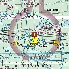
|
| Airport distance calculator |
|---|
|
|
| Sunrise and sunset |
|---|
|
Times for 24-Apr-2026
| | Local
(UTC-5) | | Zulu
(UTC) |
|---|
| Morning civil twilight | | 06:18 | | 11:18 |
| Sunrise | | 06:45 | | 11:45 |
| Sunset | | 20:01 | | 01:01 |
| Evening civil twilight | | 20:27 | | 01:27 |
|
| Current date and time |
|---|
| Zulu (UTC) | 25-Apr-2026 03:04:08 |
|---|
| Local (UTC-5) | 24-Apr-2026 22:04:08 |
|---|
|
| METAR |
|---|
| KF00 | 250255Z AUTO 05011G18KT 10SM CLR 20/17 A2969 RMK AO2 LTG DSNT E AND SE
|
|
| TAF |
|---|
KDUA
23nm NW | 250013Z 2500/2524 01018G29KT P6SM FEW028 FEW060 FEW080 PROB30 2500/2501 05020G25KT 4SM -TSRA BKN040CB FM250100 05010KT P6SM BKN050 BKN250 FM251000 08003KT P6SM BKN007 FM251600 14011KT P6SM BKN015 FM251900 17011G18KT P6SM BKN035
|
|
| NOTAMs |
|---|
NOTAMs are issued by the DoD/FAA and will open in a separate window not controlled by AirNav.
|
|


