FAA INFORMATION EFFECTIVE 09 JULY 2026
Location
| FAA Identifier: | SWI |
| Lat/Long: | 33-37-26.9000N 096-35-10.1000W
33-37.448333N 096-35.168333W
33.6241389,-96.5861389
(estimated) |
| Elevation: | 746.1 ft. / 227.4 m (surveyed) |
| Variation: | 03E (2015) |
| From city: | 1 mile SE of SHERMAN, TX |
| Time zone: | UTC -5 (UTC -6 during Standard Time) |
| Zip code: | 75090 |
Airport Operations
| Airport use: | Open to the public |
| Activation date: | 08/1937 |
| Control tower: | no |
| ARTCC: | FORT WORTH CENTER |
| FSS: | FORT WORTH FLIGHT SERVICE STATION |
| NOTAMs facility: | FTW (NOTAM-D service available) |
| Attendance: | 0800-1700 |
| Wind indicator: | lighted |
| Segmented circle: | yes |
| Lights: | MIRL RWY 16/34 PRESET LOW INTST; TO INCR INTST AND ACTVT - CTAF. |
| Beacon: | white-green (lighted land airport)
Operates sunset to sunrise. |
Airport Communications
| CTAF/UNICOM: | 122.8 |
| WX AWOS-3PT at GYI (7 nm NW): | 118.775 (903-786-7790) |
- APCH/DEP CTL SVC PRVDD BY FORT WORTH ARTCC (ZFW) ON FREQS 124.75/323.0 (GAINESVILLE RCAG).
Nearby radio navigation aids
| VOR radial/distance | | VOR name | | Freq | | Var |
|---|
| BYPr280/18.3 | | BONHAM VORTAC | | 114.60 | | 06E |
| NDB name | | Hdg/Dist | | Freq | | Var | | ID |
|---|
| DENISON | | 158/12.8 | | 341 | | 03E | | DNI | -.. -. .. |
Airport Services
| Fuel available: | 100LL
100LL:FUEL SELF SERVE. |
| Parking: | tiedowns |
| Airframe service: | MAJOR |
| Powerplant service: | MAJOR |
| Bottled oxygen: | NONE |
| Bulk oxygen: | NONE |
Runway Information
Runway 16/34
| Dimensions: | 4000 x 75 ft. / 1219 x 23 m |
| Surface: | asphalt, in poor condition
EXTSV CRACKING. |
| Weight bearing capacity: | |
| Runway edge lights: | medium intensity |
| Runway edge markings: | MKGS DISCOLORED. |
| RUNWAY 16 | | RUNWAY 34 |
| Latitude: | 33-37.768012N | | 33-37.127895N |
| Longitude: | 096-35.262710W | | 096-35.072795W |
| Elevation: | 746.0 ft. | | 711.9 ft. |
| Traffic pattern: | left | | left |
| Runway heading: | 163 magnetic, 166 true | | 343 magnetic, 346 true |
| Markings: | nonprecision, in poor condition | | nonprecision, in poor condition |
| Touchdown point: | yes, no lights | | yes, no lights |
| Obstructions: | 30 ft. trees, 530 ft. from runway, 250 ft. right of centerline, 10:1 slope to clear | | 14 ft. pline, 700 ft. from runway, 34:1 slope to clear
22 FT TREES, 0-199 FT DSTC, 220 FT L. |
Airport Ownership and Management from official FAA records
| Ownership: | Publicly-owned |
| Owner: | CITY OF SHERMAN
PO BOX 1106
SHERMAN, TX 75090
Phone 903-892-7206 |
| Manager: | JOHN HOOKER
1200 S. DEWEY AVE
SHERMAN, TX 75090
Phone 903-868-4412 |
Additional Remarks
| - | CITY ORDINANCE MANDATES ALL TAKE-OFFS ON RY 34 COMMENCE AT THLD MARKINGS. HIGH SPEED, LOW LEVEL PASSES ARE PROHIBITED. |
| - | FOR CD CTC FORT WORTH ARTCC AT 817-858-7584. |
Instrument Procedures
NOTE: All procedures below are presented as PDF files. If you need a reader for these files, you should download the free Adobe Reader.NOT FOR NAVIGATION. Please procure official charts for flight.
FAA instrument procedures published for use from 09 July 2026 at 0901Z to 06 August 2026 at 0900Z.
IAPs - Instrument Approach Procedures |
|---|
| RNAV (GPS) RWY 16 | |
download (248KB) |
| RNAV (GPS) RWY 34 | |
download (209KB) |
| VOR/DME-A | |
download (196KB) |
| NOTE: Special Take-Off Minimums/Departure Procedures apply | |
download (118KB) |
Other nearby airports with instrument procedures:
KGYI - North Texas Regional Airport/Perrin Field (7 nm NW)
F00 - Jones Field Airport (20 nm E)
KDUA - Durant Regional Airport - Eaker Field (21 nm NE)
KTKI - McKinney National Airport (27 nm S)
KGLE - Gainesville Municipal Airport (31 nm W)
|
|

Road maps at:
MapQuest
Bing
Google
| Aerial photo |
|---|
WARNING: Photo may not be current or correct
 Photo by Kurtis K. Samples, AMS
Photo taken 27-Mar-2012
looking southeast.
Photo by Kurtis K. Samples, AMS
Photo taken 27-Mar-2012
looking southeast.
Do you have a better or more recent aerial photo of Sherman Municipal Airport that you would like to share? If so, please send us your photo.
|
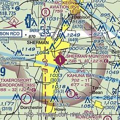
| Sectional chart |
|---|
|
CAUTION: Diagram may not be current

| Airport distance calculator |
|---|
|
|
| Sunrise and sunset |
|---|
|
Times for 31-Jul-2026
| | Local
(UTC-5) | | Zulu
(UTC) |
|---|
| Morning civil twilight | | 06:11 | | 11:11 |
| Sunrise | | 06:39 | | 11:39 |
| Sunset | | 20:27 | | 01:27 |
| Evening civil twilight | | 20:54 | | 01:54 |
|
| Current date and time |
|---|
| Zulu (UTC) | 01-Aug-2026 02:37:27 |
|---|
| Local (UTC-5) | 31-Jul-2026 21:37:27 |
|---|
|
| METAR |
|---|
KGYI
7nm NW | 010215Z AUTO 19009KT 10SM CLR 32/20 A2985 RMK AO2 T03220198 $
|
|
| TAF |
|---|
KDUA
22nm NE | 311720Z 3118/0118 24011G17KT P6SM SCT250 FM312000 21011KT P6SM SCT070 BKN150 FM010200 VRB05KT P6SM SCT150 BKN250 FM011400 01010G18KT P6SM SKC
|
|
| NOTAMs |
|---|
NOTAMs are issued by the DoD/FAA and will open in a separate window not controlled by AirNav.
|
|


