FAA INFORMATION EFFECTIVE 16 APRIL 2026
Location
| FAA Identifier: | F37 |
| Lat/Long: | 33-38-56.0500N 105-53-46.3920W
33-38.934167N 105-53.773200W
33.6489028,-105.8962200
(estimated) |
| Elevation: | 5372.9 ft. / 1638 m (estimated) |
| Variation: | 11E (1985) |
| From city: | 1 mile NW of CARRIZOZO, NM |
| Time zone: | UTC -6 (UTC -7 during Standard Time) |
| Zip code: | 88301 |
Airport Operations
| Airport use: | Open to the public |
| Activation date: | 01/1965 |
| Control tower: | no |
| ARTCC: | ALBUQUERQUE CENTER |
| FSS: | ALBUQUERQUE FLIGHT SERVICE STATION |
| NOTAMs facility: | ABQ (NOTAM-D service available) |
| Attendance: | CONTINUOUS |
| Wind indicator: | lighted |
| Segmented circle: | yes |
| Lights: | ACTVT REIL RWY 06 & 24; PAPI RWY 06 & 24; MIRL RWY 06/24 - CTAF. |
| Beacon: | white-green (lighted land airport)
Operates sunset to sunrise. |
Airport Communications
Nearby radio navigation aids
| NDB name | | Hdg/Dist | | Freq | | Var | | ID |
|---|
| CAPITAN | | 281/26.4 | | 278 | | 10E | | CEP | -.-. . .--. |
Airport Services
| Fuel available: | 100LL |
| Parking: | hangars and tiedowns |
| Airframe service: | MINOR |
| Powerplant service: | MINOR |
Runway Information
Runway 6/24
| Dimensions: | 4944 x 75 ft. / 1507 x 23 m |
| Surface: | asphalt, in good condition |
| Weight bearing capacity: | | PCN 5 /F/C/Y/T | | Single wheel: | 12.0 |
|
| Runway edge lights: | medium intensity |
| Runway edge markings: | NRS & CNTRLN FADED OR NA. |
| RUNWAY 6 | | RUNWAY 24 |
| Latitude: | 33-38.754667N | | 33-39.046667N |
| Longitude: | 105-54.293833W | | 105-53.383000W |
| Elevation: | 5356.9 ft. | | 5359.0 ft. |
| Traffic pattern: | left | | left |
| Runway heading: | 058 magnetic, 069 true | | 238 magnetic, 249 true |
| Markings: | basic, in poor condition | | basic, in poor condition |
| Visual slope indicator: | 2-light PAPI on left (3.00 degrees glide path)
PAPI OTS INDEFLY. | | 2-light PAPI on left (3.00 degrees glide path)
PAPI OTS INDEFLY. |
| Runway end identifier lights: | yes | | yes |
| Touchdown point: | yes, no lights | | yes, no lights |
Runway 15/33
| Dimensions: | 2500 x 90 ft. / 762 x 27 m |
| Surface: | dirt, in fair condition |
| Operational restrictions: | BDRY MKRS 72 FT L & R OF CNTRLN; +2 FT METAL THR MKRS 45 FT L & R; 2-3 FT BRUSH INSIDE MKRS. |
| RUNWAY 15 | | RUNWAY 33 |
| Latitude: | 33-39.193000N | | 33-38.807833N |
| Longitude: | 105-53.731833W | | 105-53.556333W |
| Elevation: | 5342.1 ft. | | 5372.9 ft. |
| Traffic pattern: | left | | left |
| Runway heading: | 149 magnetic, 160 true | | 329 magnetic, 340 true |
| Touchdown point: | yes, no lights | | yes, no lights |
| Obstructions: | 5 ft. brush, 20 ft. from runway, 4:1 slope to clear | | none |
Airport Ownership and Management from official FAA records
| Ownership: | Publicly-owned |
| Owner: | TOWN OF CARRIZOZO
PO BOX 247
CARRIZOZO, NM 88301
Phone 575-648-2371 |
| Manager: | BILL HAYES
PO BOX 597
CARRIZOZO, NM 88301
Phone 575-648-5380
575-648-1118 |
Additional Remarks
| A30A-33 | +2 FT BRUSH FM MKRS-200 FT L & R OF CNTRLN. |
| A30A-15 | +2 FT BRUSH FM MKRS TO FENCE L & R OF CNTRLN; 3 FT POLE 120 FT FM THR 45 FT L OF CNTRLN. |
| - | WILDLIFE ON & INVOF AIRPORT. |
| - | FOR CD CTC ALBUQUERQUE ARTCC AT 505-856-4861. |
| A58-24 | +2-3 FT BRUSH 0-200 FT FM THR 45-125 FT L & R. |
| A58-06 | +1 FT BRUSH 0-200 FT FM THR 0-125 FT L & R OF CNTRLN. |
Instrument Procedures
There are no published instrument procedures at F37.
Some nearby airports with instrument procedures:
KSRR - Sierra Blanca Regional Airport (22 nm SE)
KALM - Alamogordo-White Sands Regional Airport (49 nm S)
KHMN - Holloman Air Force Base (49 nm S)
KONM - Socorro Municipal Airport (55 nm NW)
KROW - Roswell Air Center Airport (72 nm E)
|
|

Road maps at:
MapQuest
Bing
Google
| Aerial photo |
|---|
WARNING: Photo may not be current or correct

Do you have a better or more recent aerial photo of Carrizozo Municipal Airport that you would like to share? If so, please send us your photo.
|
| Sectional chart |
|---|
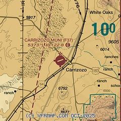
|
| Airport distance calculator |
|---|
|
|
| Sunrise and sunset |
|---|
|
Times for 28-Apr-2026
| | Local
(UTC-6) | | Zulu
(UTC) |
|---|
| Morning civil twilight | | 05:53 | | 11:53 |
| Sunrise | | 06:19 | | 12:19 |
| Sunset | | 19:43 | | 01:43 |
| Evening civil twilight | | 20:10 | | 02:10 |
|
| Current date and time |
|---|
| Zulu (UTC) | 28-Apr-2026 13:38:47 |
|---|
| Local (UTC-6) | 28-Apr-2026 07:38:47 |
|---|
|
| METAR |
|---|
KSRR
22nm SE | 281315Z AUTO 33008KT 10SM CLR 13/M13 A3011 RMK AO2 LTG DSNT W
|
|
| TAF |
|---|
KHMN
49nm S | 280900Z 2809/2915 17010KT 9999 SCT200 530009 530909 QNH3000INS BECMG 2817/2818 23010G20KT 9999 BKN200 530009 530909 QNH2995INS TEMPO 2821/2901 23015G25KT BECMG 2902/2903 17010KT 9999 SCT100 BKN200 QNH3005INS TX28/2822Z TN13/2812Z
|
|
| NOTAMs |
|---|
NOTAMs are issued by the DoD/FAA and will open in a separate window not controlled by AirNav.
|
|


