FAA INFORMATION EFFECTIVE 14 MAY 2026
Location
| FAA Identifier: | F89 |
| Lat/Long: | 32-09-10.9000N 091-41-54.9000W
32-09.181667N 091-41.915000W
32.1530278,-91.6985833
(estimated) |
| Elevation: | 78.3 ft. / 23.9 m (surveyed) |
| Variation: | 04E (1985) |
| From city: | 1 mile E of WINNSBORO, LA |
| Time zone: | UTC -5 (UTC -6 during Standard Time) |
| Zip code: | 71295 |
Airport Operations
| Airport use: | Open to the public |
| Activation date: | 06/1945 |
| Control tower: | no |
| ARTCC: | FORT WORTH CENTER |
| FSS: | DE RIDDER FLIGHT SERVICE STATION |
| NOTAMs facility: | DRI (NOTAM-D service available) |
| Attendance: | ON CALL
318-282-4524 |
| Wind indicator: | lighted |
| Segmented circle: | yes |
| Lights: | MIRL RWY 18/36 PRESET LOW INTS DUSK TO DAWN, TO INCR INTS ACTVT-CTAF. |
| Beacon: | white-green (lighted land airport)
Operates sunset to sunrise. |
Airport Communications
Nearby radio navigation aids
| VOR radial/distance | | VOR name | | Freq | | Var |
|---|
| MLUr139/27.7 | | MONROE VORTAC | | 117.20 | | 03E |
Airport Services
| Fuel available: | 100LL
100LL:FUEL AVBL 24 HRS SELF SERVE WITH CC. |
| Parking: | tiedowns |
| Airframe service: | MINOR |
| Powerplant service: | MINOR |
| Bottled oxygen: | NONE |
| Bulk oxygen: | NONE |
Runway Information
Runway 18/36
| Dimensions: | 3001 x 75 ft. / 915 x 23 m |
| Surface: | asphalt, in fair condition |
| Weight bearing capacity: | |
| Runway edge lights: | medium intensity |
| RUNWAY 18 | | RUNWAY 36 |
| Latitude: | 32-09.429297N | | 32-08.934450N |
| Longitude: | 091-41.912577W | | 091-41.916240W |
| Elevation: | 75.5 ft. | | 78.1 ft. |
| Traffic pattern: | left | | left |
| Runway heading: | 176 magnetic, 180 true | | 356 magnetic, 000 true |
| Markings: | basic, in fair condition | | basic, in fair condition |
| Visual slope indicator: | 2-light PAPI on left (3.75 degrees glide path) | | 2-light PAPI on left (3.10 degrees glide path) |
| Runway end identifier lights: | | | yes |
| Touchdown point: | yes, no lights | | yes, no lights |
| Obstructions: | 81 ft. tree, 1313 ft. from runway, 230 ft. left of centerline, 13:1 slope to clear | | 45 ft. trees, 839 ft. from runway, 158 ft. right of centerline, 14:1 slope to clear |
Airport Ownership and Management from official FAA records
| Ownership: | Publicly-owned |
| Owner: | CITY OF WINNSBORO
PO BOX 250
WINNSBORO, LA 71295
Phone 318-435-9087 |
| Manager: | TERRY SHIRLEY
PO BOX 250
WINNSBORO, LA 71295
Phone (318) 439-3676 |
Additional Remarks
| - | HEAVY AGRI ACFT OPS JUNE THRU OCT. |
| - | RWY 18/36 TREES WEST OF RWY OBST VIEW OF OPERATING ACFT. |
| - | FOR CD CTC MONROE APCH AT 318-327-5641, IF UNAVBL, CTC FORT WORTH ARTCC AT 817-858-7584. |
| - | CTC APRT MGR FOR DSGND RAMP SPACE FOR PUB USE. |
Instrument Procedures
There are no published instrument procedures at F89.
Some nearby airports with instrument procedures:
M79 - John H Hooks Jr Memorial Airport (20 nm N)
KMLU - Monroe Regional Airport (27 nm NW)
KTVR - Vicksburg Tallulah Regional Airport (36 nm E)
0R4 - Concordia Parish Airport (37 nm S)
KBQP - Morehouse Memorial Airport (37 nm N)
|
|

Road maps at:
MapQuest
Bing
Google
| Aerial photo |
|---|
WARNING: Photo may not be current or correct

Do you have a better or more recent aerial photo of Winnsboro Municipal Airport that you would like to share? If so, please send us your photo.
|
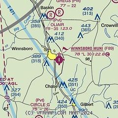
| Sectional chart |
|---|
|
| Airport distance calculator |
|---|
|
|
| Sunrise and sunset |
|---|
|
Times for 09-Jun-2026
| | Local
(UTC-5) | | Zulu
(UTC) |
|---|
| Morning civil twilight | | 05:33 | | 10:33 |
| Sunrise | | 06:01 | | 11:01 |
| Sunset | | 20:11 | | 01:11 |
| Evening civil twilight | | 20:39 | | 01:39 |
|
| Current date and time |
|---|
| Zulu (UTC) | 09-Jun-2026 14:59:39 |
|---|
| Local (UTC-5) | 09-Jun-2026 09:59:39 |
|---|
|
| METAR |
|---|
KMLU
28nm NW | 091408Z VRB05KT 10SM SCT013 29/24 A3012 RMK AO2 T02890244
|
KTVR
36nm E | 091453Z AUTO 10004KT 10SM SCT020 SCT027 29/24 A3013 RMK AO2 SLP208 T02890239 50002
|
K0R4
37nm S | 091435Z AUTO 13003KT 10SM SCT015 29/25 A3017 RMK AO2 T02920247
|
KBQP
37nm N | 091430Z AUTO 21003KT 29/24 A3013 RMK AO2 T02870235 PWINO
|
KHEZ
39nm SE | 091438Z AUTO 13006KT 9SM FEW016 27/22 A3014 RMK AO2 $
|
KVKS
39nm E | 091435Z AUTO 00000KT 10SM FEW019 29/25 A3011 RMK A01
|
KRSN
50nm NW | 091455Z AUTO VRB05KT 10SM BKN017 28/25 A3012 RMK AO2 CIG 014V021 T02810253 50008 $
|
|
| TAF |
|---|
KMLU
28nm NW | 091122Z 0912/1012 18003KT P6SM SCT020 TEMPO 0912/0916 BKN015 FM091600 20007KT P6SM SCT035 FM092000 19007KT P6SM SCT045 FM100300 17004KT P6SM FEW060
|
|
| NOTAMs |
|---|
NOTAMs are issued by the DoD/FAA and will open in a separate window not controlled by AirNav.
|
|

