FAA INFORMATION EFFECTIVE 19 MARCH 2026
Location
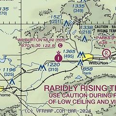
| FAA Identifier: | H05 |
| Lat/Long: | 34-55-12.7450N 095-23-38.0500W
34-55.212417N 095-23.634167W
34.9202069,-95.3939028
(estimated) |
| Elevation: | 669.8 ft. / 204 m (estimated) |
| Variation: | 06E (1985) |
| From city: | 4 miles W of WILBURTON, OK |
| Time zone: | UTC -5 (UTC -6 during Standard Time) |
| Zip code: | 74578 |
Airport Operations
| Airport use: | Open to the public |
| Activation date: | 03/1964 |
| Control tower: | no |
| ARTCC: | FORT WORTH CENTER |
| FSS: | MC ALESTER FLIGHT SERVICE STATION |
| NOTAMs facility: | MLC (NOTAM-D service available) |
| Attendance: | UNATNDD |
| Wind indicator: | lighted |
| Segmented circle: | yes |
| Lights: | ACTVT PAPI RWY 17 & 35; MIRL RWY 17/35 - CTAF. |
| Beacon: | white-green (lighted land airport)
Operates sunset to sunrise. |
Airport Communications
| CTAF: | 122.9 |
| WX ASOS at MLC (19 nm W): | 120.425 (918-426-7674) |
Airport Services
| Parking: | hangars and tiedowns |
Runway Information
Runway 17/35
| Dimensions: | 3000 x 60 ft. / 914 x 18 m |
| Surface: | asphalt, in good condition |
| Weight bearing capacity: | |
| Runway edge lights: | medium intensity |
| RUNWAY 17 | | RUNWAY 35 |
| Latitude: | 34-55.459833N | | 34-54.965000N |
| Longitude: | 095-23.635167W | | 095-23.633167W |
| Elevation: | 669.8 ft. | | 662.6 ft. |
| Traffic pattern: | left | | left |
| Runway heading: | 174 magnetic, 180 true | | 354 magnetic, 360 true |
| Markings: | basic, in good condition | | basic, in good condition |
| Visual slope indicator: | 2-light PAPI on left (3.00 degrees glide path) | | 2-light PAPI on left (3.00 degrees glide path) |
| Touchdown point: | yes, no lights | | yes, no lights |
| Obstructions: | 31 ft. trees, 285 ft. from runway, 139 ft. left of centerline, 2:1 slope to clear
36 FT TREE 179 FT FM THR 161 FT LEFT OF CNTRLN. | | 41 ft. trees, 487 ft. from runway, 207 ft. right of centerline, 7:1 slope to clear |
Airport Ownership and Management from official FAA records
| Ownership: | Publicly-owned |
| Owner: | CITY OF WILBURTON
CITY HALL, 300 W. MAIN
WILBURTON, OK 74578
Phone 918-465-5361 |
| Manager: | LORAN MAYES
CITY HALL, 300 W. MAIN
WILBURTON, OK 74578
Phone 918-465-5361
MAYOR MAYES |
Additional Remarks
| - | DEER ON & INVOF RWY. |
| - | FOR CD CTC FORT WORTH ARTCC AT 817-858-7584. |
| - | PARL TWY PAVEMENT FAILED; USE SOUTH CNCTR TWY TO APN. |
Instrument Procedures
There are no published instrument procedures at H05.
Some nearby airports with instrument procedures:
KMLC - Mc Alester Regional Airport (19 nm W)
KGZL - Stigler Regional Airport (27 nm NE)
KRKR - Robert S Kerr Airport (38 nm E)
F10 - Henryetta Municipal Airport (42 nm NW)
KJSV - Sallisaw Municipal Airport (42 nm NE)
|
|

Road maps at:
MapQuest
Bing
Google
| Aerial photo |
|---|
WARNING: Photo may not be current or correct

Do you have a better or more recent aerial photo of Wilburton Municipal Airport that you would like to share? If so, please send us your photo.
|
| Sectional chart |
|---|
|
| Airport distance calculator |
|---|
|
|
| Sunrise and sunset |
|---|
|
Times for 01-Apr-2026
| | Local
(UTC-5) | | Zulu
(UTC) |
|---|
| Morning civil twilight | | 06:44 | | 11:44 |
| Sunrise | | 07:09 | | 12:09 |
| Sunset | | 19:42 | | 00:42 |
| Evening civil twilight | | 20:07 | | 01:07 |
|
| Current date and time |
|---|
| Zulu (UTC) | 01-Apr-2026 16:40:32 |
|---|
| Local (UTC-5) | 01-Apr-2026 11:40:32 |
|---|
|
| METAR |
|---|
KMLC
19nm W | 011553Z AUTO 20011G21KT 10SM BKN021 BKN110 23/17 A2994 RMK AO2 SLP130 T02330172
|
KGZL
27nm NE | 011615Z AUTO 21016G22KT 10SM BKN026 BKN032 25/19 A2994 RMK AO2
|
|
| TAF |
|---|
KMLC
19nm W | 011124Z 0112/0212 18012G18KT P6SM BKN050 WS020/19040KT TEMPO 0113/0117 BKN025 FM011700 18014G22KT P6SM BKN040 FM020500 18012G22KT 6SM -SHRA BKN040 TEMPO 0205/0209 2SM -TSRA BKN015CB
|
|
| NOTAMs |
|---|
NOTAMs are issued by the DoD/FAA and will open in a separate window not controlled by AirNav.
|
|

