FAA INFORMATION EFFECTIVE 09 JULY 2026
Location
| FAA Identifier: | F10 |
| Lat/Long: | 35-24-24.7670N 096-00-56.9980W
35-24.412783N 096-00.949967W
35.4068797,-96.0158328
(estimated) |
| Elevation: | 849 ft. / 258.8 m (surveyed) |
| Variation: | 04E (2005) |
| From city: | 3 miles SW of HENRYETTA, OK |
| Time zone: | UTC -5 (UTC -6 during Standard Time) |
| Zip code: | 74437 |
Airport Operations
| Airport use: | Open to the public |
| Control tower: | no |
| ARTCC: | FORT WORTH CENTER |
| FSS: | MC ALESTER FLIGHT SERVICE STATION |
| NOTAMs facility: | MLC (NOTAM-D service available) |
| Attendance: | UNATNDD |
| Wind indicator: | lighted |
| Segmented circle: | yes |
| Lights: | DUSK-DAWN. ACTVT MIRL RY 18/36 - CTAF. |
| Beacon: | white-green (lighted land airport)
Operates sunset to sunrise. |
Airport Communications
| CTAF/UNICOM: | 122.8 |
| WX AWOS-3PT at OKM (16 nm N): | 118.225 (918-756-9502) |
- APCH/DEP CTL SVC PRVDD BY FORT WORTH ARTCC (ZFW) ON FREQS 132.2/338.35 (MC ALESTER RCAG).
Nearby radio navigation aids
| VOR radial/distance | | VOR name | | Freq | | Var |
|---|
| OKMr195/18.7 | | OKMULGEE VOR/DME | | 114.90 | | 08E |
| NDB name | | Hdg/Dist | | Freq | | Var | | ID |
|---|
| HENRYETTA | | at field | | 267 | | 04E | | HET | .... . - |
Airport Services
| Parking: | tiedowns |
| Airframe service: | NONE |
| Powerplant service: | NONE |
| Bottled oxygen: | NONE |
| Bulk oxygen: | NONE |
Runway Information
Runway 18/36
| Dimensions: | 3501 x 50 ft. / 1067 x 15 m |
| Surface: | asphalt, in fair condition |
| Weight bearing capacity: | |
| Runway edge lights: | medium intensity |
| Runway edge markings: | MARKINGS SEVERELY FADED. |
| RUNWAY 18 | | RUNWAY 36 |
| Latitude: | 35-24.701050N | | 35-24.123883N |
| Longitude: | 096-00.949100W | | 096-00.950333W |
| Elevation: | 830.0 ft. | | 849.0 ft. |
| Traffic pattern: | left | | left |
| Runway heading: | 176 magnetic, 180 true | | 356 magnetic, 360 true |
| Markings: | basic, in poor condition | | nonprecision, in poor condition |
| Visual slope indicator: | pulsating/steady burning VASI on left (3.50 degrees glide path) | | |
| Touchdown point: | yes, no lights | | yes, no lights |
| Obstructions: | 45 ft. trees, 330 ft. from runway, 140 ft. left of centerline, 2:1 slope to clear | | 27 ft. trees, 332 ft. from runway, 230 ft. right of centerline, 4:1 slope to clear
26 FT TREE 120 FT FM RWY 36 END 154 FT LEFT OF APCH. |
Airport Ownership and Management from official FAA records
| Ownership: | Publicly-owned |
| Owner: | CITY OF HENRYETTA
CITY HALL, 115 S. 4TH ST
HENRYETTA, OK 74437
Phone 918-652-3348 |
| Manager: | DAVID BOLLARD
PO BOX 608, 10249 LOBLOLLY RD.
HENRYETTA, OK 74437
Phone 918-652-3348 |
Additional Remarks
| - | FOR CD CTC FORT WORTH ARTCC AT 817-858-7584. |
Instrument Procedures
NOTE: All procedures below are presented as PDF files. If you need a reader for these files, you should download the free Adobe Reader.NOT FOR NAVIGATION. Please procure official charts for flight.
FAA instrument procedures published for use from 09 July 2026 at 0901Z to 06 August 2026 at 0900Z.
IAPs - Instrument Approach Procedures |
|---|
| RNAV (GPS) RWY 36 | |
download (202KB) |
| NOTE: Special Take-Off Minimums/Departure Procedures apply | |
download (131KB) |
Other nearby airports with instrument procedures:
KOKM - Okmulgee Regional Airport/Paul and Betty Abbott Field (16 nm N)
F99 - Holdenville Municipal Airport (28 nm SW)
3F7 - Jones Memorial Airport (31 nm NW)
KSRE - Seminole Municipal Airport (33 nm W)
KMLC - Mc Alester Regional Airport (33 nm S)
|
|

Road maps at:
MapQuest
Bing
Google
| Aerial photo |
|---|
WARNING: Photo may not be current or correct
 Photo by Brent Butler
Photo taken 06-Oct-2010
looking north.
Photo by Brent Butler
Photo taken 06-Oct-2010
looking north.
Do you have a better or more recent aerial photo of Henryetta Municipal Airport that you would like to share? If so, please send us your photo.
|
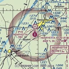
| Sectional chart |
|---|
|
| Airport distance calculator |
|---|
|
|
| Sunrise and sunset |
|---|
|
Times for 16-Jul-2026
| | Local
(UTC-5) | | Zulu
(UTC) |
|---|
| Morning civil twilight | | 05:53 | | 10:53 |
| Sunrise | | 06:22 | | 11:22 |
| Sunset | | 20:38 | | 01:38 |
| Evening civil twilight | | 21:07 | | 02:07 |
|
| Current date and time |
|---|
| Zulu (UTC) | 16-Jul-2026 17:51:09 |
|---|
| Local (UTC-5) | 16-Jul-2026 12:51:09 |
|---|
|
| METAR |
|---|
KOKM
16nm N | 161735Z AUTO 22006KT 10SM SCT034 SCT042 30/22 A3013 RMK AO2 T03010216
|
|
| TAF |
|---|
KMLC
33nm S | 161120Z 1612/1712 VRB03KT P6SM SCT100 SCT250 FM161600 20006KT P6SM SCT040 SCT120 PROB30 1618/1624 VRB15G25KT 5SM -TSRA BKN040CB FM170100 VRB03KT P6SM BKN250
|
KRVS
39nm N | 161120Z 1612/1712 VRB03KT P6SM SCT100 BKN200 FM161500 19011KT P6SM SCT040 SCT100 PROB30 1621/1701 VRB15G25KT 5SM -TSRA BKN040CB FM170100 17002KT P6SM BKN250
|
|
| NOTAMs |
|---|
NOTAMs are issued by the DoD/FAA and will open in a separate window not controlled by AirNav.
|
|

