FAA INFORMATION EFFECTIVE 14 MAY 2026
Location
| FAA Identifier: | RVS |
| Lat/Long: | 36-02-22.5030N 095-59-04.5410W
36-02.375050N 095-59.075683W
36.0395842,-95.9845947
(estimated) |
| Elevation: | 638.2 ft. / 194.5 m (surveyed) |
| Variation: | 03E (2020) |
| From city: | 5 miles S of TULSA, OK |
| Time zone: | UTC -5 (UTC -6 during Standard Time) |
| Zip code: | 74132 |
Airport Operations
| Airport use: | Open to the public |
| Activation date: | 07/1958 |
| Control tower: | yes |
| ARTCC: | KANSAS CITY CENTER |
| FSS: | MC ALESTER FLIGHT SERVICE STATION |
| NOTAMs facility: | RVS (NOTAM-D service available) |
| Attendance: | 0600 - 2200
AFT HR PPR. |
| Wind indicator: | lighted |
| Segmented circle: | yes |
| Lights: | WHEN ATCT CLSD ACTVT MIRL RWY 01R/19L & 13/31; HIRL RWY 01L/19R; TWY H, L, T & Z; TXL DD - CTAF. HIRL RWY 01L/19R PRESET MED INTST; INCR INTST - CTAF. |
| Beacon: | white-green (lighted land airport)
Operates sunset to sunrise. |
Airport Communications
| CTAF: | 120.3 |
| UNICOM: | 122.95 |
| ATIS: | 126.5 |
| WX ASOS: | 126.5 (918-299-0740) |
| RIVERSIDE GROUND: | 121.7 [0700-2200] |
| RIVERSIDE TOWER: | 120.3 119.2 [0700-2200] |
| TULSA APPROACH: | 119.85 ;356-174 134.7 ;175-355 |
| TULSA DEPARTURE: | 119.85 ;356-174 134.7 ;175-355 |
| CLEARANCE DELIVERY: | 124.5 |
| PRE-TAXI CLEARANCE: | 124.5 |
| IC: | 134.7 ;175-355 |
| TULSA DP: | 124.0 |
| VINTA STAR: | 119.1 |
| WX ASOS at TUL (11 nm NE): | PHONE 539-399-0187 |
| WX AWOS-3T at OWP (11 nm NW): | 118.325 (918-246-2635) |
- ONLY USE 119.2 LCL/TWR FREQUENCY WHEN ADVISED TO DO SO BY RVS ATC OR WHEN BROADCASTED ON RVS ATIS.
- SAID IN USE. OPERATE TRANSPONDERS WITH ALTITUDE REPORTING MODE AND ADS-B (IF EQUIPPED) ENABLED ON ALL AIRPORT SURFACES.
- USE AS PRI LCL/TWR FREQ ONLY WHEN ADZD BY ATIS OR ATC.
Nearby radio navigation aids
| VOR radial/distance | | VOR name | | Freq | | Var |
|---|
| TULr217/13.4 | | TULSA VORTAC | | 114.40 | | 08E |
| OKMr336/21.6 | | OKMULGEE VOR/DME | | 114.90 | | 08E |
| NDB name | | Hdg/Dist | | Freq | | Var | | ID |
|---|
| OILLR | | 230/5.8 | | 338 | | 03E | | TU | - ..- |
| HENRYETTA | | 358/38.1 | | 267 | | 04E | | HET | .... . - |
Airport Services
| Fuel available: | 100LL JET-A JET-A+ |
| Parking: | hangars and tiedowns |
| Airframe service: | MAJOR |
| Powerplant service: | MAJOR |
| Bottled oxygen: | LOW |
Runway Information
Runway 1L/19R
| Dimensions: | 5101 x 100 ft. / 1555 x 30 m |
| Surface: | asphalt/grooved, in good condition
ONLY CNTR 80 FT GRVD. |
| Weight bearing capacity: | | PCN 27 /F/B/X/T | | Single wheel: | 61.0 | | Double wheel: | 87.0 | | Double tandem: | 168.0 |
|
| Runway edge lights: | high intensity |
| RUNWAY 1L | | RUNWAY 19R |
| Latitude: | 36-01.980742N | | 36-02.798715N |
| Longitude: | 095-59.272295W | | 095-59.033515W |
| Elevation: | 621.9 ft. | | 638.2 ft. |
| Traffic pattern: | left | | right |
| Runway heading: | 010 magnetic, 013 true | | 190 magnetic, 193 true |
| Markings: | precision, in good condition | | nonprecision, in good condition |
| Visual slope indicator: | 4-light PAPI on left (3.00 degrees glide path) | | 4-light PAPI on left (3.20 degrees glide path) |
| Runway end identifier lights: | yes | | yes |
| Touchdown point: | yes, no lights | | yes, no lights |
| Instrument approach: | ILS/DME | | |
| Obstructions: | 31 ft. trees, 1450 ft. from runway, 40:1 slope to clear | | 36 ft. trees, 1076 ft. from runway, 151 ft. left of centerline, 24:1 slope to clear |
Runway 1R/19L
| Dimensions: | 4205 x 100 ft. / 1282 x 30 m |
| Surface: | asphalt, in good condition |
| Weight bearing capacity: | | Single wheel: | 30.0 | | Double wheel: | 60.0 |
|
| Runway edge lights: | medium intensity |
| RUNWAY 1R | | RUNWAY 19L |
| Latitude: | 36-02.041365N | | 36-02.715775N |
| Longitude: | 095-59.108582W | | 095-58.911683W |
| Elevation: | 619.2 ft. | | 630.2 ft. |
| Traffic pattern: | right | | left |
| Runway heading: | 010 magnetic, 013 true | | 190 magnetic, 193 true |
| Displaced threshold: | no | | 142 ft. |
| Markings: | basic, in good condition | | basic, in good condition |
| Visual slope indicator: | 4-light PAPI on left (2.83 degrees glide path) | | 4-light PAPI on left (2.83 degrees glide path) |
| Touchdown point: | yes, no lights | | yes, no lights |
| Obstructions: | none
48 FT PLINE 826 FT FM RWY 19L END CREATES 20:1 APCH CLNC SLP TO DTHR. | | 48 ft. pline, 826 ft. from runway, 13:1 slope to clear
8 FT ROAD 200 FT FM RWY THR, BOTH SIDES. |
Runway 13/31
| Dimensions: | 2639 x 50 ft. / 804 x 15 m |
| Surface: | asphalt, in fair condition |
| Weight bearing capacity: | |
| Runway edge lights: | medium intensity |
| RUNWAY 13 | | RUNWAY 31 |
| Latitude: | 36-02.489513N | | 36-02.192633N |
| Longitude: | 095-59.226567W | | 095-58.835207W |
| Elevation: | 624.4 ft. | | 614.8 ft. |
| Traffic pattern: | left | | right |
| Runway heading: | 130 magnetic, 133 true | | 310 magnetic, 313 true |
| Markings: | basic, in good condition | | basic, in good condition |
| Touchdown point: | yes, no lights | | yes, no lights |
| Obstructions: | 71 ft. trees, 1329 ft. from runway, 15:1 slope to clear | | none |
Airport Ownership and Management from official FAA records
| Ownership: | Publicly-owned |
| Owner: | CITY OF TULSA
TULSA ARPT IMPROVEMENT TRUST
BOX 581838 TULSA, OK 74158
Phone 918-838-5000 |
| Manager: | AUSTIN WHEELER
8303 S. HANGAR RD.
TULSA, OK 74132
Phone 918-299-5886 |
Additional Remarks
| A30A-13 | L TURN ON DEP BFR 1500 FT MSL NA. |
| A30A-31 | MNTN TPA UNTIL ABEAM AER ON DOWNWIND LEG. |
| - | NE, NW & SW RAMPS, PTNS OF TXL CC, DD & GG NOT VSB FM ATCT. |
| - | NOISE ABATEMENT: TURNS ON DEP PRIOR TO 1500 FT MSL NA. |
| - | BIRDS ON & INVOF ARPT. |
| - | TXL BB & NW PVT HNGR AREA TXL 20 FT WIDE. |
| - | NE & NW PVT HNGR AREA WINGSPAN GTR THAN 49 FT NA; TXL WT LMT 12500 LB. |
Instrument Procedures
NOTE: All procedures below are presented as PDF files. If you need a reader for these files, you should download the free Adobe Reader.NOT FOR NAVIGATION. Please procure official charts for flight.
FAA instrument procedures published for use from 14 May 2026 at 0901Z to 11 June 2026 at 0900Z.
STARs - Standard Terminal Arrivals |
|---|
| VINTA THREE | |
download (175KB) |
IAPs - Instrument Approach Procedures |
|---|
| ILS OR LOC RWY 01L **CHANGED** | |
download (286KB) |
| RNAV (GPS) RWY 01L **CHANGED** | |
download (261KB) |
| RNAV (GPS) RWY 19R **CHANGED** | |
download (247KB) |
| VOR/DME-A **CHANGED** | |
download (241KB) |
| NOTE: Special Alternate Minimums apply | |
download (145KB) |
Departure Procedures |
|---|
| TULSA ONE | |
download (230KB) |
| NOTE: Special Take-Off Minimums/Departure Procedures apply | |
download (378KB) |
Other nearby airports with instrument procedures:
KTUL - Tulsa International Airport (11 nm NE)
KOWP - William R Pogue Municipal Airport (11 nm NW)
KOKM - Okmulgee Regional Airport/Paul and Betty Abbott Field (22 nm S)
3F7 - Jones Memorial Airport (25 nm SW)
KGCM - Claremore Regional Airport (29 nm NE)
|
|

Road maps at:
MapQuest
Bing
Google
| Aerial photo |
|---|
WARNING: Photo may not be current or correct
 Photo by Tanner Price
Photo taken 09-Apr-2014
looking northwest.
Photo by Tanner Price
Photo taken 09-Apr-2014
looking northwest.
Do you have a better or more recent aerial photo of Tulsa Riverside Airport that you would like to share? If so, please send us your photo.
|
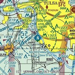
| Sectional chart |
|---|
|
CAUTION: Diagram may not be current
 Download PDF
of official airport diagram from the FAA
| Airport distance calculator |
|---|
|
|
| Sunrise and sunset |
|---|
|
Times for 05-Jun-2026
| | Local
(UTC-5) | | Zulu
(UTC) |
|---|
| Morning civil twilight | | 05:38 | | 10:38 |
| Sunrise | | 06:08 | | 11:08 |
| Sunset | | 20:37 | | 01:37 |
| Evening civil twilight | | 21:06 | | 02:06 |
|
| Current date and time |
|---|
| Zulu (UTC) | 05-Jun-2026 18:41:26 |
|---|
| Local (UTC-5) | 05-Jun-2026 13:41:26 |
|---|
|
| METAR |
|---|
| KRVS | 051753Z 22006KT 10SM FEW026 SCT032 29/23 A2994 RMK AO2 SLP141 T02890228 10294 20239 58006
|
KTUL
11nm NE | 051753Z 18007KT 10SM BKN028 BKN041 BKN200 29/22 A2995 RMK AO2 SLP132 T02890217 10294 20233 58007
|
|
| TAF |
|---|
| KRVS | 051737Z 0518/0618 18010G18KT P6SM SCT025 BKN040 FM052300 17008KT P6SM FEW050 BKN150 FM060900 16007KT P6SM VCSH OVC015 FM061200 17007KT 5SM -SHRA OVC015 TEMPO 0614/0618 3SM TSRA BR BKN009CB
|
KTUL
11nm NE | 051737Z 0518/0618 18011KT P6SM BKN025 FM051900 18011G19KT P6SM SCT025 BKN040 FM060100 16009KT P6SM FEW050 BKN150 FM060900 16007KT P6SM VCSH OVC015 FM061200 17008KT 5SM -SHRA OVC015 TEMPO 0614/0618 3SM TSRA BR BKN009CB
|
|
| NOTAMs |
|---|
NOTAMs are issued by the DoD/FAA and will open in a separate window not controlled by AirNav.
|
|


