FAA INFORMATION EFFECTIVE 11 JUNE 2026
Location
| FAA Identifier: | I06 |
| Lat/Long: | 34-34-00.5690N 101-46-53.2600W
34-34.009483N 101-46.887667W
34.5668247,-101.7814611
(estimated) |
| Elevation: | 3503 ft. / 1067.7 m (surveyed) |
| Variation: | 09E (1985) |
| From city: | 2 miles NW of TULIA, TX |
| Time zone: | UTC -5 (UTC -6 during Standard Time) |
| Zip code: | 79088 |
Airport Operations
| Airport use: | Open to the public |
| Activation date: | 03/1945 |
| Control tower: | no |
| ARTCC: | FORT WORTH CENTER |
| FSS: | FORT WORTH FLIGHT SERVICE STATION |
| NOTAMs facility: | FTW (NOTAM-D service available) |
| Attendance: | INTMNT |
| Wind indicator: | lighted |
| Segmented circle: | yes |
| Lights: | MIRL RWY 01/19 PRESET LOW INTST; TO INCR INTST ACTVT - 122.8. |
| Beacon: | white-green (lighted land airport)
Operates sunset to sunrise. |
Airport Communications
Nearby radio navigation aids
| VOR radial/distance | | VOR name | | Freq | | Var |
|---|
| PVWr350/28.8 | | PLAINVIEW VOR/DME | | 112.90 | | 11E |
Airport Services
| Fuel available: | 100LL
100LL:FUEL SELF SERVE. FOR ASSISTANCE CALL 806-995-3504 DURING REG. BUS. HRS. |
| Parking: | tiedowns |
| Bottled oxygen: | NONE |
| Bulk oxygen: | NONE |
Runway Information
Runway 1/19
| Dimensions: | 4876 x 60 ft. / 1486 x 18 m |
| Surface: | asphalt, in excellent condition |
| Weight bearing capacity: | |
| Runway edge lights: | medium intensity |
| RUNWAY 1 | | RUNWAY 19 |
| Latitude: | 34-33.618650N | | 34-34.400300N |
| Longitude: | 101-47.001000W | | 101-46.774333W |
| Elevation: | 3487.7 ft. | | 3502.9 ft. |
| Traffic pattern: | left | | left |
| Markings: | nonprecision, in good condition | | nonprecision, in good condition |
| Touchdown point: | yes, no lights | | yes, no lights |
| Obstructions: | 15 ft. road, 550 ft. from runway, 160 ft. both sides of centerline, 23:1 slope to clear | | none |
Airport Ownership and Management from official FAA records
| Ownership: | Publicly-owned |
| Owner: | CITY OF TULIA & SWISHER COUNTY
CITY HALL, 127 S.W. 2ND
TULIA, TX 79088
Phone 806-995-3547 |
| Manager: | MICHAEL CLAWSON, CO. JUDGE
SWISHER CO. COURTHOUSE, 119 S. MAXWELL
TULIA, TX 79088
Phone 806-786-2773
ADD'L CONTACTS: B.J. POTTS, CITY MGR, 806-995-3547; DOUG BARNES, A&P, 806-786-2773. |
Additional Remarks
| - | LIVESTOCK INVOF ARPT. |
| - | FOR CD CTC FORT WORTH ARTCC AT 817-858-7584. |
Instrument Procedures
There are no published instrument procedures at I06.
Some nearby airports with instrument procedures:
KPVW - Hale County Airport (24 nm S)
KHRX - Hereford Municipal Airport (32 nm NW)
KTDW - Tradewind Airport (36 nm N)
KAMA - Rick Husband Amarillo International Airport (39 nm N)
41F - Floydada Municipal Airport (41 nm SE)
|
|

Road maps at:
MapQuest
Bing
Google
| Aerial photo |
|---|
WARNING: Photo may not be current or correct
 Photo taken 26-May-2004
Do you have a better or more recent aerial photo of City of Tulia/Swisher County Municipal Airport that you would like to share? If so, please send us your photo.
|
| Sectional chart |
|---|
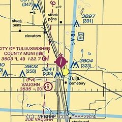
|
| Airport distance calculator |
|---|
|
|
| Sunrise and sunset |
|---|
|
Times for 14-Jun-2026
| | Local
(UTC-5) | | Zulu
(UTC) |
|---|
| Morning civil twilight | | 06:05 | | 11:05 |
| Sunrise | | 06:35 | | 11:35 |
| Sunset | | 21:00 | | 02:00 |
| Evening civil twilight | | 21:29 | | 02:29 |
|
| Current date and time |
|---|
| Zulu (UTC) | 14-Jun-2026 07:44:59 |
|---|
| Local (UTC-5) | 14-Jun-2026 02:44:59 |
|---|
|
| METAR |
|---|
KPVW
24nm S | 140710Z AUTO 30014KT 10SM VCTS BKN075 BKN085 24/16 A3007 RMK AO2 LTG DSNT NW THRU NE T02350155
|
KHRX
32nm NW | 140735Z AUTO 06013KT 10SM CLR 21/17 A3012 RMK AO2 T02140170 TSNO
|
KAMA
39nm N | 140731Z AUTO 05020G33KT 10SM VCTS OVC015 18/16 A3014 RMK AO2 PK WND 05033/0726 RAE0658 P0000 T01830161 $
|
|
| TAF |
|---|
KPVW
24nm S | 140520Z 1406/1506 01011KT P6SM SCT050 BKN250 FM140700 02015G25KT P6SM VCTS BKN050CB BKN250 FM141100 04016KT P6SM -SHRA SCT007 OVC015 PROB30 1411/1415 4SM TSRA BKN020CB FM142000 05011KT P6SM SCT007 OVC015 AMD NOT SKED
|
|
| NOTAMs |
|---|
NOTAMs are issued by the DoD/FAA and will open in a separate window not controlled by AirNav.
|
|


