FAA INFORMATION EFFECTIVE 07 AUGUST 2025
Location
| FAA Identifier: | K07 |
| Lat/Long: | 37-56-08.3480N 091-48-48.7710W
37-56.139133N 091-48.812850W
37.9356522,-91.8135475
(estimated) |
| Elevation: | 987 ft. / 300.8 m (surveyed) |
| Variation: | 05E (1975) |
| From city: | 3 miles SW of ROLLA, MO |
| Time zone: | UTC -5 (UTC -6 during Standard Time) |
| Zip code: | 65401 |
Airport Operations
| Airport use: | Open to the public |
| Activation date: | 10/1963 |
| Control tower: | no |
| ARTCC: | KANSAS CITY CENTER |
| FSS: | COLUMBIA FLIGHT SERVICE STATION |
| NOTAMs facility: | COU (NOTAM-D service available) |
| Attendance: | UNATNDD |
| Wind indicator: | yes |
| Segmented circle: | no |
Airport Communications
| CTAF/UNICOM: | 122.8 |
| WX ASOS at VIH (12 nm N): | 119.025 (573-299-4419) |
| WX ASOS at TBN (19 nm SW): | 118.7 |
- UNICOM UNMON.
- APCH/DEP SVC PRVDD BY KANSAS CITY ARTCC ON FREQS 128.35/284.675 (MAPLES RCAG).
Nearby radio navigation aids
| VOR radial/distance | | VOR name | | Freq | | Var |
|---|
| VIHr195/14.0 | | VICHY VOR/DME | | 117.70 | | 06E |
| TBNr053/(19.3) | | FORNEY VOR | | 110.00 | | 00E |
| SHYr100/37.8 | | SUNSHINE VOR/DME | | 108.40 | | 00E |
Airport Services
| Parking: | tiedowns |
| Bottled oxygen: | NONE |
| Bulk oxygen: | NONE |
Runway Information
Runway 9/27
| Dimensions: | 3028 x 38 ft. / 923 x 12 m |
| Surface: | asphalt, in good condition
RWY 9/27 PAVEMENT CRACKING, VEGETATION GROWING IN CRACKS. |
| Runway edge markings: | MARKINGS FADED.
NSTD BSC MARKNGS; INCORRECT LENGTH; WIDTH; COLOR & SPACING OF DSPLCD THLD & DESIGNATION MARKINGS RY 27. |
| RUNWAY 9 | | RUNWAY 27 |
| Latitude: | 37-56.153800N | | 37-56.125500N |
| Longitude: | 091-49.126783W | | 091-48.497867W |
| Elevation: | 956.0 ft. | | 964.0 ft. |
| Traffic pattern: | left | | left |
| Runway heading: | 088 magnetic, 093 true | | 268 magnetic, 273 true |
| Displaced threshold: | no | | 445 ft. |
| Markings: | NSTD, in poor condition | | NSTD, in poor condition |
| Touchdown point: | yes, no lights | | yes, no lights |
| Obstructions: | 28 ft. trees, 600 ft. from runway, 117 ft. right of centerline, 14:1 slope to clear
RWY 09 20-25 FT TREES, BRUSH 0-30 FT FM RWY END, 70 FT RIGHT. | | 55 ft. trees, 200 ft. from runway, 125 ft. left and right of centerline
RWY 27 1-55 FT TREES; FENCES; POWERLINES; BRUSHES & HIGH GND 0-200 FT FM RWY END LEFT & RIGHT. |
Airport Ownership and Management from official FAA records
| Ownership: | Privately-owned |
| Owner: | MAXINE DICKMAN FOSMARK
P.O. BOX 925
ROLLA, MO 65402
Phone 573-430-3065 |
| Manager: | MAXINE DICKMAN FOSMARK
P.O. BOX 925
ROLLA, MO 65402
Phone 573-430-3065 |
Additional Remarks
| - | WILDLIFE ON & INVOF ARPT. |
| - | RY 09/27 LINE OF SIGHT OBSTRUCTED BY GRADE CHANGE IN RY. |
| - | TALL BRUSH LOCATED 70-125 FT SOUTH OF RY, FM RY 09 THLD TO ACCESS TWY. |
| - | FOR CD CTC KANSAS CITY ARTCC AT 913-254-8508. |
Instrument Procedures
There are no published instrument procedures at K07.
Some nearby airports with instrument procedures:
KVIH - Rolla National Airport (12 nm N)
KTBN - Waynesville-St. Robert Regional Airport-Forney Field (19 nm SW)
KUBX - Cuba Municipal Airport (20 nm NE)
K33 - Salem Memorial Airport (22 nm SE)
KUUV - Sullivan Regional Airport (35 nm NE)
|
|

Road maps at:
MapQuest
Bing
Google
| Aerial photo |
|---|
WARNING: Photo may not be current or correct

Do you have a better or more recent aerial photo of Rolla Downtown Airport that you would like to share? If so, please send us your photo.
|
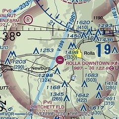
| Sectional chart |
|---|
|
| Airport distance calculator |
|---|
|
|
| Sunrise and sunset |
|---|
|
Times for 18-Aug-2025
| | Local
(UTC-5) | | Zulu
(UTC) |
|---|
| Morning civil twilight | | 05:58 | | 10:58 |
| Sunrise | | 06:26 | | 11:26 |
| Sunset | | 19:56 | | 00:56 |
| Evening civil twilight | | 20:24 | | 01:24 |
|
| Current date and time |
|---|
| Zulu (UTC) | 18-Aug-2025 11:45:23 |
|---|
| Local (UTC-5) | 18-Aug-2025 06:45:23 |
|---|
|
| METAR |
|---|
KVIH
12nm N | 181053Z AUTO 15009KT 10SM CLR 23/21 A3002 RMK AO2 SLP155 T02330211 $
|
KTBN
19nm SW | 181055Z AUTO 15004KT 10SM CLR 23/21 A2999 RMK AO2 SLP147 T02260214 $
|
|
| NOTAMs |
|---|
NOTAMs are issued by the DoD/FAA and will open in a separate window not controlled by AirNav.
|
|

