FAA INFORMATION EFFECTIVE 09 JULY 2026
Location
| FAA Identifier: | ABI |
| Lat/Long: | 32-24-40.8000N 099-40-54.8000W
32-24.680000N 099-40.913333W
32.4113333,-99.6818889
(estimated) |
| Elevation: | 1790.6 ft. / 545.8 m (surveyed) |
| Variation: | 05E (2020) |
| From city: | 3 miles SE of ABILENE, TX |
| Time zone: | UTC -5 (UTC -6 during Standard Time) |
| Zip code: | 79602 |
Airport Operations
| Airport use: | Open to the public |
| Activation date: | 11/1953 |
| Control tower: | yes |
| ARTCC: | FORT WORTH CENTER |
| FSS: | FORT WORTH FLIGHT SERVICE STATION |
| NOTAMs facility: | ABI (NOTAM-D service available) |
| Attendance: | CONTINUOUS |
| Wind indicator: | lighted |
| Segmented circle: | yes |
| Lights: | SS-SR |
| Beacon: | white-green (lighted land airport)
Operates sunset to sunrise. |
| Fire and rescue: | ARFF index B |
| Airline operations: | ABI IS ARFF INDEX B; ARFF INDEX C AVBL WITH PPR. |
Airport Communications
| UNICOM: | 122.95 |
| ATIS: | 118.25 |
| WX ASOS: | PHONE 325-238-3987 |
| ABILENE GROUND: | 121.7 348.6 |
| ABILENE TOWER: | 120.1 257.8 |
| ABILENE APPROACH: | 125.0 ;EAST 127.2 ;WEST 282.3 ;WEST 338.3 ;EAST |
| ABILENE DEPARTURE: | 125.0 ;EAST 127.2 ;WEST 282.3 ;WEST 338.3 ;EAST |
| CLASS C: | 125.0 ;EAST 127.2 ;WEST 282.3 ;WEST 338.3 ;EAST |
| EMERG: | 121.5 243.0 |
| WX ASOS at DYS (9 nm W): | 269.175 |
Nearby radio navigation aids
| VOR radial/distance | | VOR name | | Freq | | Var |
|---|
| ABIr105/10.1 | | ABILENE VORTAC | | 113.70 | | 10E |
| TQAr023/12.6 | | TUSCOLA VOR/DME | | 114.85 | | 10E |
| NDB name | | Hdg/Dist | | Freq | | Var | | ID |
|---|
| TOMHI | | 352/6.8 | | 353 | | 05E | | AB | .- -... |
Airport Services
| Fuel available: | 100LL JET-A |
| Parking: | hangars and tiedowns |
| Airframe service: | MAJOR |
| Powerplant service: | MAJOR |
| Bottled oxygen: | NONE |
| Bulk oxygen: | HIGH/LOW |
Runway Information
Runway 17R/35L
| Dimensions: | 7208 x 150 ft. / 2197 x 46 m |
| Surface: | asphalt/grooved, in good condition |
| Weight bearing capacity: | | Single wheel: | 120.0 | | Double wheel: | 218.0 | | Double tandem: | 289.0 | | Dual double tandem: | 768.0 |
|
| Runway edge lights: | high intensity |
| RUNWAY 17R | | RUNWAY 35L |
| Latitude: | 32-25.685050N | | 32-24.496390N |
| Longitude: | 099-41.095163W | | 099-41.089260W |
| Elevation: | 1758.4 ft. | | 1786.1 ft. |
| Traffic pattern: | right | | left |
| Runway heading: | 175 magnetic, 180 true | | 355 magnetic, 360 true |
| Declared distances: | TORA:7202 TODA:7202 ASDA:7202 LDA:7202 | | TORA:7202 TODA:7202 ASDA:7202 LDA:7202 |
| Markings: | nonprecision, in good condition | | nonprecision, in good condition |
| Visual slope indicator: | 4-light PAPI on left (3.00 degrees glide path) | | 4-light PAPI on left (3.00 degrees glide path) |
| Runway end identifier lights: | | | yes |
| Touchdown point: | yes, no lights | | yes, no lights |
| Instrument approach: | LOC/DME | | |
Runway 17L/35R
| Dimensions: | 7198 x 150 ft. / 2194 x 46 m |
| Surface: | asphalt/grooved, in good condition |
| Weight bearing capacity: | | Single wheel: | 120.0 | | Double wheel: | 194.0 | | Double tandem: | 259.0 | | Dual double tandem: | 715.0 |
|
| Runway edge lights: | high intensity |
| RUNWAY 17L | | RUNWAY 35R |
| Latitude: | 32-24.511877N | | 32-23.324885N |
| Longitude: | 099-40.486822W | | 099-40.480982W |
| Elevation: | 1790.6 ft. | | 1775.9 ft. |
| Traffic pattern: | left | | right |
| Runway heading: | 175 magnetic, 180 true | | 355 magnetic, 360 true |
| Declared distances: | TORA:7198 TODA:7198 ASDA:7198 LDA:7198 | | TORA:7198 TODA:7198 ASDA:7198 LDA:7198 |
| Markings: | precision, in good condition | | precision, in good condition |
| Visual slope indicator: | 4-light PAPI on left (3.00 degrees glide path) | | |
| RVR equipment: | rollout | | touchdown |
| Approach lights: | | | MALSR: 1,400 foot medium intensity approach lighting system with runway alignment indicator lights |
| Touchdown point: | yes, no lights | | yes, no lights |
| Instrument approach: | | | ILS/DME |
| Obstructions: | 2 ft. gnd, 200 ft. from runway | | none |
Airport Ownership and Management from official FAA records
| Ownership: | Publicly-owned |
| Owner: | CITY OF ABILENE
PO BOX 60
ABILENE, TX 79604
Phone 325-676-6206 |
| Manager: | DON GREEN
2933 AIRPORT BLVD SUITE 200
ABILENE, TX 79602
Phone 325-676-6367 |
Additional Remarks
| A39-17L/35R | PCR VALUE: 600/F/D/W/T |
| A39-17R/35L | PCR VALUE: 680/F/D/W/T |
| - | UNCTLD ARPT 2 NM NE OF ARPT, PAT ALT 2300 FT. |
| - | MIL AVN SVCS AVBL AT ARPT. |
| - | HIGH BIRD ACTVTY ON AND INVOF ARPT. |
Instrument Procedures
NOTE: All procedures below are presented as PDF files. If you need a reader for these files, you should download the free Adobe Reader.NOT FOR NAVIGATION. Please procure official charts for flight.
FAA instrument procedures published for use from 09 July 2026 at 0901Z to 06 August 2026 at 0900Z.
IAPs - Instrument Approach Procedures |
|---|
| ILS OR LOC RWY 35R **CHANGED** | |
download (275KB) |
| RNAV (GPS) RWY 17L **CHANGED** | |
download (198KB) |
| RNAV (GPS) RWY 35R **CHANGED** | |
download (229KB) |
| LOC RWY 17R **CHANGED** | |
download (234KB) |
| NOTE: Special Alternate Minimums apply **CHANGED** | |
download (139KB) |
| NOTE: Special Take-Off Minimums/Departure Procedures apply | |
download (299KB) |
Other nearby airports with instrument procedures:
KDYS - Dyess Air Force Base (9 nm W)
T23 - Albany Municipal Airport (28 nm NE)
F56 - Arledge Field Airport (30 nm N)
77F - Winters Municipal Airport (32 nm SW)
KGZN - Gregory M Simmons Memorial Airport (33 nm E)
|
|

Road maps at:
MapQuest
Bing
Google
| Aerial photo |
|---|
WARNING: Photo may not be current or correct
 Photo by Jeff Randall
Photo taken 17-Feb-2010
from 12,000 ft.
Photo by Jeff Randall
Photo taken 17-Feb-2010
from 12,000 ft.
Do you have a better or more recent aerial photo of Abilene Regional Airport that you would like to share? If so, please send us your photo.
|
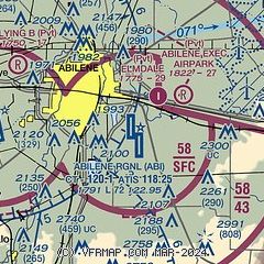
| Sectional chart |
|---|
|
CAUTION: Diagram may not be current
 Download PDF
of official airport diagram from the FAA
| Airport distance calculator |
|---|
|
|
| Sunrise and sunset |
|---|
|
Times for 13-Jul-2026
| | Local
(UTC-5) | | Zulu
(UTC) |
|---|
| Morning civil twilight | | 06:14 | | 11:14 |
| Sunrise | | 06:42 | | 11:42 |
| Sunset | | 20:47 | | 01:47 |
| Evening civil twilight | | 21:15 | | 02:15 |
|
| Current date and time |
|---|
| Zulu (UTC) | 13-Jul-2026 17:38:48 |
|---|
| Local (UTC-5) | 13-Jul-2026 12:38:48 |
|---|
|
| METAR |
|---|
| KABI | 131652Z 10SM FEW030 31/23 A3016 RMK AO2 LTG DSNT SE AND W SLP185 T03060228
|
KDYS
8nm W | 131655Z AUTO 03008KT 10SM -VCTSRA FEW030 29/21 A3013 RMK AO2 LTG DSNT SE-S AND W RAB37E44 SLP177 P0000 T02910210
|
|
| TAF |
|---|
| KABI | 131149Z 1312/1412 14006KT P6SM BKN100 FM131700 01006KT P6SM BKN050 PROB30 1320/1324 5SM -TSRA BKN050CB FM140000 12007KT P6SM SCT100 BKN250
|
KDYS
8nm W | 131600Z 1316/1422 30009KT 9999 BKN060 QNH3004INS TEMPO 1316/1318 -DZ TEMPO 1323/1402 VRB15G25KT 8000 -TSRA BKN050CB BECMG 1401/1402 10012G18KT 9000 SHRA BKN050 QNH3006INS BECMG 1403/1404 VRB06KT 9999 NSW SCT030 QNH3005INS BECMG 1413/1414 VRB06KT 9999 BKN020 QNH3008INS BECMG 1418/1419 09012KT 9999 BKN030 QNH3001INS TEMPO 1419/1422 09012G18KT 9000 VCTS BKN030CB TX32/1322Z TN21/1412Z
|
|
| NOTAMs |
|---|
NOTAMs are issued by the DoD/FAA and will open in a separate window not controlled by AirNav.
|
|


