FAA INFORMATION EFFECTIVE 19 MARCH 2026
Location
| FAA Identifier: | ACV |
| Lat/Long: | 40-58-40.1750N 124-06-30.4890W
40-58.669583N 124-06.508150W
40.9778264,-124.1084692
(estimated) |
| Elevation: | 222.3 ft. / 67.8 m (surveyed) |
| Variation: | 17E (1985) |
| From city: | 7 miles N of central business district of the associated city |
| Time zone: | UTC -7 (UTC -8 during Standard Time) |
| Zip code: | 95519 |
Airport Operations
| Airport use: | Open to the public |
| Activation date: | 03/1943 |
| Control tower: | no |
| ARTCC: | SEATTLE CENTER |
| FSS: | OAKLAND FLIGHT SERVICE STATION |
| NOTAMs facility: | ACV (NOTAM-D service available) |
| Attendance: | ALL 0400-2359 |
| Wind indicator: | lighted |
| Segmented circle: | yes |
| Lights: | ACTVT MALSR RWY 32; TDZL RWY 32; C/L LGTS RWY 14 & 32; REIL RWY 14; PAPI RWY 14 & 32; HIRL RWY 14/32 - CTAF. MIRL RWY 01/19, REIL RWY 01, AND VASI RWY 01 PPR CTC 707-382-2551 OR 707-496-0102. |
| Beacon: | white-green (lighted land airport)
Operates sunset to sunrise. |
| Landing fee: | yes, LNDG FEE: CTC ARPT OR CHECK ARPT WEBSITE FOR DTLS, EXEMPTIONS. |
| Fire and rescue: | ARFF index B |
Airport Communications
| CTAF/UNICOM: | 123.0 |
| WX ASOS: | 118.525 (707-839-7429) |
- APCH/DEP CTL SVC PRVDD BY SEATTLE ARTCC (ZSE) ON FREQS 124.85/306.3 (ARCATA RCAG).
Nearby radio navigation aids
| VOR radial/distance | | VOR name | | Freq | | Var |
|---|
| ACV at field | | ARCATA VOR/DME | | 115.05 | | 17E |
| FOTr358/19.3 | | FORTUNA VORTAC | | 114.00 | | 19E |
Airport Services
| Fuel available: | 100LL JET-A
100LL:FUEL AVBL 0400-2400 LOCAL, AND AFTER HOURS WITH ADVANCED NOTICE. |
| Parking: | tiedowns |
| Airframe service: | NONE |
| Powerplant service: | NONE |
| Bottled oxygen: | NONE |
| Bulk oxygen: | NONE |
Runway Information
Runway 14/32
| Dimensions: | 6046 x 150 ft. / 1843 x 46 m |
| Surface: | asphalt/grooved, in good condition |
| Weight bearing capacity: | | Single wheel: | 60.0 | | Double wheel: | 155.0 | | Double tandem: | 280.0 |
|
| Runway edge lights: | high intensity |
| RUNWAY 14 | | RUNWAY 32 |
| Latitude: | 40-59.116747N | | 40-58.231718N |
| Longitude: | 124-06.787423W | | 124-06.185797W |
| Elevation: | 182.9 ft. | | 222.3 ft. |
| Traffic pattern: | right | | left |
| Runway heading: | 136 magnetic, 153 true | | 316 magnetic, 333 true |
| Displaced threshold: | 245 ft. | | 200 ft. |
| Declared distances: | TORA:6046 TODA:6046 ASDA:5846 LDA:5601 | | TORA:6046 TODA:6046 ASDA:6046 LDA:5846 |
| Markings: | precision, in good condition | | precision, in good condition |
| Visual slope indicator: | 4-light PAPI on left (3.00 degrees glide path) | | 4-light PAPI on left (3.00 degrees glide path) |
| RVR equipment: | touchdown, rollout | | touchdown, rollout |
| Approach lights: | | | MALSR: 1,400 foot medium intensity approach lighting system with runway alignment indicator lights |
| Runway end identifier lights: | yes | | no |
| Centerline lights: | yes | | yes |
| Touchdown point: | yes, no lights | | yes, lighted |
| Instrument approach: | | | ILS/DME |
| Obstructions: | none | | 91 ft. tree, 2625 ft. from runway, 875 ft. right of centerline, 26:1 slope to clear |
Runway 1/19
| Dimensions: | 4501 x 150 ft. / 1372 x 46 m |
| Surface: | asphalt/grooved, in fair condition |
| Weight bearing capacity: | | Single wheel: | 60.0 | | Double wheel: | 95.0 | | Double tandem: | 170.0 |
|
| Runway edge lights: | medium intensity |
| Operational restrictions: | RWY 01/19 NOT AVBL FOR PART 121/PART 380 OPS WITH SKED PAX CARRYING OPS MORE THAN 9 PAX SEATS AND NON-SKED PAX CARRYING OPS MORE THAN 30 PAX SEATS. |
| RUNWAY 1 | | RUNWAY 19 |
| Latitude: | 40-58.341583N | | 40-58.985072N |
| Longitude: | 124-06.779680W | | 124-06.294535W |
| Elevation: | 187.4 ft. | | 208.3 ft. |
| Traffic pattern: | left | | right |
| Runway heading: | 013 magnetic, 030 true | | 193 magnetic, 210 true |
| Declared distances: | TORA:4501 TODA:4501 ASDA:4501 LDA:4501 | | TORA:4501 TODA:4501 ASDA:4501 LDA:4501 |
| Markings: | nonprecision, in fair condition | | nonprecision, in fair condition |
| Visual slope indicator: | 4-box VASI on left (3.00 degrees glide path) | | |
| Runway end identifier lights: | yes | | no |
| Touchdown point: | yes, no lights | | yes, no lights |
| Obstructions: | none | | 142 ft. trees, 3450 ft. from runway, 23:1 slope to clear |
Airport Ownership and Management from official FAA records
| Ownership: | Publicly-owned |
| Owner: | HUMBOLDT COUNTY
1106 SECOND ST
EUREKA, CA 95501
Phone (707) 496-0102 |
| Manager: | JUSTIN HOPMAN
3561 BOEING AVE.
MCKINLEYVILLE, CA 95519
Phone 707-382-2551
EMAIL: JHOPMAN@CO.HUMBOLDT.CA.US |
Additional Remarks
| A39-01/19 | PCR VALUE: 62/F/D/X/U |
| A39-14/32 | PCR VALUE: 530/F/D/X/T |
| E60-32 | ENGINEERED MATERIAL ARRESTING SYSTEM (EMAS) 280 FT IN LEN BY 170 FT IN WID STARTING 70 FT BYD DER 32. |
| - | FOR CD IF UNA TO CTC ON FSS FREQ, CTC SEATTLE ARTCC AT 253-351-3694. |
Instrument Procedures
NOTE: All procedures below are presented as PDF files. If you need a reader for these files, you should download the free Adobe Reader.NOT FOR NAVIGATION. Please procure official charts for flight.
FAA instrument procedures published for use from 19 March 2026 at 0901Z to 16 April 2026 at 0900Z.
IAPs - Instrument Approach Procedures |
|---|
| ILS OR LOC RWY 32 | |
download (713KB) |
| RNAV (GPS) RWY 01 | |
download (306KB) |
| RNAV (GPS) RWY 14 | |
download (299KB) |
| RNAV (GPS) RWY 32 | |
download (415KB) |
| NOTE: Special Alternate Minimums apply | |
download (498KB) |
Departure Procedures |
|---|
| HOCUT FIVE | |
download (186KB) |
| NOTE: Special Take-Off Minimums/Departure Procedures apply | |
download (837KB) |
Other nearby airports with instrument procedures:
KEKA - Murray Field Airport (10 nm S)
KFOT - Rohnerville Airport (25 nm S)
KCEC - Jack Mc Namara Field Airport (48 nm N)
KBOK - Brookings Airport (66 nm N)
O46 - Weed Airport (81 nm NE)
|
|

Road maps at:
MapQuest
Bing
Google
| Aerial photo |
|---|
WARNING: Photo may not be current or correct
 Photo by Srinath Nandakumar
Photo taken 08-Jul-2020
from the west of the field, looking east
Photo by Srinath Nandakumar
Photo taken 08-Jul-2020
from the west of the field, looking east
Do you have a better or more recent aerial photo of California Redwood Coast-Humboldt County Airport that you would like to share? If so, please send us your photo.
|
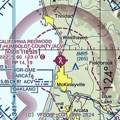
| Sectional chart |
|---|
|
| Airport distance calculator |
|---|
|
|
| Sunrise and sunset |
|---|
|
Times for 14-Apr-2026
| | Local
(UTC-7) | | Zulu
(UTC) |
|---|
| Morning civil twilight | | 06:11 | | 13:11 |
| Sunrise | | 06:40 | | 13:40 |
| Sunset | | 19:54 | | 02:54 |
| Evening civil twilight | | 20:22 | | 03:22 |
|
| Current date and time |
|---|
| Zulu (UTC) | 14-Apr-2026 15:55:51 |
|---|
| Local (UTC-7) | 14-Apr-2026 08:55:51 |
|---|
|
| METAR |
|---|
| KACV | 141453Z AUTO 00000KT 10SM OVC034 07/06 A3021 RMK AO2 SLP236 T00670056 53005
|
KFOT
20nm S | 141535Z AUTO 00000KT 10SM CLR 07/07 A3022 RMK AO1
|
|
| TAF |
|---|
| KACV | 141132Z 1412/1512 02003KT P6SM SCT025 TEMPO 1414/1418 FEW015 BKN025 FM141800 31006KT P6SM SCT025 FM142100 31010KT P6SM SCT050 BKN100 FM150300 34005KT P6SM OVC100 PROB30 1508/1512 P6SM -SHRA SCT025 OVC050
|
|
| NOTAMs |
|---|
NOTAMs are issued by the DoD/FAA and will open in a separate window not controlled by AirNav.
|
|

