FAA INFORMATION EFFECTIVE 11 JUNE 2026
Location
| FAA Identifier: | AIB |
| Lat/Long: | 38-14-20.4080N 108-33-46.1040W
38-14.340133N 108-33.768400W
38.2390022,-108.5628067
(estimated) |
| Elevation: | 5945.1 ft. / 1812.1 m (surveyed) |
| Variation: | 11E (2005) |
| From city: | 2 miles SW of NUCLA, CO |
| Time zone: | UTC -6 (UTC -7 during Standard Time) |
| Zip code: | 81422 |
Airport Operations
| Airport use: | Open to the public |
| Activation date: | 09/1946 |
| Control tower: | no |
| ARTCC: | DENVER CENTER |
| FSS: | DENVER FLIGHT SERVICE STATION |
| NOTAMs facility: | DEN (NOTAM-D service available) |
| Attendance: | UNATNDD |
| Wind indicator: | lighted |
| Segmented circle: | yes |
| Lights: | REIL RWY 05 & 23; MIRL RWY 5/23 - DUSK-DAWN, INCR INTST - CTAF. PAPI RWY 05 & 23 ON CONSLY. |
| Beacon: | white-green (lighted land airport)
Operates sunset to sunrise. |
Airport Communications
| CTAF/UNICOM: | 122.8 |
| WX AWOS-3P: | 132.525 (970-864-2325) |
- APCH/DEP CTL SVC PRVDD BY DENVER ARTCC (ZDV) ON FREQS 127.1(MONTROSE RCAG).
Nearby radio navigation aids
| VOR radial/distance | | VOR name | | Freq | | Var |
|---|
| ETLr298/18.7 | | CONES VOR/DME | | 116.95 | | 12E |
| DVCr020/31.1 | | DOVE CREEK VORTAC | | 114.60 | | 14E |
| MTJr231/35.1 | | MONTROSE VOR/DME | | 117.10 | | 12E |
Airport Services
| Fuel available: | 100LL JET-A
100LL:FUEL SELF-SERVICE AVBL 24 HRS. |
| Parking: | tiedowns |
| Bottled oxygen: | NONE |
| Bulk oxygen: | NONE |
Runway Information
Runway 5/23
| Dimensions: | 5212 x 75 ft. / 1589 x 23 m |
| Surface: | asphalt, in excellent condition |
| Weight bearing capacity: | |
| Runway edge lights: | medium intensity |
| RUNWAY 5 | | RUNWAY 23 |
| Latitude: | 38-14.130557N | | 38-14.578660N |
| Longitude: | 108-34.238738W | | 108-33.310425W |
| Elevation: | 5898.1 ft. | | 5945.1 ft. |
| Traffic pattern: | left | | left |
| Runway heading: | 048 magnetic, 059 true | | 228 magnetic, 239 true |
| Markings: | nonprecision, in fair condition | | nonprecision, in good condition |
| Visual slope indicator: | 2-light PAPI on left (3.00 degrees glide path)
PAPI UNUSBL BYD 5.0 NM. | | 2-light PAPI on left (3.00 degrees glide path) |
| Runway end identifier lights: | yes | | yes |
| Touchdown point: | yes, no lights | | yes, no lights |
| Obstructions: | none | | 18 ft. road, 570 ft. from runway, 20:1 slope to clear |
Runway 11/29
| Dimensions: | 4000 x 80 ft. / 1219 x 24 m |
| Surface: | turf/dirt, in poor condition
MULT LRG RODENT HOLES. |
| RUNWAY 11 | | RUNWAY 29 |
| Latitude: | 38-14.503518N | | 38-14.138957N |
| Longitude: | 108-34.108237W | | 108-33.412428W |
| Elevation: | 5899.4 ft. | | 5930.0 ft. |
| Traffic pattern: | left | | left |
| Runway heading: | 113 magnetic, 124 true | | 293 magnetic, 304 true |
| Markings: | NSTD, in good condition | | NSTD, in good condition |
| Touchdown point: | yes, no lights | | yes, no lights |
| Obstructions: | 6 ft. road, 100 ft. from runway, 16:1 slope to clear | | 3 ft. fence, 56 ft. from runway, 18:1 slope to clear |
Airport Ownership and Management from official FAA records
| Ownership: | Publicly-owned |
| Owner: | COUNTY OF MONTROSE
BOX 997
MONTROSE, CO 81401
Phone 970-249-3203 |
| Manager: | LLOYD ARNOLD
BOX 58
NUCLA, CO 81424
Phone 970-864-7111 |
Additional Remarks
| - | 40 FT PLINES IN HANGAR AREA. |
| - | MIGTATORY BIRDS, WILDLIFE & DEER ON OR INVOF ARPT. |
| - | FOR CD CTC DENVER ARTCC AT 303-651-4257. |
Instrument Procedures
NOTE: All procedures below are presented as PDF files. If you need a reader for these files, you should download the free Adobe Reader.NOT FOR NAVIGATION. Please procure official charts for flight.
FAA instrument procedures published for use from 11 June 2026 at 0901Z to 09 July 2026 at 0900z.
IAPs - Instrument Approach Procedures |
|---|
| RNAV (GPS)-A | |
download (172KB) |
| NOTE: Special Alternate Minimums apply | |
download (140KB) |
|
|---|
| NUCLA TWO (OBSTACLE) (RNAV) | |
download (240KB) |
| NOTE: Special Take-Off Minimums/Departure Procedures apply | |
download (289KB) |
Other nearby airports with instrument procedures:
KTEX - Telluride Regional Airport (35 nm SE)
KMTJ - Montrose Regional Airport (35 nm NE)
KAJZ - Blake Field Airport (40 nm NE)
U64 - Monticello Airport (41 nm SW)
KGJT - Grand Junction Regional Airport (53 nm N)
|
|

Road maps at:
MapQuest
Bing
Google
| Aerial photo |
|---|
WARNING: Photo may not be current or correct
 Photo by Mr. Richard Mowbray
Photo taken 28-Aug-2013
looking east.
Photo by Mr. Richard Mowbray
Photo taken 28-Aug-2013
looking east.
Do you have a better or more recent aerial photo of Hopkins Field Airport that you would like to share? If so, please send us your photo.
|
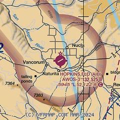
| Sectional chart |
|---|
|
| Airport distance calculator |
|---|
|
|
| Sunrise and sunset |
|---|
|
Times for 24-Jun-2026
| | Local
(UTC-6) | | Zulu
(UTC) |
|---|
| Morning civil twilight | | 05:21 | | 11:21 |
| Sunrise | | 05:53 | | 11:53 |
| Sunset | | 20:40 | | 02:40 |
| Evening civil twilight | | 21:12 | | 03:12 |
|
| Current date and time |
|---|
| Zulu (UTC) | 24-Jun-2026 17:35:09 |
|---|
| Local (UTC-6) | 24-Jun-2026 11:35:09 |
|---|
|
| METAR |
|---|
| KAIB | 241715Z AUTO 22014KT 10SM CLR 31/02 A3017 RMK AO2 T03090024
|
|
| TAF |
|---|
KMTJ
35nm NE | 241620Z 2416/2512 14008KT 4SM FU SCT200 TEMPO 2416/2418 2SM FU FM241800 24012G22KT 4SM FU FEW110 SCT150 FM250000 17013G24KT P6SM SCT080 BKN110 PROB30 2500/2504 6SM -TSRA BKN080CB FM250400 16012KT P6SM SCT070 BKN090 PROB30 2504/2510 6SM -SHRA OVC070
|
KTEX
36nm SE | 241140Z 2412/2512 15007KT 6SM FU SCT100 FM241800 23010G20KT P6SM SCT070 OVC100 PROB30 2421/2503 6SM -TSRA BKN070CB FM250300 16007KT P6SM SCT050 BKN070 PROB30 2503/2509 6SM -SHRA BKN050
|
|
| NOTAMs |
|---|
NOTAMs are issued by the DoD/FAA and will open in a separate window not controlled by AirNav.
|
|

