FAA INFORMATION EFFECTIVE 09 JULY 2026
Location
| FAA Identifier: | APY |
| Lat/Long: | 26-58-07.6300N 099-14-56.0700W
26-58.127167N 099-14.934500W
26.9687861,-99.2489083
(estimated) |
| Elevation: | 422.1 ft. / 128.7 m (surveyed) |
| Variation: | 08E (1985) |
| From city: | 4 miles NE of ZAPATA, TX |
| Time zone: | UTC -5 (UTC -6 during Standard Time) |
| Zip code: | 78076 |
Airport Operations
| Airport use: | Open to the public |
| Activation date: | 02/1987 |
| Control tower: | no |
| ARTCC: | HOUSTON CENTER |
| FSS: | SAN ANGELO FLIGHT SERVICE STATION |
| NOTAMs facility: | SJT (NOTAM-D service available) |
| Attendance: | IREG |
| Wind indicator: | lighted |
| Segmented circle: | yes |
| Lights: | DUSK-DAWN. MIRL RWY 12/30 PRESET MED INTST; TO INCR INTST ACTVT - CTAF. |
| Beacon: | white-green (lighted land airport)
Operates sunset to sunrise. |
Airport Communications
| CTAF/UNICOM: | 122.7 |
| WX AWOS-3: | 118.225 (956-765-4069) |
Nearby radio navigation aids
| VOR radial/distance | | VOR name | | Freq | | Var |
|---|
| LRDr155/31.9 | | LAREDO VORTAC | | 117.40 | | 09E |
Airport Services
| Fuel available: | 100LL JET-A |
| Parking: | hangars and tiedowns |
Runway Information
Runway 12/30
| Dimensions: | 5000 x 60 ft. / 1524 x 18 m |
| Surface: | asphalt, in good condition |
| Weight bearing capacity: | |
| Runway edge lights: | medium intensity |
| RUNWAY 12 | | RUNWAY 30 |
| Latitude: | 26-58.389100N | | 26-57.865050N |
| Longitude: | 099-15.290133W | | 099-14.578783W |
| Elevation: | 421.4 ft. | | 407.9 ft. |
| Traffic pattern: | left | | left |
| Runway heading: | 121 magnetic, 129 true | | 301 magnetic, 309 true |
| Displaced threshold: | 112 ft. | | 113 ft. |
| Markings: | nonprecision, in good condition | | nonprecision, in good condition |
| Touchdown point: | yes, no lights | | yes, no lights |
| Obstructions: | 18 ft. trees, 277 ft. from runway, 36 ft. right of centerline, 4:1 slope to clear
12 FT TREES, 190 FT DSTC,125 FT L/R. | | 20 ft. trees, 201 ft. from runway, 125 ft. left and right of centerline
20 FT TREES, 195 FT DSTC, 125 FT L/R. |
Airport Ownership and Management from official FAA records
| Ownership: | Publicly-owned |
| Owner: | ZAPATA COUNTY
PO BOX 760
ZAPATA, TX 78076
Phone 956-765-9920 |
| Manager: | DOMINGO CASTANEDA
246 AIRPORT RD, P O BOX 760
ZAPATA, TX 78076
Phone 956-334-5345 |
Additional Remarks
| - | FOR CD CTC HOUSTON ARTCC AT 281-230-5622. |
Instrument Procedures
There are no published instrument procedures at KAPY.
Some nearby airports with instrument procedures:
KHBV - Jim Hogg County Airport (36 nm NE)
KLRD - Laredo International Airport (36 nm N)
KBKS - Brooks County Airport (62 nm E)
KEBG - South Texas International Airport at Edinburg (68 nm SE)
KMFE - Mc Allen International Airport (72 nm SE)
|
|

Road maps at:
MapQuest
Bing
Google
| Aerial photo |
|---|
WARNING: Photo may not be current or correct
 looking northwest.
Do you have a better or more recent aerial photo of Zapata County Airport that you would like to share? If so, please send us your photo.
|
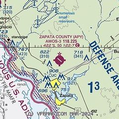
| Sectional chart |
|---|
|
| Airport distance calculator |
|---|
|
|
| Sunrise and sunset |
|---|
|
Times for 20-Jul-2026
| | Local
(UTC-5) | | Zulu
(UTC) |
|---|
| Morning civil twilight | | 06:30 | | 11:30 |
| Sunrise | | 06:56 | | 11:56 |
| Sunset | | 20:31 | | 01:31 |
| Evening civil twilight | | 20:56 | | 01:56 |
|
| Current date and time |
|---|
| Zulu (UTC) | 20-Jul-2026 07:25:09 |
|---|
| Local (UTC-5) | 20-Jul-2026 02:25:09 |
|---|
|
| METAR |
|---|
| KAPY | 200655Z AUTO 14008KT 10SM CLR 28/23 A2994 RMK AO2 T02760225 404070255
|
|
| TAF |
|---|
MMNL
32nm NW | 200531Z 2006/2106 15010KT P6SM BKN200 FM201500 15015KT P6SM SKC FM202000 16010G20KT P6SM SCT200
|
KLRD
37nm N | 200520Z 2006/2106 14012KT P6SM SKC FM201600 15013G21KT P6SM SKC FM210200 12016G24KT P6SM SKC
|
|
| NOTAMs |
|---|
NOTAMs are issued by the DoD/FAA and will open in a separate window not controlled by AirNav.
|
|

