FAA INFORMATION EFFECTIVE 25 DECEMBER 2025
Location
| FAA Identifier: | ARM |
| Lat/Long: | 29-15-15.4000N 096-09-15.8000W
29-15.256667N 096-09.263333W
29.2542778,-96.1543889
(estimated) |
| Elevation: | 100 ft. / 30.5 m (surveyed) |
| Variation: | 03E (2020) |
| From city: | 5 miles SW of WHARTON, TX |
| Time zone: | UTC -6 (UTC -5 during Daylight Saving Time) |
| Zip code: | 77467 |
Airport Operations
| Airport use: | Open to the public |
| Control tower: | no |
| ARTCC: | HOUSTON CENTER |
| FSS: | MONTGOMERY COUNTY FLIGHT SERVICE STATION |
| NOTAMs facility: | ARM (NOTAM-D service available) |
| Attendance: | MON-FRI 0800-1700
OTR TIMES ON REQ, CALL-IN FEE WAIVED WITH MIN FUEL PURCHASE. |
| Wind indicator: | lighted |
| Segmented circle: | yes |
| Lights: | SS-SR, MIRL RWY 14/32 PRESET TO LOW INTENSITY; TO INCR INTST AND ACTVT - CTAF. |
| Beacon: | white-green (lighted land airport)
Operates sunset to sunrise. |
Airport Communications
| CTAF/UNICOM: | 122.7 |
| WX AWOS-3: | 118.475 (979-532-2791) |
| BLTWY RNAV DP: | 128.6 |
| CESAN STAR: | 121.3 |
| LURIC RNAV DP: | 128.6 |
| MMALT RNAV DP: | 128.6 |
| STRYA RNAV DP: | 128.6 |
| STYCK RNAV DP: | 128.6 |
| WAPPL STAR: | 120.05 |
| WYLSN RNAV DP: | 128.6 |
- APCH/DEP CTL SVC PRVDD BY HOUSTON ARTCC (ZHU) ON FREQS 128.6/360.8 (PALACIOS RCAG).
Nearby radio navigation aids
| VOR radial/distance | | VOR name | | Freq | | Var |
|---|
| PSXr007/30.5 | | PALACIOS VORTAC | | 117.30 | | 08E |
Airport Services
| Fuel available: | 100LL JET-A+
100LL:100 LL & JET A SELF SERVE. JET A ALSO BY TRUCK. |
| Parking: | hangars and tiedowns |
| Airframe service: | MAJOR |
| Powerplant service: | MAJOR |
Runway Information
Runway 14/32
| Dimensions: | 5004 x 75 ft. / 1525 x 23 m |
| Surface: | asphalt, in poor condition
PAVEMENT CRACKING, SVRL AREAS WHERE PAVEMENT LIP EXCEEDS 3 INS. |
| Weight bearing capacity: | |
| Runway edge lights: | medium intensity |
| RUNWAY 14 | | RUNWAY 32 |
| Latitude: | 29-15.616350N | | 29-14.895550N |
| Longitude: | 096-09.493617W | | 096-09.034417W |
| Elevation: | 100.0 ft. | | 96.9 ft. |
| Traffic pattern: | right | | left |
| Runway heading: | 148 magnetic, 151 true | | 328 magnetic, 331 true |
| Markings: | nonprecision, in good condition | | nonprecision, in good condition |
| Visual slope indicator: | 4-light PAPI on left (3.00 degrees glide path) | | 4-light PAPI on left (3.00 degrees glide path) |
| Touchdown point: | yes, no lights | | yes, no lights |
| Obstructions: | 32 ft. rr, 1252 ft. from runway, 335 ft. left of centerline, 32:1 slope to clear | | none |
Airport Ownership and Management from official FAA records
| Ownership: | Publicly-owned |
| Owner: | CITY OF WHARTON
120 E CANEY
WHARTON, TX 77488
Phone 979-532-2491
CITY HALL PHONE. |
| Manager: | DWAYNE POSPISIL
714 ROBERT VONDERAU DR.
WHARTON, TX 77488
Phone 979-532-3210
ARPT PHONE. |
Additional Remarks
| - | HANG GLDR ACTVT WI 5 NM OF ARPT UP TO 6000 FT AGL. HANG GLDR TOWING OPNS IN GRASSY AREA LEFT OF DER 14. |
| - | FOR CD CTC HOUSTON ARTCC AT 281-230-5622. |
| - | SVRL RWY/TWY LGTS OUT. |
Instrument Procedures
NOTE: All procedures below are presented as PDF files. If you need a reader for these files, you should download the free Adobe Reader.NOT FOR NAVIGATION. Please procure official charts for flight.
FAA instrument procedures published for use from 25 December 2025 at 0901z to 22 January 2026 at 0900z.
STARs - Standard Terminal Arrivals |
|---|
| CESAN FOUR (RNAV) | |
2 pages:
[1] [2] (403KB) |
| WAPPL SEVEN (RNAV) | |
2 pages:
[1] [2] (404KB) |
| WAPPL SEVEN (RNAV), CONT.2 | |
download (283KB) |
IAPs - Instrument Approach Procedures |
|---|
| RNAV (GPS) RWY 14 | |
download (190KB) |
| RNAV (GPS) RWY 32 | |
download (209KB) |
Departure Procedures |
|---|
| BLTWY SEVEN (RNAV) | |
download (151KB) |
| INDIE EIGHT (RNAV) | |
download (178KB) |
| LURIC EIGHT (RNAV) | |
download (201KB) |
| MMALT SEVEN (RNAV) | |
download (203KB) |
| STRYA EIGHT (RNAV) | |
download (189KB) |
| STYCK EIGHT (RNAV) | |
download (178KB) |
| WYLSN EIGHT (RNAV) | |
download (161KB) |
| NOTE: Special Take-Off Minimums/Departure Procedures apply | |
download (70KB) |
Other nearby airports with instrument procedures:
KELA - Eagle Lake Airport (23 nm NW)
KBYY - Bay City Regional Airport (23 nm SE)
26R - Jackson County Airport (27 nm SW)
KPSX - Palacios Municipal Airport (32 nm S)
KSGR - Sugar Land Regional Airport (34 nm NE)
|
|

Road maps at:
MapQuest
Bing
Google
| Aerial photo |
|---|
WARNING: Photo may not be current or correct
 Photo by Steve Dalton
Photo taken 02-Jan-2012
looking northwest.
Photo by Steve Dalton
Photo taken 02-Jan-2012
looking northwest.
Do you have a better or more recent aerial photo of Wharton Regional Airport that you would like to share? If so, please send us your photo.
|
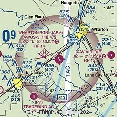
| Sectional chart |
|---|
|
| Airport distance calculator |
|---|
|
|
| Sunrise and sunset |
|---|
|
Times for 17-Jan-2026
| | Local
(UTC-6) | | Zulu
(UTC) |
|---|
| Morning civil twilight | | 06:55 | | 12:55 |
| Sunrise | | 07:21 | | 13:21 |
| Sunset | | 17:49 | | 23:49 |
| Evening civil twilight | | 18:15 | | 00:15 |
|
| Current date and time |
|---|
| Zulu (UTC) | 17-Jan-2026 13:26:07 |
|---|
| Local (UTC-6) | 17-Jan-2026 07:26:07 |
|---|
|
| METAR |
|---|
| KARM | 171315Z AUTO 01009KT 10SM BKN080 09/M06 A3019 RMK AO2 T00861058 TSNO
|
|
| TAF |
|---|
KSGR
34nm NE | 171120Z 1712/1812 36012G20KT P6SM BKN060 FM171500 01015G25KT P6SM SCT250 FM180200 35010KT P6SM BKN150
|
KLBX
37nm E | 171120Z 1712/1812 01015G25KT P6SM SCT100 FM180200 35014KT P6SM BKN100
|
|
| NOTAMs |
|---|
NOTAMs are issued by the DoD/FAA and will open in a separate window not controlled by AirNav.
|
|

