FAA INFORMATION EFFECTIVE 14 MAY 2026
Location
| FAA Identifier: | ELA |
| Lat/Long: | 29-36-00.1000N 096-19-19.0000W
29-36.001667N 096-19.316667W
29.6000278,-96.3219444
(estimated) |
| Elevation: | 184.1 ft. / 56.1 m (surveyed) |
| Variation: | 05E (2005) |
| From city: | 1 mile NE of EAGLE LAKE, TX |
| Time zone: | UTC -5 (UTC -6 during Standard Time) |
| Zip code: | 77434 |
Airport Operations
| Airport use: | Open to the public |
| Activation date: | 03/1949 |
| Control tower: | no |
| ARTCC: | HOUSTON CENTER |
| FSS: | MONTGOMERY COUNTY FLIGHT SERVICE STATION |
| NOTAMs facility: | ELA (NOTAM-D service available) |
| Attendance: | IREG
FOR SVC AFT HRS CALL 713-502-4064 |
| Wind indicator: | lighted |
| Segmented circle: | yes |
| Lights: | MIRL RWY 17/35 PRESET LOW; TO INCR INTST ACTVT - CTAF. |
| Beacon: | white-green (lighted land airport)
Operates sunset to sunrise. |
Airport Communications
| CTAF: | 122.9 |
| WX AWOS-3PT: | 128.475 (979-234-2665) |
| HOUSTON APPROACH: | 124.225 |
| HOUSTON DEPARTURE: | 124.225 |
| WX AWOS-3 at 66R (10 nm W): | 123.875 (979-732-2514) |
Airport Services
| Fuel available: | 100LL JET-A |
| Parking: | tiedowns |
| Bottled oxygen: | NONE |
| Bulk oxygen: | NONE |
Runway Information
Runway 17/35
| Dimensions: | 4280 x 60 ft. / 1305 x 18 m |
| Surface: | asphalt, in good condition |
| Weight bearing capacity: | |
| Runway edge lights: | medium intensity |
| RUNWAY 17 | | RUNWAY 35 |
| Latitude: | 29-36.350355N | | 29-35.652353N |
| Longitude: | 096-19.377698W | | 096-19.255238W |
| Elevation: | 183.9 ft. | | 181.9 ft. |
| Traffic pattern: | left | | right |
| Runway heading: | 166 magnetic, 171 true | | 346 magnetic, 351 true |
| Markings: | nonprecision, in good condition | | nonprecision, in good condition |
| Visual slope indicator: | 2-light PAPI on left (3.00 degrees glide path) | | 2-light PAPI on left (3.00 degrees glide path) |
| Touchdown point: | yes, no lights | | yes, no lights |
| Obstructions: | none | | 15 ft. road, 201 ft. from runway, 69 ft. left of centerline
15 FT RD, 68 FT DSTC, 220 FT R; 15 FT RD, 27 FT DSTC, 250 R. |
Airport Ownership and Management from official FAA records
| Ownership: | Publicly-owned |
| Owner: | CITY OF EAGLE LAKE
PO BOX 38
EAGLE LAKE, TX 77434
Phone 979-234-2640 |
| Manager: | VICTOR SHIMEK
PO BOX 38
EAGLE LAKE, TX 77434
Phone 979-234-2640
CITY INSPECTOR/ARPT MGR. |
Additional Remarks
| - | FOR CD CTC HOUSTON APCH AT 281-443-5844 TO CNL IFR CALL 281-443-5888. |
Instrument Procedures
NOTE: All procedures below are presented as PDF files. If you need a reader for these files, you should download the free Adobe Reader.NOT FOR NAVIGATION. Please procure official charts for flight.
FAA instrument procedures published for use from 14 May 2026 at 0901Z to 11 June 2026 at 0900Z.
IAPs - Instrument Approach Procedures |
|---|
| RNAV (GPS) RWY 17 | |
download (179KB) |
| RNAV (GPS) RWY 35 | |
download (164KB) |
| NOTE: Special Alternate Minimums apply | |
download (124KB) |
| NOTE: Special Take-Off Minimums/Departure Procedures apply | |
download (219KB) |
Other nearby airports with instrument procedures:
KARM - Wharton Regional Airport (23 nm SE)
KTME - Houston Executive Airport (25 nm NE)
KSGR - Sugar Land Regional Airport (35 nm E)
KIWS - West Houston Airport (36 nm E)
11R - Brenham Municipal Airport (37 nm N)
|
|

Road maps at:
MapQuest
Bing
Google
| Aerial photo |
|---|
WARNING: Photo may not be current or correct

Do you have a better or more recent aerial photo of Eagle Lake Airport that you would like to share? If so, please send us your photo.
|
| Sectional chart |
|---|
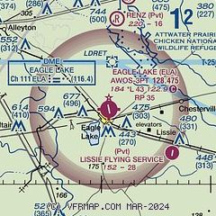
|
| Airport distance calculator |
|---|
|
|
| Sunrise and sunset |
|---|
|
Times for 28-May-2026
| | Local
(UTC-5) | | Zulu
(UTC) |
|---|
| Morning civil twilight | | 06:01 | | 11:01 |
| Sunrise | | 06:28 | | 11:28 |
| Sunset | | 20:18 | | 01:18 |
| Evening civil twilight | | 20:44 | | 01:44 |
|
| Current date and time |
|---|
| Zulu (UTC) | 28-May-2026 14:35:20 |
|---|
| Local (UTC-5) | 28-May-2026 09:35:20 |
|---|
|
| METAR |
|---|
| KELA | 281415Z AUTO 28003KT 10SM CLR 21/20 A2996 RMK AO2 T02070201
|
K66R
10nm W | 281415Z AUTO 28003KT 10SM CLR 22/21 A2997 RMK AO2 T02160207
|
|
| TAF |
|---|
KSGR
35nm E | 281313Z 2813/2912 00000KT 4SM BR SKC FM281400 VRB04KT P6SM FEW020 SCT070 FM282000 12005KT P6SM SCT050 FM290500 19001KT 5SM BR SCT040
|
|
| NOTAMs |
|---|
NOTAMs are issued by the DoD/FAA and will open in a separate window not controlled by AirNav.
|
|

