FAA INFORMATION EFFECTIVE 09 JULY 2026
Location
| FAA Identifier: | IWS |
| Lat/Long: | 29-49-05.5000N 095-40-21.4000W
29-49.091667N 095-40.356667W
29.8181944,-95.6726111
(estimated) |
| Elevation: | 111 ft. / 33.8 m (surveyed) |
| Variation: | 05E (1995) |
| From city: | 13 miles W of HOUSTON, TX |
| Time zone: | UTC -5 (UTC -6 during Standard Time) |
| Zip code: | 77084 |
Airport Operations
| Airport use: | Open to the public |
| Activation date: | 04/1964 |
| Control tower: | no |
| ARTCC: | HOUSTON CENTER |
| FSS: | MONTGOMERY COUNTY FLIGHT SERVICE STATION |
| NOTAMs facility: | CXO (NOTAM-D service available) |
| Attendance: | CONTINUOUS |
| Wind indicator: | lighted |
| Segmented circle: | yes |
| Lights: | DUSK-DAWN. HIRL RWY 15/33 PRESET LOW INTST; TO INCR INTST & ACTVT REIL RWYS 15 & 33 - CTAF. |
| Beacon: | white-green (lighted land airport)
Operates sunset to sunrise. |
| Landing fee: | yes, FACILITY FEE CHARGED TO NON-PATRONS, WAIVED WITH MINIMUM PURCHASE. |
Airport Communications
| CTAF/UNICOM: | 123.05 |
| HOUSTON APPROACH: | 123.8 |
| HOUSTON DEPARTURE: | 123.8 |
| CLEARANCE DELIVERY: | 121.15 |
| ALEXANDRIA DP: | 123.8 |
| BLTWY RNAV DP: | 123.8 |
| BLUBELL STAR: | 124.225 |
| BORRN RNAV DP: | 123.8 |
| CESAN STAR: | 121.3 |
| CRIED DP: | 123.8 |
| DREMR DP: | 123.8 |
| EL DORADO DP: | 123.8 |
| GIFFA DP: | 123.8 |
| HOODO RNAV DP: | 123.8 |
| HUDZY STAR: | 120.05 |
| INDIE RNAV DP: | 123.8 |
| KARRR RNAV DP: | 123.8 |
| LEONA DP: | 123.8 |
| LUFKIN DP: | 123.8 |
| LURIC DP: | 123.8 |
| MMALT RNAV DP: | 123.8 |
| OHIIO STAR: | 120.05 |
| SNDAY RNAV STAR: | 124.225 |
| STRYA DP: | 123.8 |
| STYCK DP: | 123.8 |
| TKNIQ STAR: | 119.625 |
| TSHIRT STAR: | 119.175 |
| TSHRT STAR: | 119.175 |
| WAPPL STAR: | 120.05 |
| WATFO DP: | 123.8 |
| WYLSN RNAV DP: | 123.8 |
| WX AWOS-3 at TME (12 nm W): | 119.525 (281-574-7296) |
| WX ASOS at SGR (12 nm S): | PHONE 281-242-7605 |
| WX ASOS at DWH (16 nm NE): | 128.375 (281-251-7853) |
| WX ASOS at IAH (20 nm NE): | PHONE 713-338-9561 |
Nearby radio navigation aids
| VOR radial/distance | | VOR name | | Freq | | Var |
|---|
| IAHr239/18.9 | | HUMBLE VORTAC | | 116.60 | | 05E |
| TNVr137/34.6 | | NAVASOTA VOR/DME | | 115.90 | | 08E |
Airport Services
| Fuel available: | 100LL JET-A+ |
| Parking: | hangars and tiedowns |
| Airframe service: | MAJOR |
| Powerplant service: | MAJOR |
| Bottled oxygen: | HIGH/LOW |
| Bulk oxygen: | HIGH/LOW |
Runway Information
Runway 15/33
| Dimensions: | 3953 x 75 ft. / 1205 x 23 m |
| Surface: | asphalt, in good condition |
| Weight bearing capacity: | | Single wheel: | 18.0 | | Double wheel: | 44.0 |
|
| Runway edge lights: | high intensity |
| Runway edge markings: | NSTD NPI MARKINGS DUE TO RWY LEN. NO AIMING POINT. |
| RUNWAY 15 | | RUNWAY 33 |
| Latitude: | 29-49.386122N | | 29-48.796630N |
| Longitude: | 095-40.516137W | | 095-40.196257W |
| Elevation: | 110.5 ft. | | 108.9 ft. |
| Traffic pattern: | left | | left |
| Runway heading: | 150 magnetic, 155 true | | 330 magnetic, 335 true |
| Markings: | NSTD, in good condition | | NSTD, in good condition |
| Visual slope indicator: | 2-light PAPI on right (3.70 degrees glide path) | | 2-light PAPI on left (3.70 degrees glide path) |
| Runway end identifier lights: | yes | | yes |
| Touchdown point: | yes, no lights | | yes, no lights |
| Obstructions: | 50 ft. trees, 600 ft. from runway, 60 ft. left and right of centerline, 8:1 slope to clear | | 15 ft. road, 200 ft. from runway, 60 ft. right of centerline
15 FT ROAD 150 FT EAST OF THR. |
Airport Ownership and Management from official FAA records
| Ownership: | Privately-owned |
| Owner: | WEST HOUSTON AIRPORT CORP
BOX 941789
HOUSTON, TX 77094-8789
Phone 281-492-2130 |
| Manager: | WOODY LESIKAR
BOX 941789
HOUSTON, TX 77094-8789
Phone 281-492-2130 |
Additional Remarks
| - | 20 FT DEEP, 25 FT WIDE DITCH, 0-166 FT DSTC ACRS APCH. |
| - | NO TGLS BTN 2200-0600. |
| - | NO NGT HEL TRNG. |
| - | NO MULT TRNG FLTS BY HELS. |
| - | WX INFO AVBL ON 125.575, 281-579-9820. ASRI 129.875. |
| - | FOR CD CTC HOUSTON APCH AT 281-443-5844. TO CNL IFR CTC HOUSTON APCH AT 281-443-5888. |
Instrument Procedures
NOTE: All procedures below are presented as PDF files. If you need a reader for these files, you should download the free Adobe Reader.NOT FOR NAVIGATION. Please procure official charts for flight.
FAA instrument procedures published for use from 09 July 2026 at 0901Z to 06 August 2026 at 0900Z.
STARs - Standard Terminal Arrivals |
|---|
| CESAN FOUR (RNAV) **CHANGED** | |
2 pages:
[1] [2] (405KB) |
| HUDZY FIVE **CHANGED** | |
2 pages:
[1] [2] (282KB) |
| OHIIO FOUR **CHANGED** | |
download (265KB) |
| SNDAY ONE (RNAV) **CHANGED** | |
download (233KB) |
| TKNIQ THREE (RNAV) **CHANGED** | |
2 pages:
[1] [2] (330KB) |
| TSHRT TWO **CHANGED** | |
2 pages:
[1] [2] (341KB) |
| WAPPL SEVEN (RNAV) **CHANGED** | |
2 pages:
[1] [2] (406KB) |
| WAPPL SEVEN (RNAV), CONT.2 **NEW** | |
download (283KB) |
IAPs - Instrument Approach Procedures |
|---|
| RNAV (GPS) RWY 15 | |
download (184KB) |
| RNAV (GPS) RWY 33 | |
download (171KB) |
Departure Procedures |
|---|
| ALEXANDRIA THREE | |
2 pages:
[1] [2] (302KB) |
| BLTWY SEVEN (RNAV) | |
download (151KB) |
| BORRN SIX (RNAV) | |
2 pages:
[1] [2] (298KB) |
| CRIED ONE | |
download (146KB) |
| EL DORADO ONE | |
download (160KB) |
| GIFFA ONE | |
download (146KB) |
| HOODO SEVEN (RNAV) | |
download (193KB) |
| INDIE EIGHT (RNAV) | |
download (178KB) |
| KARRR SEVEN (RNAV) | |
2 pages:
[1] [2] (244KB) |
| LEONA FOUR | |
2 pages:
[1] [2] (317KB) |
| LUFKIN FOUR | |
2 pages:
[1] [2] (231KB) |
| LURIC EIGHT (RNAV) | |
download (201KB) |
| MMALT SEVEN (RNAV) | |
download (207KB) |
| STRYA EIGHT (RNAV) | |
download (189KB) |
| STYCK EIGHT (RNAV) | |
download (177KB) |
| WATFO SIX (RNAV) | |
download (161KB) |
| WYLSN EIGHT (RNAV) | |
download (164KB) |
| NOTE: Special Take-Off Minimums/Departure Procedures apply | |
download (70KB) |
Other nearby airports with instrument procedures:
KTME - Houston Executive Airport (12 nm W)
KSGR - Sugar Land Regional Airport (12 nm S)
KDWH - David Wayne Hooks Memorial Airport (16 nm NE)
KIAH - George Bush Intercontinental/Houston Airport (20 nm NE)
KAXH - Houston Southwest Airport (21 nm SE)
|
|

Road maps at:
MapQuest
Bing
Google
| Aerial photo |
|---|
WARNING: Photo may not be current or correct
 Photo taken 03-May-2013
looking northwest.
Photo taken 03-May-2013
looking northwest.
Do you have a better or more recent aerial photo of West Houston Airport that you would like to share? If so, please send us your photo.
|
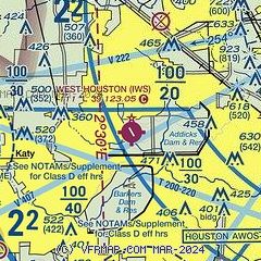
| Sectional chart |
|---|
|
CAUTION: Diagram may not be current

| Airport distance calculator |
|---|
|
|
| Sunrise and sunset |
|---|
|
Times for 25-Jul-2026
| | Local
(UTC-5) | | Zulu
(UTC) |
|---|
| Morning civil twilight | | 06:13 | | 11:13 |
| Sunrise | | 06:39 | | 11:39 |
| Sunset | | 20:19 | | 01:19 |
| Evening civil twilight | | 20:46 | | 01:46 |
|
| Current date and time |
|---|
| Zulu (UTC) | 26-Jul-2026 00:19:22 |
|---|
| Local (UTC-5) | 25-Jul-2026 19:19:22 |
|---|
|
| METAR |
|---|
KTME
12nm W | 252355Z AUTO 20009KT 7SM CLR 32/22 A3003 RMK AO2
|
KSGR
12nm S | 252353Z 15011KT 10SM CLR 32/23 A3002 RMK AO2 SLP167 T03170233 10339 20317 56010 $
|
KDWH
16nm NE | 252353Z AUTO 17006KT 7SM BKN065 32/22 A3002 RMK AO2 SLP162 T03220222 10350 20311 56010 $
|
KIAH
19nm NE | 252353Z 16008KT 10SM FEW060 SCT200 BKN250 32/20 A3002 RMK AO2 SLP164 T03220200 10350 20322 56009
|
KAXH
21nm SE | 252355Z AUTO 19004KT CLR 31/23 A3004 RMK AO2 T03120225 10340 20307 PWINO
|
KHOU
23nm SE | 252353Z 19010KT 10SM FEW060 SCT180 BKN250 32/23 A3002 RMK AO2 SLP170 T03170233 10333 20317 56010 $
|
|
| TAF |
|---|
KSGR
12nm S | 251720Z 2518/2618 18008KT P6SM FEW045 BKN250 FM261200 20003KT P6SM SCT020 BKN035
|
KIAH
19nm NE | 252053Z 2521/2624 16007KT P6SM FEW045 BKN250 FM260500 19005KT P6SM FEW020 SCT250 FM261200 23003KT P6SM SCT025 BKN250 FM261900 19005KT P6SM SCT040 BKN250
|
|
| NOTAMs |
|---|
NOTAMs are issued by the DoD/FAA and will open in a separate window not controlled by AirNav.
|
|


