FAA INFORMATION EFFECTIVE 14 MAY 2026
Location
| FAA Identifier: | HOU |
| Lat/Long: | 29-38-44.8794N 095-16-38.0337W
29-38.747990N 095-16.633895W
29.6457998,-95.2772316
(estimated) |
| Elevation: | 46.3 ft. / 14.1 m (surveyed) |
| Variation: | 03E (2015) |
| From city: | 8 miles SE of HOUSTON, TX |
| Time zone: | UTC -5 (UTC -6 during Standard Time) |
| Zip code: | 77061 |
Airport Operations
| Airport use: | Open to the public |
| Activation date: | 01/1939 |
| Control tower: | yes |
| ARTCC: | HOUSTON CENTER |
| FSS: | MONTGOMERY COUNTY FLIGHT SERVICE STATION |
| NOTAMs facility: | HOU (NOTAM-D service available) |
| Attendance: | CONTINUOUS |
| Wind indicator: | yes |
| Segmented circle: | no |
| Lights: | SS-SR |
| Beacon: | white-green (lighted land airport)
Operates sunset to sunrise. |
| Fire and rescue: | ARFF index C |
| International operations: | customs landing rights airport |
Airport Communications
| UNICOM: | 122.95 |
| WX ASOS: | PHONE 713-847-1462 |
| HOBBY GROUND: | 121.9 |
| HOBBY TOWER: | 118.7 256.9 |
| HOUSTON APPROACH: | 119.175 119.625 120.05 ;EAST 124.35 ;WEST 134.45 ;SOUTH |
| HOUSTON DEPARTURE: | 119.7 ;NORTH 123.8 ;WEST 134.45 ;SOUTH |
| CLEARANCE DELIVERY: | 125.45 |
| PRE-TAXI CLEARANCE: | 125.45 |
| ALEXANDRIA DP: | 132.25 |
| BAYYY STAR: | 119.625 |
| BELLR STAR: | 119.175 |
| BLTWY RNAV DP: | 132.25 |
| CESAN STAR: | 121.3 |
| CLASS B: | 119.7 ;NORTH 123.8 ;WEST 127.125 ;EAST 134.45 ;SOUTH |
| CRIED DP: | 132.25 |
| D-ATIS: | 124.6 |
| EL DORADO DP: | 132.25 |
| ELOCO RNAV DP: | 127.125 |
| EMERG: | 121.5 243.0 |
| FINAL: | 119.1 |
| GIFFA DP: | 132.25 |
| HOODO RNAV DP: | 127.125 |
| HUDZY STAR: | 120.05 |
| IC: | 120.05 ;EAST 124.35 ;WEST |
| INDIE DP: | 132.25 |
| KIDDZ STAR: | 119.175 |
| LEONA DP: | 132.25 |
| LUFKIN DP: | 132.25 |
| LURIC RNAV DP: | 132.25 |
| OHIIO STAR: | 120.05 |
| PEECE RNAV DP: | 127.125 |
| PTRON RNAV DP: | 127.125 |
| PUCKS STAR: | 119.625 |
| RETYR DP: | 126.675 |
| SNDAY RNAV STAR: | 124.225 |
| STRYA RNAV DP: | 132.25 |
| STYCK RNAV DP: | 132.25 |
| TKNIQ STAR: | 119.625 |
| TRUAX DP: | 127.125 |
| TSHIRT STAR: | 119.175 |
| TSHRT STAR: | 119.175 |
| WAPPL STAR: | 120.05 |
| WYLSN RNAV DP: | 132.25 |
| WX AWOS-3 at EFD (7 nm E): | 135.575 (713-847-4430) |
| WX ASOS at LVJ (8 nm S): | 118.525 (281-992-1853) |
| WX AWOS-3PT at T41 (11 nm E): | 120.275 (281-471-2206) |
| WX AWOS-3 at AXH (13 nm SW): | 123.625 (281-431-6572) |
| WX ASOS at SGR (20 nm W): | 118.125 (281-242-7605) |
- ASDE-X IN USE. OPERATE TRANSPONDERS WITH ALTITUDE REPORTING MODE AND ADS-B (IF EQUIPPED) ENABLED ON ALL AIRPORT SURFACES.
Nearby radio navigation aids
| VOR radial/distance | | VOR name | | Freq | | Var |
|---|
| IAHr164/19.0 | | HUMBLE VORTAC | | 116.60 | | 05E |
| MHFr275/28.3 | | TRINITY VOR/DME | | 114.75 | | 07E |
| VUHr311/31.1 | | SCHOLES VOR/DME | | 113.00 | | 06E |
Airport Services
| Fuel available: | 100LL JET-A JET-A1 |
| Parking: | hangars and tiedowns |
| Airframe service: | MINOR |
| Powerplant service: | MINOR |
| Bottled oxygen: | HIGH/LOW |
| Bulk oxygen: | HIGH/LOW |
Runway Information
Runway 4/22
| Dimensions: | 7602 x 150 ft. / 2317 x 46 m |
| Surface: | concrete/grooved, in good condition |
| Weight bearing capacity: | | Single wheel: | 75.0 | | Double wheel: | 200.0 | | Double tandem: | 400.0 |
|
| Runway edge lights: | high intensity |
| RUNWAY 4 | | RUNWAY 22 |
| Latitude: | 29-38.346593N | | 29-39.249488N |
| Longitude: | 095-17.119327W | | 095-16.122732W |
| Elevation: | 42.0 ft. | | 38.9 ft. |
| Traffic pattern: | left | | left |
| Runway heading: | 041 magnetic, 044 true | | 221 magnetic, 224 true |
| Declared distances: | TORA:7602 TODA:7602 ASDA:7602 LDA:7602 | | TORA:7602 TODA:7602 ASDA:7602 LDA:7602 |
| Markings: | precision, in good condition | | precision, in good condition |
| Visual slope indicator: | 4-light PAPI on right (3.00 degrees glide path) | | 4-light PAPI on left (3.00 degrees glide path) |
| RVR equipment: | touchdown, midfield, rollout | | touchdown, midfield, rollout |
| Approach lights: | ALSF2: standard 2,400 foot high intensity approach lighting system with centerline sequenced flashers (category II or III) | | MALS: 1,400 foot medium intensity approach lighting system |
| Centerline lights: | yes | | yes |
| Touchdown point: | yes, lighted | | yes, no lights |
| Instrument approach: | ILS/DME | | LOC/DME |
| Obstructions: | none | | 125 ft. pole, 4400 ft. from runway, 1000 ft. left of centerline, 33:1 slope to clear |
Runway 13R/31L
| Dimensions: | 7602 x 150 ft. / 2317 x 46 m |
| Surface: | asphalt/grooved, in good condition |
| Weight bearing capacity: | | Single wheel: | 75.0 | | Double wheel: | 195.0 | | Double tandem: | 220.0 |
|
| Runway edge lights: | high intensity |
| RUNWAY 13R | | RUNWAY 31L |
| Latitude: | 29-39.056070N | | 29-38.185430N |
| Longitude: | 095-17.130652W | | 095-16.097072W |
| Elevation: | 44.6 ft. | | 41.5 ft. |
| Traffic pattern: | left | | left |
| Runway heading: | 131 magnetic, 134 true | | 311 magnetic, 314 true |
| Displaced threshold: | 1034 ft. | | no |
| Declared distances: | TORA:7602 TODA:7602 ASDA:7602 LDA:6568 | | TORA:7602 TODA:7602 ASDA:7602 LDA:7602 |
| Markings: | precision, in good condition | | precision, in good condition |
| Visual slope indicator: | 4-light PAPI on right (3.00 degrees glide path) | | 4-light PAPI on left (3.00 degrees glide path) |
| RVR equipment: | touchdown | | touchdown |
| Approach lights: | MALSR: 1,400 foot medium intensity approach lighting system with runway alignment indicator lights | | |
| Runway end identifier lights: | | | yes |
| Centerline lights: | yes | | yes |
| Touchdown point: | yes, lighted | | yes, lighted |
| Instrument approach: | ILS/DME | | ILS/DME |
| Obstructions: | 37 ft. pole, 310 ft. from runway, 500 ft. right of centerline, 2:1 slope to clear
APCH RATIO 36:1 TO DSPLCD THR. | | 13 ft. road, 200 ft. from runway, 500 ft. right of centerline |
Runway 13L/31R
| Dimensions: | 5148 x 100 ft. / 1569 x 30 m |
| Surface: | concrete/grooved, in fair condition |
| Weight bearing capacity: | | Single wheel: | 30.0 | | Double wheel: | 45.0 | | Double tandem: | 80.0 |
|
| Runway edge lights: | medium intensity |
| RUNWAY 13L | | RUNWAY 31R |
| Latitude: | 29-39.156433N | | 29-38.566938N |
| Longitude: | 095-17.032272W | | 095-16.332160W |
| Elevation: | 44.9 ft. | | 39.6 ft. |
| Traffic pattern: | left | | left |
| Runway heading: | 131 magnetic, 134 true | | 311 magnetic, 314 true |
| Declared distances: | TORA:5148 TODA:5148 ASDA:5148 LDA:5148 | | TORA:5148 TODA:5148 ASDA:5148 LDA:5148 |
| Markings: | basic, in good condition | | basic, in good condition |
| Visual slope indicator: | 4-light PAPI on left (3.00 degrees glide path) | | |
| Touchdown point: | yes, no lights | | yes, no lights |
Airport Ownership and Management from official FAA records
| Ownership: | Publicly-owned |
| Owner: | CITY OF HOUSTON
16930 JF KENNEDY BLVD
HOUSTON, TX 77032
Phone 281-233-3000 |
| Manager: | STEVE RUNGE
PO BOX 60106
HOUSTON, TX 77205
Phone 713-845-6555 |
Additional Remarks
| A39-13L/31R | PCR VALUE: 200/R/D/W/T |
| A39-04/22 | PCR VALUE: 620/R/C/W/T |
| A39-13R/31L | PCR VALUE: 670/R/B/W/T |
| - | NMRS BIRDS ON AND IN VCNTY OF ARPT. |
| - | CUST RAMP HAS MULT OBSTNS; LARGE ACFT WILL BE ASGND AN ALTN AREA BY ATCT. |
| - | ARPT CLSD TO ACFT WITH WING SPAN OVER 125 FT EXCP 24 HRS PPR CALL OPNS 713-417-5710. |
| - | PILOTS/CREW SHOULD BE AWARE OF DEP TURNS IN EXCESS OF 180 DEGS. READ BACK OF DRCTN OF TURNS IS HIGHLY ENCOURAGED. |
| - | TWY G CNTRLN TO PARKED ACFT ON WEST SIDE ONLY 68 FT. TWY G CNTRLN TO EDGE OF ADJ SVC VEHICLE ROAD ON WEST SIDE ONLY 48 FT. |
| - | DUE TO COMPLEX RWY CONFIGN; WHEN TAX TO THRS 13L & 13R CHECK COMPASS HDG BFR DEPARTING. |
| - | ACFT SOUTHBOUND ON TWY C TO RWY 31L THR USE EXTREME CARE; TWY C MAKES A 45 DEG DOGLEG TO THE LEFT XNG TWY K. |
| - | ACFT IN TKOF PTN ON RWY 22 BE ALERT FOR POSS RADIO INTFC OR NULL ON FREQ 118.7. USE UPPER ANT IF SO EQUIPPED. |
Instrument Procedures
NOTE: All procedures below are presented as PDF files. If you need a reader for these files, you should download the free Adobe Reader.NOT FOR NAVIGATION. Please procure official charts for flight.
FAA instrument procedures published for use from 14 May 2026 at 0901Z to 11 June 2026 at 0900Z.
STARs - Standard Terminal Arrivals |
|---|
| BAYYY FIVE (RNAV) | |
2 pages:
[1] [2] (428KB) |
| BELLR SIX (RNAV) | |
download (364KB) |
| CESAN FOUR (RNAV) | |
2 pages:
[1] [2] (406KB) |
| HUDZY FIVE | |
2 pages:
[1] [2] (284KB) |
| KIDDZ FIVE (RNAV) | |
2 pages:
[1] [2] (563KB) |
| OHIIO FOUR | |
download (266KB) |
| PUCKS FOUR (RNAV) | |
2 pages:
[1] [2] (444KB) |
| SNDAY ONE (RNAV) | |
download (234KB) |
| TKNIQ THREE (RNAV) | |
2 pages:
[1] [2] (331KB) |
| TSHRT TWO | |
2 pages:
[1] [2] (342KB) |
| WAPPL SEVEN (RNAV) | |
2 pages:
[1] [2] (407KB) |
| WAPPL SEVEN (RNAV), CONT.2 | |
download (284KB) |
IAPs - Instrument Approach Procedures |
|---|
| ILS OR LOC RWY 04 | |
download (260KB) |
| ILS OR LOC RWY 13R | |
download (237KB) |
| ILS OR LOC RWY 31L | |
download (248KB) |
| ILS RWY 04 (SA CAT I) | |
download (241KB) |
| ILS RWY 04 (CAT II - III) | |
download (248KB) |
| RNAV (GPS) RWY 04 | |
download (209KB) |
| RNAV (GPS) RWY 13R | |
download (228KB) |
| RNAV (GPS) RWY 22 | |
download (230KB) |
| RNAV (GPS) RWY 31L | |
download (227KB) |
| LOC RWY 22 | |
download (238KB) |
| NOTE: Special Alternate Minimums apply | |
download (140KB) |
Departure Procedures |
|---|
| ALEXANDRIA THREE | |
2 pages:
[1] [2] (341KB) |
| BLTWY SEVEN (RNAV) | |
download (187KB) |
| CRIED ONE | |
2 pages:
[1] [2] (245KB) |
| EL DORADO ONE | |
2 pages:
[1] [2] (256KB) |
| ELOCO SIX (RNAV) | |
download (196KB) |
| GIFFA ONE | |
download (185KB) |
| HOODO SEVEN (RNAV) | |
download (229KB) |
| INDIE EIGHT (RNAV) | |
download (214KB) |
| LEONA FOUR | |
2 pages:
[1] [2] (354KB) |
| LUFKIN FOUR | |
2 pages:
[1] [2] (267KB) |
| LURIC EIGHT (RNAV) | |
download (237KB) |
| PEECE SIX (RNAV) | |
2 pages:
[1] [2] (282KB) |
| PTRON NINE (RNAV) | |
2 pages:
[1] [2] (311KB) |
| RETYR EIGHT (RNAV) | |
2 pages:
[1] [2] (314KB) |
| STRYA EIGHT (RNAV) | |
download (225KB) |
| STYCK EIGHT (RNAV) | |
download (212KB) |
| WYLSN EIGHT (RNAV) | |
download (201KB) |
| NOTE: Special Take-Off Minimums/Departure Procedures apply | |
download (209KB) |
Other nearby airports with instrument procedures:
KEFD - Ellington Airport (7 nm E)
KLVJ - Pearland Regional Airport (8 nm S)
T41 - La Porte Municipal Airport (11 nm E)
KAXH - Houston Southwest Airport (13 nm SW)
KHPY - Baytown Airport (19 nm NE)
KSGR - Sugar Land Regional Airport (20 nm W)
|
|

Road maps at:
MapQuest
Bing
Google
| Aerial photo |
|---|
WARNING: Photo may not be current or correct
 Photo by Taylor Hinson
Photo taken 12-Apr-2011
looking west.
Photo by Taylor Hinson
Photo taken 12-Apr-2011
looking west.
Do you have a better or more recent aerial photo of William P Hobby Airport that you would like to share? If so, please send us your photo.
|
| Sectional chart |
|---|
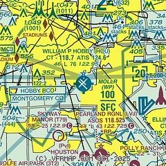
|
CAUTION: Diagram may not be current
 Download PDF
of official airport diagram from the FAA
| Airport distance calculator |
|---|
|
|
| Sunrise and sunset |
|---|
|
Times for 15-May-2026
| | Local
(UTC-5) | | Zulu
(UTC) |
|---|
| Morning civil twilight | | 06:03 | | 11:03 |
| Sunrise | | 06:29 | | 11:29 |
| Sunset | | 20:06 | | 01:06 |
| Evening civil twilight | | 20:32 | | 01:32 |
|
| Current date and time |
|---|
| Zulu (UTC) | 15-May-2026 23:53:58 |
|---|
| Local (UTC-5) | 15-May-2026 18:53:58 |
|---|
|
| METAR |
|---|
| KHOU | 152253Z 17013KT 10SM SCT034 OVC250 28/20 A2991 RMK AO2 SLP134 T02830200 $
|
KEFD
6nm SE | 152154Z 15010G20KT 10SM CLR 29/20 A2991
|
KLVJ
8nm S | 152253Z AUTO 17012KT 10SM SCT032 28/20 A2994 RMK AO2 SLP136 T02780200
|
KT41
11nm E | 152335Z AUTO 18013G16KT 10SM BKN031 27/20 A2995 RMK AO2 T02710204
|
KAXH
13nm SW | 152335Z AUTO 18004KT 10SM SCT033 27/19 A2993 RMK AO2 T02700190
|
KSGR
20nm W | 152253Z 17013KT 10SM CLR 28/21 A2991 RMK AO2 SLP131 T02780206
|
|
| TAF |
|---|
| KHOU | 152121Z 1521/1618 17013G23KT P6SM FEW040 BKN250 FM160200 16011KT P6SM SCT025 BKN200 FM160800 16007KT P6SM SCT015 BKN200 FM161500 16015G25KT P6SM SCT025 SCT250 FM161700 17016G26KT P6SM SCT035 BKN250
|
KSGR
20nm W | 151720Z 1518/1618 18014G22KT P6SM SCT035 FM160200 15011KT P6SM SCT030 BKN200 FM160800 16007KT P6SM SCT020 BKN200 FM161500 16015G25KT P6SM SCT030 SCT250
|
|
| NOTAMs |
|---|
NOTAMs are issued by the DoD/FAA and will open in a separate window not controlled by AirNav.
|
|
FBO, Fuel Providers, and Aircraft Ground Support |
|---|
| | 
Business Name | |
Contact | |
Services / Description | |
Fuel Prices | |
Comments | |
|---|
 |
|
ASRI 131.25
713-649-8700
[web site]
[email] |
|
Voted #1 Best Small FBO Chain for the 15th time by the Pro Pilot's PRASE Survey, Wilson Air Center continues to be recognized for unparalleled service and attention to detail. Wilson Air Center provides award winning services at all of our locations. With professional, hotel-style concierge service to make sure every detail is taken care of and every expectation exceeded, you'll notice the difference at Wilson Air Center. WAC-HOU is open 24/7 and ready to take care of all your FBO needs!
Experience Houston Hospitality at our newly renovated lobby! Come see why we are "The Plane Best!"


|
|
|
|

write
|
|
 |
|
ASRI 131.90
713-640-4000
toll-free 888-589-9059
[web site]
[email] |
|
Million Air has been ranked #1 in Top FBO Chain every year since 2012 and ranked in the Top 50 US FBO's. Our professionalism and customer service is UNPARALLELED! All major FUEL programs ACCEPTED!


|
|
 | | 100LL | Jet A | | FS | | $9.64 | | $8.62 | | GUARANTEED |  | MEMBERS
ONLY
Discounts |
| |
|
|
write
|
|


|
|
ASRI 131.975
713-358-9100
[web site]
[email] |
|
Our fully equipped and newly remodeled Houston FBO offers domestic and international handling, catering, aircraft cleaning and refueling, and comfortable, private amenities for passengers and crew. The facility is part of a global company with some 50 locations and a network of 29 IS-BAH Stage 2 registered FBO's; it is also part of the Air Elite Network. Our newly upgraded Executive terminal offers everything our customer needs, under one roof.


|
|
|
|
write
|
|
 |
|
ASRI 130.75
713-644-6431
[web site]
[email] |
|
Atlantic Aviation is your premier aviation service provider with more than 100 locations in North America, including Hawaii and the Caribbean. We provide standard ground services you'd expect, with a detailed focus on ensuring an unforgettable customer experience.
|
|
 | | 100LL | Jet A | | FS | | $8.66 | | $8.94 | | Updated 15-May-2026 |
|
|
write
|
|


|
|
ASRI 130.50
713-782-7878
[web site]
[email]

|
|
The newest FBO in the world (and the Galaxy!) Visit us at KHOU, with our low fuel price, brand-new high-end facility and top-notch customer service. At Galaxy FBO, we strive to meet and exceed your expectations, continuously working on ways to improve your experience.


|
|
|
|
1 read write
|
|
 |
|
ASRI 130.575
713-353-5300
[web site]
[email] |
|
Signature Aviation at William P. Hobby Airport (HOU) delivers safe, seamless private aviation access and FBO services to downtown Houston and the region's global business and logistics hubs. Operations at our private aviation terminal at HOU are managed with precision and reliability. Request services via Signature Vision:
https://www.signatureaviation.com/services/signature-vision

|
|
| | 100LL | Jet A | SAF | | FS | | $7.58 | | $9.00 | | $10.75 | | Updated 15-May-2026 |
|
|
write
|
|
Alternatives at nearby airports
IMPORTANT: Note that the FBOs below are NOT at KHOU but at other nearby airports. Do not expect services from these FBOs to be available at KHOU. |
 |
|
UNICOM 122.975
toll-free 866-936-2626
281-945-5000
[web site]
[email] |
|
At KTME (Houston Executive Airport), 34 miles WNW
TOWER 126.975 Uniquely positioned as a gateway to Houston and the Energy Corridor, Houston Executive Airport is the newest business aviation airport in the Country.
Come and experience exceptional customer service.
|
|
|
|
2 read write
|
|
 |
|
UNICOM 122.95
281-275-2400
toll-free 866-435-9747
[web site]
[email] |
|
At KSGR (Sugar Land Regional Airport), 20 miles W
Sugar Land Regional Airport is the destination of choice for the business traveler in the Houston area. GlobalSelect provides excellent customer service, and is your luxury gateway to Houston.
|
|
|
|

5 read write
|
|
 |
|
UNICOM 122.95
281-376-5436
toll-free 800-624-7394
[web site]
[email]


|
|
At KDWH (David Wayne Hooks Memorial Airport), 29 miles NNW
At Gill Aviation, our promise is to be your trusted source in Houston by delivering reliable flight support and an excellent customer value. We can assist with all of your concierge needs including courtesy cars, hotel reservations and catering arrangements. We are driven by our ability to listen and respond in a timely manner with attention to detail. With over 200 hangars on field, we have room for your aircraft and volume discounts are available. Be sure to check out our on-site restaurant, Aviator's Grill, and enjoy the famous bacon cheeseburger or one of the many other signature entrees.
|
|
| Located at KDWH |  | | 100LL | Jet A | | FS | | $7.40 | | $7.79 | | SS | | $6.90 | | --- | | GUARANTEED | | MEMBERS
ONLY
Discounts |
| |
|
|

4 read write
|
|

|
| |
Aviation Businesses, Services, and Facilities |
|---|
| |
Business Name | |
Contact | |
Services / Description | |
Distance | |
Comments | |
|---|
 |
|
toll-free 877-296-8391
[web site]
[email] |
|
Aircraft cleaning / washing / detailing
|
|
on airport |
|
write
|
|
|
|
|
281-565-9700
[web site]
[email]

|
|
Western Airways is a Part 145 Repair Station providing routine maintenance, emergency repairs and annual/phase inspections for pistons, turboprops and jets. Western has a full-service Avionics Department performing upgrades, repairs and ADS-B and Wi-Fi installations. AOG mobile service available.

|
|
20 miles |
|
write
|
|
| Houston Aeronautical Heritage Society |
|
713-454-1940
|
|
no information available
If you are affiliated with Houston Aeronautical Heritage Society and would like to show here your services, contact info, web link, logo, and more, click here
|
|
on airport |
|
write
|
|
| |
Getting Around: Taxi, Limo, Rental Cars, Mass Transit |
|---|
| |
Business Name | |
Contact | |
Services / Description | |
Comments | |
|---|
| METRO bus # 41, 50, 73, 88, 143 |
|
[web site]
|
|
no information available
If you are affiliated with METRO bus # 41, 50, 73, 88, 143 and would like to show here your services, contact info, web link, logo, and more, click here
|
|
write
|
|
| |
Would you like to see your business listed on this page? |
|---|
| | If your business provides an interesting product or service to pilots, flight crews, aircraft, or users of the William P Hobby Airport, you should consider listing it here. To start the listing process, click on the button below

|


